- Daebu Island
-
Daebu Island
대부도
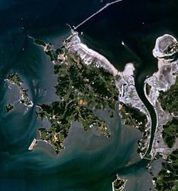
大阜島— Dong — Korean transcription(s) - Hangul 대부도 - Hanja 大阜島 - Revised Romanization Daebudo - McCune-Reischauer Taebudo View from Malbuheung
 Location in South Korea
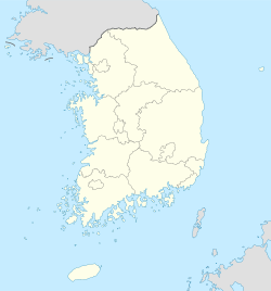
 Daebu Island
Coordinates: 37°16′N 126°35′E / 37.267°N 126.583°E Country  South Korea
Region Sudogwon Administrative divisions 5 dong Area - Total 41.98 km2 (16.2 sq mi) Population (December 31, 2009) - Total 7,114 - Density 169.46/km2 (438.9/sq mi) - Dialect Seoul Daebu Island is an island in the Yellow Sea, within the municipal borders of Ansan city, Gyeonggi province. It has a population of roughly 7,114 people and an area of 41.98 km².[1] Due to rising mudflats, the island has merged with neighbouring Seongam-do (Hangeul:선감도) and Tan-do (탄도). Administratively, the island today is divided into five dong: Daebubuk-dong (대부북동), Daebunam-dong (대부남동), Daebudong-dong (대부동동), Seongam-dong (선감동) and Pungdo-dong (풍도동). The predominant industries are tourism and fishing. The island is connected (via Seongam-do and Tan-do) to the mainland in the south-east by road bridges, to Hyeong-do (형도) (and thence the mainland) in the north-east by several routes due to land reclamation efforts, and to Seonjae-do (선재도) (and thence Yeongheung Island (영흥도) and others) to the west by a further road bridge.
Contents
History
During the Goryeo and Joseon Dynasties, Daebu Island was included in the old jurisdiction of Namyang. On March 1, 1914, it was transferred to Bucheon, and on July 1, 1973 responsibility was transferred to Ongjin County (which later became part of Incheon Metropolitan City). On December 26, 1994 the island was moved into the jurisdiction of Ansan, where it remains today.[1]
Education
Daebu Island has three kindergartens, three elementary schools, one middle school and a high school.[1] The island (specifically Seongam-do) is also home to the Gyeonggi English Village's Ansan Camp, an immersion village for students from Gyeonggi Province.[2]
See also
- List of Korea-related topics
- Islands of South Korea
- Geography of South Korea
References
- ^ a b c "안산시 동주민센터에 오신것을 환영합니다 (Ansansi Dongjuminsenteo Osingeoseul Hwanyeonghamnida)". Ansan City Council - Daebu-dong Citizens' Centre. http://www.iansan.net/dongoffice/25_dong/index.jsp. Retrieved 2010-10-01.
- ^ "Welcome to Ansan Camp". Gyeonggi English Village - Ansan Camp. http://evcyber.gg.go.kr:8088/ansan/english/intro/greetings.php. Retrieved 2010-10-01.
External links
Coordinates: 37°16′N 126°35′E / 37.267°N 126.583°E
Categories:- Gyeonggi
- Islands of South Korea
- South Korea geography stubs


Wikimedia Foundation. 2010.