- Dunskey Castle
-
 Dunskey Castle
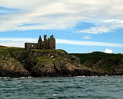
Dunskey Castle is a ruined, early 16th century tower house, located 0.5 miles (0.80 km) south of the village of Portpatrick, Dumfries and Galloway, on the south-west coast of Scotland.
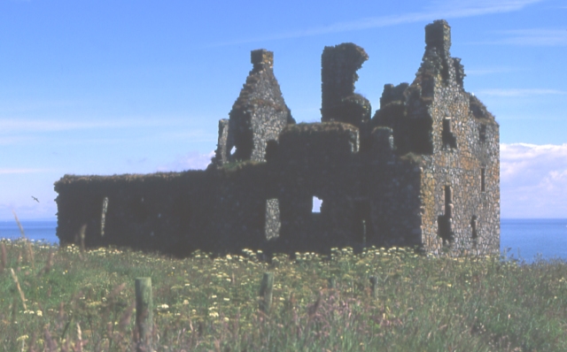
The three-storey L-plan structure is sited on a promontory, with a rock-cut ditch, 15 metres (49 ft) wide by 2.5 metres (8.2 ft) deep, defending the only access, from the north-east.[1] The castle measures 30 by 14.3 metres (98 by 46.9 ft), with walls 1.5 metres (4.9 ft) thick, although the building is now a roofless shell. The north-east wing is of a later date, and the foundations of a south range are visible. Near the castle are the remains of a watchtower, 7 metres (23 ft) square, built on the cliff edge.[2]
A medieval fortification on the site was destroyed in 1489 by Sir Alexander M'Culloch of Myrtoun. The present Dunskey Castle was built by the Adairs of Kinhilt, who also possessed the Castle of St. John in nearby Stranraer, around 1510.[3] In 1620, it was acquired by Hugh Montgomery, 1st Viscount Montgomery, who extended the building.[1] In 1648 it passed to the Blair family, but was ruined by 1684.[3] The current owners have restricted public access to the castle, which is a Scheduled Ancient Monument and a Category A listed building.[1][4]
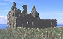 Dunskey Castle from the north-east
References
- ^ a b c "Dunskey Castle, Listed Building Report". Historic Scotland. http://hsewsf.sedsh.gov.uk/hslive/portal.hsstart?P_HBNUM=16777. Retrieved 2008-11-07.
- ^ "Dunskey Castle, NMRS Number: NX05SW 3". CANMORE. RCAHMS. http://www.rcahms.gov.uk/pls/portal/newcanmore.newcandig_details_gis?inumlink=60632. Retrieved 2008-11-07.
- ^ a b Groome, Francis H. (1882-1885). "Dunskey". Ordnance Gazetteer of Scotland: A Survey of Scottish Topography, Statistical, Biographical and Historical. http://www.scottish-places.info/features/featurehistory4691.html. Retrieved 2008-11-07.
- ^ "Certificate of Service of Notice affecting Dunskey Castle". Commissioners of HM Works. 9 November 1938. http://hsewsf.sedsh.gov.uk/eschedule/show?ID=2017&OK=Y. Retrieved 2008-11-07.
External links
 Media related to Dunskey Castle at Wikimedia Commons
- Information from Visit Scotland
Categories:- Castles in Dumfries and Galloway
- Scheduled Ancient Monuments in Scotland
- Category A listed buildings in Scotland
- Listed buildings in Dumfries and Galloway
- Listed castles in Scotland
- 1510s architecture

Wikimedia Foundation. 2010.