- Angern an der March
-
Angern an der March 
 Angern an der March
Country Austria State Lower Austria District Gänserndorf Mayor Robert Meißl (SPÖ) Area 38.13 km2 (15 sq mi) Elevation 154 m (505 ft) Population 3,280 (1 January 2011)[1] - Density 86 /km² (223 /sq mi) Time zone CET/CEST (UTC+1/+2) Postal code 2301 Area code 02215 Website www.angern.at Coordinates: 48°23′0″N 16°50′0″E / 48.383333°N 16.833333°E
Angern an der March (Slovak: Congr) is a market town in the district of Gänserndorf in the Austrian state of Lower Austria. The municipality consists of the Katastralgemeinden Angern, Grub, Mannersdorf, Ollersdorf and Stillfried.
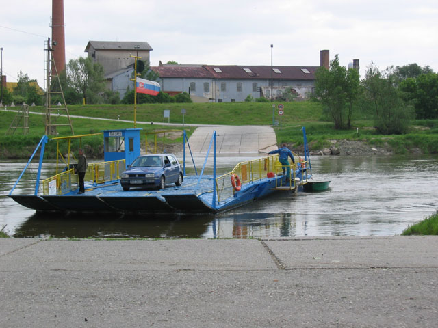
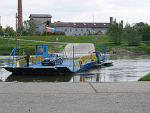 Ferry cross the Morava
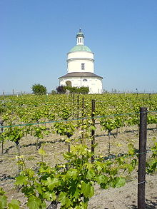 St Roch Chapel
Angern is situated in the Weinviertel region, within the northern Marchfeld basin of the Morava (German: March) river, about 40 kilometers (25 mi) northeast of Vienna. The river forms the border with the village of Záhorská Ves in Slovakia, it is crossed by a small car ferry while plans for rebuilding a former bridge are currently under discussion.
The settlement of Anger in the Duchy of Austria was first mentioned in 1260 deed and already referred to as a market town in 1495, a title that it again received in 1970. The Baroque St Roch Chapel at Mannersdorf was built in 1635. Anger Castle was finally demolished in World War II.
The area is the site of several vineyards.
Subdivisions
See also: KatastralgemeindeTransportation
Angern has access to the Northern Railway (Nordbahn) line from Vienna to Brno. It also lies at the junction of the Bundesstraße B8 Angerner Straße highway from Vienna with the B49 Bernstein Straße, part of the ancient Amber route.
References
Municipalities in the district of Gänserndorf Aderklaa · Andlersdorf · Angern an der March · Auersthal · Bad Pirawarth · Deutsch-Wagram · Drösing · Dürnkrut · Ebenthal · Eckartsau · Engelhartstetten · Gänserndorf · Glinzendorf · Groß-Enzersdorf · Groß-Schweinbarth · Großhofen · Haringsee · Hauskirchen · Hohenau an der March · Hohenruppersdorf · Jedenspeigen · Lassee · Leopoldsdorf im Marchfelde · Mannsdorf an der Donau · Marchegg · Markgrafneusiedl · Matzen-Raggendorf · Neusiedl an der Zaya · Obersiebenbrunn · Orth an der Donau · Palterndorf-Dobermannsdorf · Parbasdorf · Prottes · Raasdorf · Ringelsdorf-Niederabsdorf · Schönkirchen-Reyersdorf · Spannberg · Strasshof an der Nordbahn · Sulz im Weinviertel · Untersiebenbrunn · Velm-Götzendorf · Weiden an der March · Weikendorf · Zistersdorf
Categories:- Cities and towns in Lower Austria
- Cities and towns in Gänserndorf District
- Stillfried family
- Austrian history stubs


Wikimedia Foundation. 2010.