- Chehalem Airpark
-
Chehalem Airpark 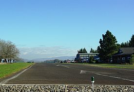
Looking east down the runway IATA: none – ICAO: - FAA: 17S Summary Airport type Public Operator Precision Aviation Location Newberg, Oregon Elevation AMSL 190 ft / 58 m Coordinates 45°19′25.4200″N 123°03′15.3700″W / 45.3237278°N 123.0542694°WCoordinates: 45°19′25.4200″N 123°03′15.3700″W / 45.3237278°N 123.0542694°W Runways Direction Length Surface ft m 7/25 2,285 696 Asphalt Chehalem Airpark (FAA LID: 17S), is a public airport located 4 miles (6.4 km) northwest of Newberg, in Yamhill County, Oregon, USA.
External links
- Precision Aviation
- Resources for this airport:
- AirNav airport information for 17S
- FlightAware airport information and live flight tracker
- SkyVector aeronautical chart for 17S
Categories:- Airports in Yamhill County, Oregon
- Oregon airport stubs
- Oregon building and structure stubs

Wikimedia Foundation. 2010.