Tarawera River

Tarawera River

Infobox_River
river_name = Tarawera River


image_size = 180px
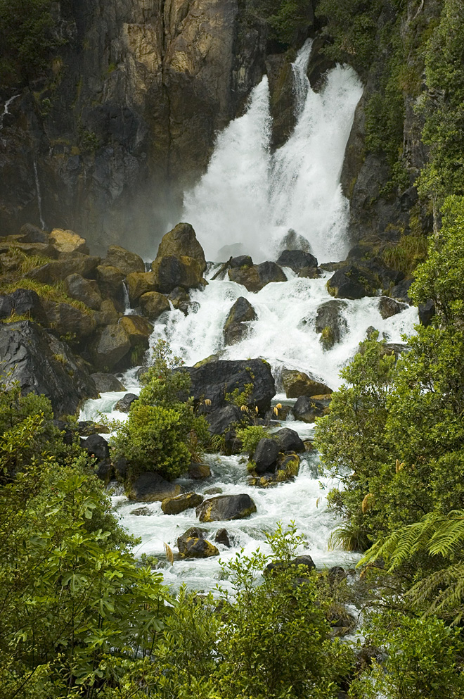
caption = Tarawera Falls on the Tarawera River
origin =
mouth = Bay of Plenty
basin_countries = New Zealand
length = 65 km
elevation =
mouth_elevation =
discharge = 26m3/sec
watershed = 906km2 (measured up to Awakaponga)

The Tarawera River is in the Bay of Plenty region in the North Island of New Zealand.

It flows from Lake Tarawera, northeastwards across the northern flanks of the active volcano Mount Tarawera, and past the town of Kawerau before turning north, reaching the Bay of Plenty six kilometres to the west of Edgecumbe.

The Tarawera Falls on the river are considered to be quite spectacular.

Environmental issues

Since the 1990s local residents have erected signposts labeling the river as the "Black Drain".Citation
last = Park
first = Stephen
author-link =
last2 =
first2 =
author2-link =
title = Colour and Clarity of the Tarawera River 1991-2008
journal =
volume =
issue =
pages =
date = February 2008
year =
url = http://www.ebop.govt.nz/air/media/pdf/0802%20Colour%20&%20Clarity%20in%20the%20Tarawera%20River%201991-2008.pdf
issn=1176-9372
doi =
id =
]

The dark colour is due to the presence of pollution from farms, sewage and stormwater but it is predominanely from pulp and paper mill effluent. As of 1997 pulp and paper mills were discharging over 160 million litres of industrial waste into the river per day. [cite web
last =
first =
authorlink =
coauthors =
title = The State of New Zealand's Environment
work =
publisher = Ministry for the Environment (New Zealand)
date = 1997
url = http://www.mfe.govt.nz/publications/ser/ser1997/html/chapter7.7.html
format =
doi =
accessdate = 2008-03-23
]

By 2006 the oxygen levels in the river had reached a level where fish could survive, however the water colour was still dark. [cite web
last =
first = Environment Bay of Plenty
authorlink =
coauthors =
title = Tarawera River’s future is “looking good”
work =
publisher = Environment Bay of Plenty
date = 2006-05-03
url = http://www.ebop.govt.nz/publications/media/060502-tarawera-ac.doc
format = Microsoft Word
doi =
accessdate = 2008-03-23
] Since 1998 the colour and light penetration (euphotic depth) have improved in the lower section of the river due to less pollution from the Tasman Mill.

References


Wikimedia Foundation. 2010.

Игры ⚽ Нужна курсовая?

Look at other dictionaries:

  • Tarawera River — Die Tarawera Falls Der Tarawera River ist ein Fluss in der Region Bay of Plenty auf der Nordinsel Neuseelands. Er entspringt dem Lake Tarawera und verläuft zuerst in nordöstlicher Richtung über die Nordflanke des Vulkanes Mount Tarawera, vorbei… …   Deutsch Wikipedia

  • Tarawera Falls — am Tarawera River Die Tarawera Falls sind ein Wasserfall am Tarawera River in der Region Bay of Plenty auf der Nordinsel Neuseelands. Sie sind der Abfluss des Lake Tarawera. Der Wasserfall entspringt mitten in einer Felswand, da der Flusslauf vor …   Deutsch Wikipedia

  • Tarawera Falls — Access is from the town of Kawerau and is a drive of about 45 minutes over unsealed roads, followed by a walk of about 20 minutes.The waterfall emerges part way from the rock face as the river is running underground for a distance before emerging …   Wikipedia

  • Lake Tarawera — Geographische Lage Rotorua Distrikt, Bay of Plenty, Nordinsel, Neuseeland Zuflüsse …   Deutsch Wikipedia

  • Mount Tarawera — For other places with the same name, see Tarawera (disambiguation). Mount Tarawera Fissure formed during 1886 Tarawera eruption Elevation …   Wikipedia

  • Lake Tarawera — Infobox lake lake name = Lake Tarawera image lake = Lake Tarawera.jpg caption lake = image bathymetry = caption bathymetry = location = Rotorua District, Bay of Plenty Region, North Island coords = coord|38|12|S|176|27|E|region:NZ… …   Wikipedia

  • Rangitaiki River — zwischen Edgecumbe und ThorntonVorlage:Infobox Fluss/KARTE fehlt …   Deutsch Wikipedia

  • Mount Tarawera —   [maʊnt ], Vulkan auf der Nordinsel Neuseelands, 1 111 m über dem Meeresspiegel, mit dem vorgelagerten See Lake Tarawera (39 km2, 315 m über dem Meeresspiegel, Abfluss durch den Tarawera River zur Bay of Plenty). Durch den schweren Ausbruch von… …   Universal-Lexikon

  • Mokomokonui River — Mouth Waipunga River Basin countries New Zealand Length 16 kilometres (9.9 mi) The Mokomokonui River is a river of the northern Hawke s Bay Region of New Zealand s North Island …   Wikipedia

  • Taupo-Vulkanzone — Mount Ngauruhoe Satellitenfoto des Lake Taupo …   Deutsch Wikipedia

Share the article and excerpts

Direct link
Do a right-click on the link above
and select “Copy Link”