- Newbridge, Oxfordshire
-
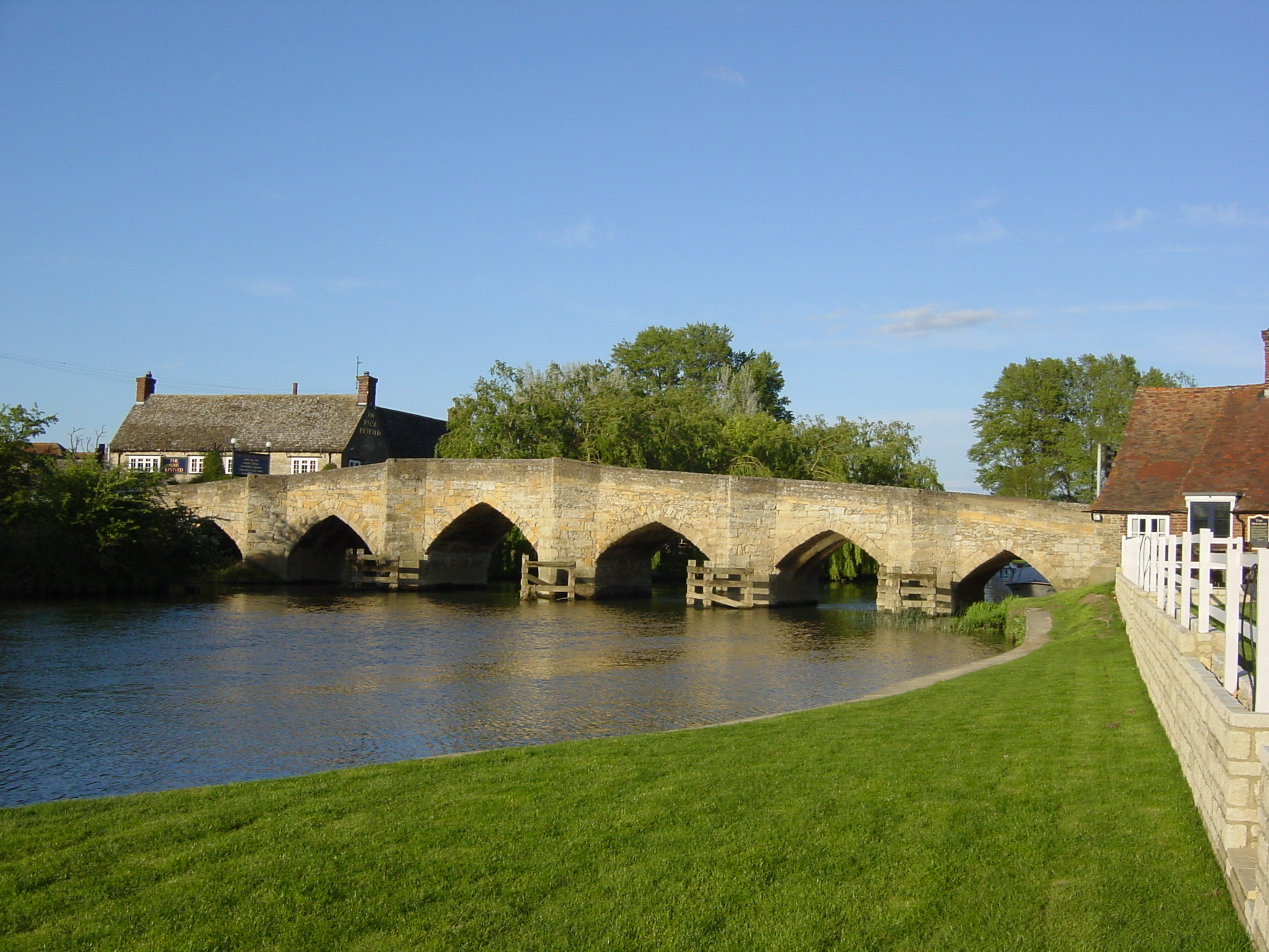
Newbridge 
Newbridge (from the south bank of the Thames)Carries A415 road Crosses River Thames Locale Oxfordshire Maintained by Oxfordshire County Council Design arch Material stone Height 11 feet 6 inches (3.51 m) Number of spans 12 Piers in water 5 Load limit 18 tonnes (18 long tons; 20 short tons) Construction end 1250 Coordinates 51°42′36″N 01°25′02″W / 51.71°N 1.41722°WCoordinates: 51°42′36″N 01°25′02″W / 51.71°N 1.41722°W Newbridge is a 13th century bridge carrying the A415 road over the River Thames in Oxfordshire, between Abingdon and Witney, close to the Thames' confluence with the River Windrush. It is one of the two oldest surviving bridges across the Thames.
There is a public house at either end of the bridge: The Rose Revived on the north bank, and The Maybush on the south bank.
The bridge consists two spans, where the northern span crosses the river and the southern span, south of the Maybush, is dry underneath except when the river floods.[1]
Contents
History
The bridge dates from the 13th century and is constructed with Taynton stone in the same way as Radcot Bridge, which is slightly older. They were built by monks on the orders of King John in order to improve communications between the wool towns in the south of England, and the Cotswold farms, and named "New Bridge" as it was the youngest out of the three bridges built at the time (the third being the Lechlade bridge, replaced in the nineteenth century). It was also very much longer than it is now, with 51 arches and being 726 yards (664 m) long, compared with the current 12 arches.[1]
Whether Newbridge or Radcot Bridge is the oldest surviving crossing of the Thames is debatable. While Radcot Bridge is the older structure, it was extensively damaged during the Wars of the Roses and had to be greatly rebuilt. Further, following reroutings of the Thames in 1787, the Radcot bridge no longer crosses the main channel of the river.[1]
In 1644, during the English Civil War, the Battle of Newbridge was fought on the banks of the river. Roundhead William Waller attempted to cross in order to surround Oxford and capture King Charles, but was defeated.[2][3]
 Newbridge during the floods in the summer of 2007
In 2007 the area was flooded extensively.[4]
Current status
The bridge is controlled by traffic lights, not being designed to carry modern traffic, and an 18 tonnes (18 long tons; 20 short tons) weight limit is imposed to protect its weakening structure.[5] Further reductions are considered likely by local authorities.[6] According to a 1996 survey, one of the arches is only capable of carrying its own weight, though it was decided that there was enough leeway to allow traffic to continue across the bridge. The likelihood of collapse is considered "slim".[6] Local authorities have decided to enter into negotiations to buy land that could be used to build a new bridge 270 yards (250 m) upriver,[7] believing that this is the only long-term option available.[8] The idea of a new bridge is opposed by local residents of Standlake[9][10] who would prefer to see the existing bridge remain open for light traffic only.[11]
See also
- Crossings of the River Thames
References
- ^ a b c Carmichael, Ron (1991). "New Bridge - the oldest bridge over the Thames". Vale and Downland Museum. http://www.wantage.com/museum/Local_History/New%20Bridge.pdf. Retrieved 2007-08-18.
- ^ "Let Battle Commence". BBC. 2007-07-20. http://www.bbc.co.uk/oxford/content/articles/2006/11/30/inspires_battle.shtml. Retrieved 2007-08-18.
- ^ Steane, John (1997). "Medieval Bridges in Oxfordshire". Vale & Downland Museum. http://www.wantage.com/museum/Local_History/Medieval%20Bridges%20in%20Oxfordshire.pdf. Retrieved 2007-08-22.
- ^ "Floods begin to ebb in western England". USA Today. 2007-07-24. http://www.usatoday.com/weather/storms/2007-07-24-europe-weather_N.htm. Retrieved 2007-08-18.
- ^ "Crackdown on lorries using bridge". BBC. 2007-05-15. http://news.bbc.co.uk/1/hi/england/oxfordshire/6658251.stm. Retrieved 2007-08-18.
- ^ a b "Notes of a public meeting on the future of Newbridge and the A415". Standlake Parish Council. 2006-10-10. Archived from the original on 2007-10-11. http://web.archive.org/web/20071011084132/http://www.standlakepc.org.uk/documents/newbridge+10+Oct+meeting+notes.htm. Retrieved 2007-08-18.
- ^ "New bridge at Newbridge plans move forward". Oxfordshire County Council. 2007-09-06. http://www.oxfordshire.gov.uk/wps/portal/publicsite/news?WCM_GLOBAL_CONTEXT=http://apps.oxfordshire.gov.uk/wps/wcm/connect/Internet/Press+releases/Press+Releases+archive/2007/September/PR+-+New+bridge+at+Newbridge+plans+move+forward. Retrieved 2007-09-06.
- ^ "Transport Decisions Committee - 6 September 2007, A415 Newbridge River Thames Crossing, Report by Head of Transport". Oxfordshire County Council. http://www.oxfordshire.gov.uk/content/public/Resources/hlpdownloads/TD/TD060907-12.htm. Retrieved 2007-09-06.
- ^ "Standlake Traffic – Mitigation of effects of possible new crossing at Newbridge". Standlake Parish Council. 2007-07-23. Archived from the original on 2007-10-11. http://web.archive.org/web/20071011084021/http://www.standlakepc.org.uk/documents/Response+to+Nigel+Day+re+A415+mitigation+briefing+10+jul+07.htm. Retrieved 2007-08-18.
- ^ "Standlake Traffic – Mitigation of effects of possible new crossing at Newbridge". Standlake Parish Council. 2007-07-23. Archived from the original on 2007-10-11. http://web.archive.org/web/20071011083856/http://www.standlakepc.org.uk/documents/Response+to+Roger+O'Neill+re+A415+mitigation+briefing+10+jul+07.htm. Retrieved 2007-08-18.
- ^ "Standlake Parish Council minutes, 10 July 2007". Standlake Parish Council. 2007-07-10. http://www.standlakepc.org.uk/documents/10%20jul%2007.htm. Retrieved 2007-09-06.
Next crossing upstream River Thames Next crossing downstream Tenfoot Bridge (pedestrian) Newbridge, Oxfordshire Hart's Weir Footbridge (pedestrian) Next crossing upstream Thames Path Next crossing downstream southern bank
Tenfoot BridgeNewbridge, Oxfordshire northern bank
Pinkhill LockCategories:- Bridges in Oxfordshire
- Bridges completed in the 1250s
- Bridges across the River Thames
- Thames Path

Wikimedia Foundation. 2010.