- San Gorgonio Pass Wind Farm
-
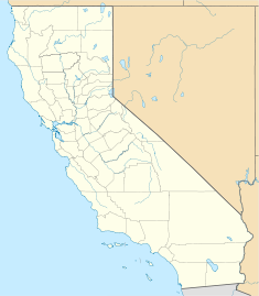
San Gorgonio Pass Wind Farm Location of San Gorgonio Pass Wind Farm Country United States Location Riverside County, California Coordinates 33°54′53.532″N 116°35′18.348″W / 33.91487°N 116.58843°WCoordinates: 33°54′53.532″N 116°35′18.348″W / 33.91487°N 116.58843°W Status Operational Construction began 1980s Turbine information Turbines 3,218 Hub height 160 ft (49 m) (max) Power generation information Installed capacity 615 MW The San Gorgonio Pass Wind Farm is a wind farm located on the eastern slope of the San Gorgonio Pass in Riverside County, just east of White Water, California, United States. Developed beginning in the 1980s, it is one of three major wind farms in California, along with those at Altamont and the Tehachapi passes. The gateway into the Coachella Valley, the San Gorgonio Pass is one of the windiest places in Southern California.
Contents
Utilities
As of January 2008, the farm consists of 3,218 units delivering 615 MW.[1] A single Southern California Edison Path 46 500 kV power line crosses the pass on the northern edge of San Jacinto Peak. This line links the Los Angeles metro area with the Palo Verde Nuclear Power Plant.
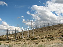
The majority of the San Gorgonio Pass Wind Farm viewed from atop the Palm Springs Aerial Tramway in the San Jacinto Mountains to the south. The farm continues over the hills to the north along California State Route 62. Interstate 10 traverses the image horizontally, and a small portion of State Route 111 is also visible at the bottom of the photo.
History and governance
Wind energy development in the San Gorgonio Pass area was formally studied through the San Gorgonio Wind Resource Study EIR (1982), a joint environmental document prepared for the U.S. Bureau of Land Management and Riverside County. The document assessed three scenarios for wind energy development in the area, and included criteria for the development of wind energy on both a countywide basis and specifically for the San Gorgonio Pass area.[2] Since 1982, and the approval of wind energy development in the San Gorgonio Pass, numerous wind turbines have become part of the landscape. The narrow turbines range from 80 to 160 feet in height.[3]
Involvement with ExxonMobil
In August 1997 ExxonMobil and Southern California Edison jointly constructed a combination oil refinery and storage facility. The plant continues to operate as a refinery while at the same time storing a healthy oil reserve. The refinery and storage facility works in tandem with the wind farm to utilize the energy created in the necessary processes in the refinery process.[4]
References
See also
- Wind power in California
- Wind power in the United States
- List of onshore wind farms
Wind power in the United States Wind power by state 
Large wind farms Alta Wind Energy Center · Altamont Pass · Biglow Canyon · Buffalo Gap · Capricorn Ridge · Fowler Ridge · Horse Hollow · Lone Star · Panther Creek · Peetz · Peñascal · Roscoe · San Gorgonio Pass · Klondike · Shepherds Flat · Sweetwater · Tehachapi Pass · Twin Groves · Windy Point/Windy FlatsWind power companies Clipper Windpower · Deepwater Wind · General Electric · National Wind · Native Wind · NextEra Energy Resources · Siemens Power Generation · Southwest Windpower · Urban Green Energy · Vestas · Wind Capital GroupCategories:- Buildings and structures in Riverside County, California
- Wind farms in California
Wikimedia Foundation. 2010.


