- Durnovaria
-
Durnovaria is the Latin form of the Brythonic name for the Roman town of Dorchester in the modern English county of Dorset.
Contents
Romans at Maiden Castle
 Excavations at Maiden Castle in October 1937. Photograph by Major George Allen (1891–1940).
The pre-Roman population centre in the area appears to have been at the hill fort of Maiden Castle, two miles south-west of the town centre. The inhabitants appear to have resisted the Roman invasion and their war cemetery was excavated in the 1930s by Mortimer Wheeler. It later became the site of a 4th century Romano-British temple.
Roman Dorchester
The site of present-day Dorchester may have originally been a small garrison fort for the Legio II Augusta established shortly after the Roman conquest. When the military moved away, around AD 70, Durnovaria became a civilian settlement, apparently[1] the civitas Durotrigum of the tribal confederacy of the Durotriges. Shafts were dug to deposit ritual foundation items.[2] An organised street plan was laid out, ignoring earlier boundaries, the streets lined with timber-slot structures; public buildings including thermae were erected and an artificial water supply established.[3] The town seems to have become one of twin capitals for the local Durotriges tribe. It was an important local market centre, particularly for Purbeck marble, shale and the pottery industries from Poole Harbour and the New Forest. The town remained small, around the central and southern areas of the present settlement, until expansion to the north-west, around Colliton Park, in the 2nd century. By the middle of this century, the town defences were added and Maumbury Rings, a neolithic henge monument, was converted for use as an amphitheatre. The third century saw the first replacement of timber buildings with stone ones, an unexpectedly late development in an area with several good sources of building stone.[4]There were many fine homes for rich families and their excavated mosaic floors suggest a mosaic school of art had a workshop in the town, members of which seem to have travelled in the area to execute mosaic floors in villas away from Durnovaria itself.[5] A large late-Roman and Christian cemetery has been excavated at Poundbury just to the west of the town, but little is known of Durnovaria's decline after the departure of the Roman administration. The name, however, survived to become the Anglo-Saxon Dornwaraceaster and modern 'Dorchester'.
Extant remains
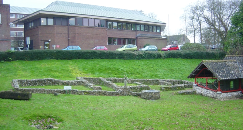
 Roman town house ruins
The town still has some Roman features, including part of the town walls and the foundations of a Roman town house, which are freely accessible near County Hall. There are many Roman finds in the County Museum. The Romans built an aqueduct to supply the town with water but only a few traces remain at nearby Whitfield Farm (Details). Near the town centre is Maumbury Rings, an ancient British earthwork converted by the Romans for use as an amphitheatre, and to the north west is Poundbury Hill, another pre-Roman fortification.
There is little evidence to show whether or not Durnovaria survived into the post-Roman era: Gildas' record of a tradition, given in De Excidio et Conquestu Britanniae iii, of twenty-eight cities and sundry castles of former happy times was not provided with any names. Surviving northern boundaries of the administrative region, or civitas that included Dorset, reached as far as Selwood, and mark the county division between Somerset and Wiltshire to this day.[6] In the sub-Roman period, as urban centres were progressively abandoned, the centres of administration and justice, such as they were, generally removed to fortified strongholds. The city's site is attested as Dornwaraceaster in the ninth century, elided to produce 'Dornaceaster, first recorded in 937.[7]
Notes
- ^ "The fact is nowhere attested", C. E. Stevens noted in 1937, adding that Ptolemy, perhaps using a lost pre-occupation source, gives Durium (Geography ii.3.13) as the one town of the Durotriges,; see Stevens, "Gildas and the Civitates of Britain" The English Historical Review 52 No. 206 (April 1937:193-203) pp 202-03, note 3.
- ^ Sampled shafts in Greyhound Yard, Dorchester, in advance of rebuilding, published by Woodward et al., 1993, were reidentified as on-going ritual deposits, notably of sacrificed puppies and black carrion birds— crows, ravens and jackdaws— summarised by Peter Woodward and Ann Woodward, "Dedicating the Town: Urban Foundation Deposits in Roman Britain" World Archaeology 36.1 (March 2004:68-86) and compared with other Romano-British sites.
- ^ Details are in R.J.C. Smith, Excavations at County Hall, Dorchester, Dorset, 1988, in the North-West Quarter of Durnovaria, (Wessex Archaeology Report 4) Salisbury 1993.
- ^ Remarked upon by J. H. Williams, "Roman Building-Materials in South-East England" Britannia 2 (1971:166-195) p. 170; he noted the quarries of Purbeck Limestone, Lias limestone and Hamstone from Ham Hill.
- ^ D. J. Smith, "The mosaic pavements", in A.L.F. Rivet, ed., The Roman Villa in Britain (1969:71-125).
- ^ Bruce Eagles, "Britons and Saxons on the Eastern Boundary of the Civitas Durotrigum" Britannia 35 (2004:234-240) passim traces clues of identifiable former tribal arrangements reflected in the eastern Roman and post-Roman boundary.
- ^ Anton Fägersten, Place-Names in Dorset (Uppsala) 1933:1-2, noted by F. M. Stenton, "Presidential Address: The Historical Bearing of Place-Name Studies; England in the Sixth Century" Transactions of the Royal Historical Society 4th Ser., 21 (1939:1-19) p. 6 note 1.
Further reading
- Breeze, A., "Durnovaria, the Roman name of Dorchester", Notes & Queries for Somerset & Dorset 35.4 pp 69-72.
Major towns of Roman Britain Londinium (capital of Britannia Superior) - now London
Eboracum (capital of Britannia Inferior) - now York
Camulodunum (first 'capital' of Roman Britain) - now Colchester
Bannaventa* (Northamptonshire) • Caesaromagus - now Chelmsford • Calleva Atrebatum* (Hampshire) • Corinium Dobunnorum - now Cirencester • Deva Victrix - now Chester • Durovernum Cantiacorum - now Canterbury • Durnovaria - now Dorchester • Glevum - now Gloucester • Isca Augusta - now Caerleon • Isca Dumnoniorum - now Exeter • Isurium Brigantum - now Aldborough • Lactodurum - now Towcester • Lindum Colonia - now Lincoln • Luguvalium - now Carlisle • Moridunum - now Carmarthen • Noviomagus Reginorum - now Chichester • Petuaria - now Brough-on-Humber • Ratae Corieltauvorum - now Leicester • Venta Belgarum - now Winchester • Venta Icenorum* (Norfolk) • Venta Silurum - now Caerwent • Verulamium - now St Albans • Viroconium Cornoviorum* (now Wroxeter in Shropshire)See also: List of Roman place names in Britain * Towns labelled with an asterisk have not grown into a modern UK location (their county is shown instead)External links
 Media related to Durnovaria at Wikimedia CommonsCategories:
- Roman towns and cities in England
- Roman Dorchester
- Archaeological sites in Dorset

Wikimedia Foundation. 2010.