Kenwood/47th Street (Metra)
- Kenwood/47th Street (Metra)
Infobox Station
name=47th Street/Kenwood
type=Metra regional rail
image_size=300
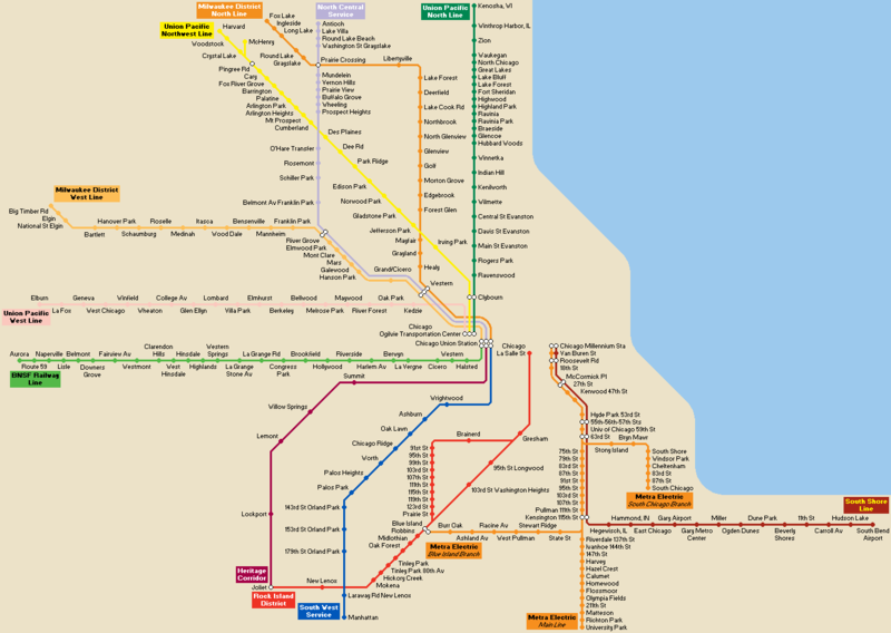
image_caption=Commuter lines serving 47th Street, shown in Panama Orange on this schematic, serve Chicago's southern suburbs in Illinois
address=47th Street near Lake Park Avenue
Kenwood, Chicago, IL
coordinates=
line=Rail color box|system=Metra|line=Metra Electric
other=CTA Bus
structure=
platform=
levels=
tracks=4
parking=
bicycle=
baggage_check=
passengers=
pass_year=
pass_percent=
pass_system=
opened=
closed=
rebuilt=
electrified=
ADA=Yes
code=
owned=METRA
zone=A
former=
services=
mpassengers=The 47th Street Station is a commuter rail station within the city of Chicago that serves the Metra Electric Line north to Millennium Station and south to University Park, the city of Blue Island, and the neighborhood of South Chicago.
The first station at this location was originally built by the Illinois Central railroad (ICRR).
=CTA Bus Connections=
*2: Hyde Park Express
*6: Jackson Park Express
*28: 28 Stony Island
*X28: Stony Island Express
*47: 47th Street
*173: University of Chicago/Lakeview Express
External links
* [http://metrarail.com/Sched/me/47th.shtml Metra Electric - Kenwood/47th Street]
###@@@KEYEND@@@###
Wikimedia Foundation.
2010.
Look at other dictionaries:
Metra Electric Line — Infobox rail line name = Metra Electric Line image width = 250 px caption = A Metra Electric train pulls out of 59th Street station type = Commuter Rail system = Metra status = Operational locale = Chicago, Illinois, USA start = Millennium… … Wikipedia
Toni Preckwinkle — Infobox Politician name = Toni Preckwinkle width = height = birth date = birth date and age|mf=yes|1947|3|17|mf=y city state|St. Paul|Minnesota residence = city state|Chicago|Illinois USA office = City of Chicago Alderman term start = 1991 term… … Wikipedia
Red Line (Chicago Transit Authority) — Red Line A Red Line train in the Jackson/State station Overview Type … Wikipedia
List of Chicago Landmarks — This article is about Chicago Landmarks designated by city government. For National Register places in Chicago, see National Register of Historic Places listings in Chicago … Wikipedia
Douglas, Chicago — Douglas Community area Community Area 35 Douglas Prairie Shores in B … Wikipedia
South Side Elevated — Railroad Création 3 janvier 1888 Dates clés 6 juin 1892 Inauguration du L Disparition 9 janvier … Wikipédia en Français
Métro de Chicago — Chicago L Situation Chicago, Illinois … Wikipédia en Français
South Side, Chicago — This article is about the southern part of the City of Chicago. For the region south of Chicago, see Chicago Southland. The Victory Monument, which listed on the National Register of Historic Places, is located in the Black Metropolis Bronzeville … Wikipedia
Hyde Park, Chicago — Hyde Park, located on the South Side of Chicago, in Cook County, Illinois, United States and seven miles (11 km) south of the Chicago Loop, is a Chicago neighborhood and one of 77 Chicago community areas. It is home to the University of Chicago,… … Wikipedia
South Side (Chicago) — The South Side is a major part of the City of Chicago, which is located in Cook County, Illinois, United States. Much of it has evolved from the city s incorporation of independent townships, such as Hyde Park Township which voted along with… … Wikipedia