Mehringplatz

Mehringplatz
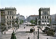
Belle-Alliance-Platz, about 1900
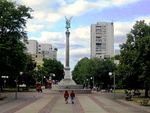
Mehringplatz, 2006

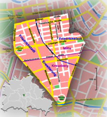
Mehringplatz is a round plaza (or circus)[1] at the southern peak of the Friedrichstadt neighbourhood in Kreuzberg, Berlin. It marks the southern end of Friedrichstraße. Since 1947 it is named after the publicist Franz Mehring (1846–1919).

Location of Mehringplatz within Friedrichstadt, Berlin

Mehringplatz is one of three prominent squares laid out about 1730 in the course of the city's Baroque extension under King Frederick William I of Prussia, beside Pariser Platz (former Karree) and Leipziger Platz (Octogon). Due to its circular shape Mehringplatz was initially named Rondell; in 1815, it was renamed Belle-Alliance-Platz after the Battle of La Belle Alliance, an alternative name for the Battle of Waterloo that was then popular in Prussia. The square was the southern entrance to Berlin via Hallesches Tor, a gate of the new city walls on the road from Halle.

The place was refurbished from the 1830s on including the erection of the Friedenssäule ("Peace Column") with a statue of Victoria by Christian Daniel Rauch in 1843. In World War II the area was completely devastated by an air raid on 3 February 1945 and the following Battle of Berlin. From the 1960s the Mehringplatz was redeveloped as a pedestrian zone in the centre of a large subsidized housing estate according to conceptions by Hans Scharoun ultimately executed by Berlin architect Werner Düttmann. A series of striking murals were created in the 1990s decorating the lower walls of the housing in its courtyard.


Footnotes

  1. ^ A circus is "circular open space at a street junction"

Coordinates: 52°29′56″N 13°23′30″E / 52.49889°N 13.39167°E / 52.49889; 13.39167


Wikimedia Foundation. 2010.

Игры ⚽ Поможем решить контрольную работу

Look at other dictionaries:

  • Mehringplatz — Blick durch das Hallesche Tor nach Norden auf den Belle Alliance Platz mit Bauten der Gründerzeit im Stil des Historismus. Im Vordergrund die Belle Alliance Brücke über den Landwehrkanal (Photochromdruck um 1900) Der Mehringplatz liegt im… …   Deutsch Wikipedia

  • Belle-Alliance-Platz — Der Belle Alliance Platz um 1900 mit historistischem Halleschem Tor prächtiger gründerzeitlicher Platzbebauung Der Mehringplatz liegt im nordwestlichen Teil von Berlin Kreuzberg und ist einer von drei bedeutenden Plätzen, die bei der… …   Deutsch Wikipedia

  • Bellealliance-Platz — Der Belle Alliance Platz um 1900 mit historistischem Halleschem Tor prächtiger gründerzeitlicher Platzbebauung Der Mehringplatz liegt im nordwestlichen Teil von Berlin Kreuzberg und ist einer von drei bedeutenden Plätzen, die bei der… …   Deutsch Wikipedia

  • Das Rondell — Der Belle Alliance Platz um 1900 mit historistischem Halleschem Tor prächtiger gründerzeitlicher Platzbebauung Der Mehringplatz liegt im nordwestlichen Teil von Berlin Kreuzberg und ist einer von drei bedeutenden Plätzen, die bei der… …   Deutsch Wikipedia

  • Friedrichstrasse — Blick in die Friedrichstraße Richtung Süden Die Friedrichstraße liegt in den Berliner Ortsteilen Mitte und Kreuzberg. Sie ist eine der bekanntesten Straßen im Zentrum Berlins und wurde nach dem Kurfürsten Friedrich III. von Brandenburg benannt.… …   Deutsch Wikipedia

  • Friedrichstraße (Berlin) — Blick in die Friedrichstraße Richtung Süden Die Friedrichstraße liegt in den Berliner Ortsteilen Mitte und Kreuzberg. Sie ist eine der bekanntesten Straßen im Zentrum Berlins und wurde nach dem Kurfürsten Friedrich III. von Brandenburg benannt.… …   Deutsch Wikipedia

  • Friedrichstraße — Blick in die Friedrichstraße Richtung Süden Die Friedrichstraße liegt in den Berliner Ortsteilen Mitte und Kreuzberg. Sie ist eine der bekanntesten Straßen im östlichen Zentrum Berlins und wurde nach dem Kurfürsten Friedrich III. von Brandenburg… …   Deutsch Wikipedia

  • Friedrichstadt-Erweiterungen — Wappen Karte Wappen der Friedrichstadt Die historische Fri …   Deutsch Wikipedia

  • Pfad der Visionäre — Offizielle Einweihungsfeier des Projektes am 7. Mai 2006 Der Pfad der Visionäre ist ein Kunstprojekt am südlichen Ende der Friedrichstraße im Berliner Ortsteil Kreuzberg, nahe dem Mehringplatz (ehemals: Belle Alliance Platz). Es besteht aus… …   Deutsch Wikipedia

  • Südliche Friedrichstadt — Wappen Karte Wappen der Friedrichstadt Die historische Fr …   Deutsch Wikipedia

Share the article and excerpts

Direct link
Do a right-click on the link above
and select “Copy Link”