- Astoria Regional Airport
-
Astoria Regional Airport 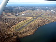
IATA: AST – ICAO: KAST Summary Airport type Public Operator Port of Astoria Location Astoria, Oregon Elevation AMSL 15 ft / 4.6 m Coordinates 46°09′28.7000″N 123°52′43.3000″W / 46.157972°N 123.878694°W Website Runways Direction Length Surface ft m 8/26 5,796 1,767 Asphalt 13/31 4,996 1,523 Asphalt Astoria Regional Airport (IATA: AST, ICAO: KAST), is a public airport located three miles (4.8 km) southwest of the city of Astoria in Clatsop County, Oregon, United States. It is located in the adjacent city of Warrenton.
Airlines and destinations
Airlines Destinations SeaPort Airlines Seattle/Boeing Field Portland International Airport[1] See also
References
- Resources for this airport:
- AirNav airport information for KAST
- ASN accident history for AST
- FlightAware airport information and live flight tracker
- NOAA/NWS latest weather observations
- SkyVector aeronautical chart for KAST
- FAA current AST delay information
Categories:- Airports in Clatsop County, Oregon
- Astoria, Oregon
- Oregon airport stubs
- Oregon building and structure stubs
- Resources for this airport:

Wikimedia Foundation. 2010.