- Tennessee State Route 211
Infobox road
state=TN
type=Secondary
route=211
alternate_name=
maint=TDOT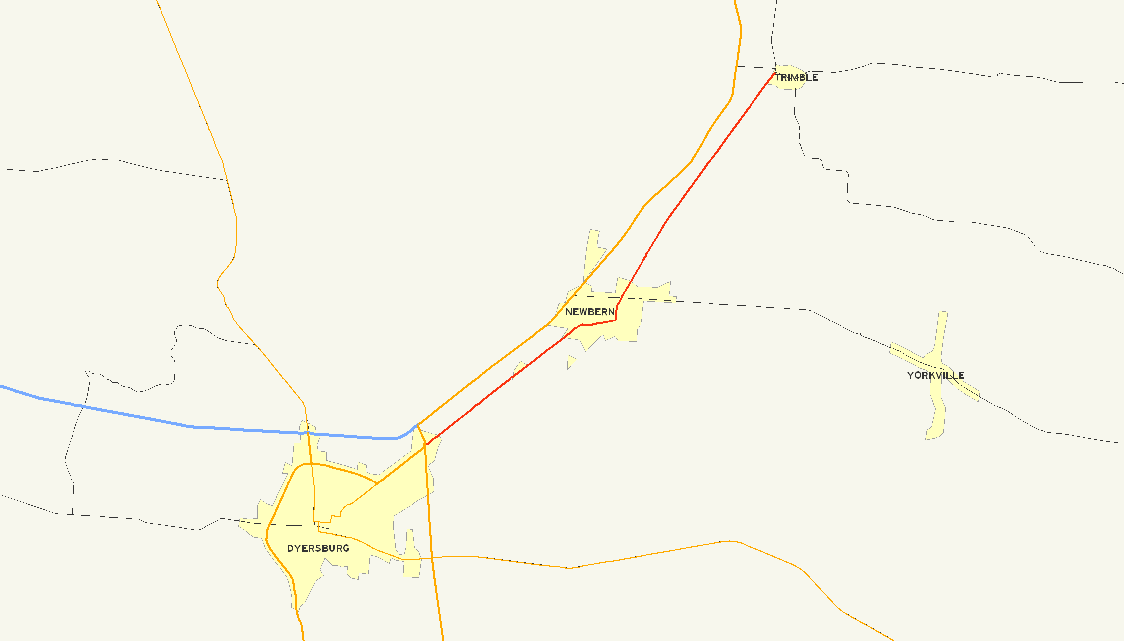
length_mi=17.23
length_round=2
length_ref= [http://www.tdot.state.tn.us/materials/pavement/Documents/Region4(All%20Counties)(PROTECTED).xls TDOT Region 4 Pavement Condition Data] ]
established=
direction_a=South
starting_terminus=jct|state=TN|US|51 at Dyersburg
junction=
direction_b=North
ending_terminus=jct|state=TN|Secondary|105 at Trimble
counties=Dyer
cities=Dyersburg, Newbern, Trimble
previous_type=Secondary
previous_route=210
next_type=Secondary
next_route=212
commons=galleryState Route 211 (abbreviated SR 211) is a 17.23 mile long secondary state route in
Dyer County, Tennessee and, formerly,Obion County, Tennessee . SR 211 is a two-lane highway throughout its length except for a short section in northernDyersburg, Tennessee .Route description
The southern terminus of SR 211 is at a large
3-way junction withUS 51 / SR 3 just south of Dyersburg. SR 211 begins as an unsigned route overlapped with BusinessUS 51 inside thecity limits of Dyersburg. SR 211 briefly overlaps with SR 104 near downtown Dyersburg and withUS 51 on the north side of the city. The route in this area is mostly a two-lane facility with a few four-lane and five-lane sections with a maximum speed limit of 50 MPH (80km/h ). North of Dyersburg, SR 211 is constructed as a two-lane route and is predominately rural in nature. This route passes through downtown Newbern and intersects SR 77 before continuing north toward Trimble. The northern terminus of SR 211 is at Trimble at a 4-wayat-grade intersection with SR 105. North of this intersection, old SR 211 continues north but is closed to traffic. This old alignment provides access to theC.M. Gooch Wildlife Management Area maintained by theTennessee Wildlife Resources Agency [ [http://www.state.tn.us/twra/gis/wmapdf/Gooch.pdf C.M. Gooch Wildlife Management Area - Courtesy TWRA GIS] ] .History
SR 211 is part of an older alignment of US 51 and SR 3.
In the past, SR 211 continued north past
Trimble, Tennessee with a historic northern terminus at theUS 51 freeway just south ofTroy, Tennessee .Tennessee Department of Transportation ended state maintenance on the section of this highway between Trimble, Tennessee andObion, Tennessee due to the deteriorated nature of the bridges along this section of roadway and the derelict Adkison Memorial Bridge over theObion River that has been closed for a number of years [http://www.tdot.state.tn.us/Maps/front.pdf Official Transportation Map] ] [ [http://www.topoquest.com/map.asp?lat=36.25111&lon=-89.19167 Topographic Map of Adkison Memorial Bridge - Courtesy of TopoQuest.com] ] . This orphaned northern portion of SR 211 was eventually deleted and resigned as an extendedTennessee State Route 183 . This highway represents the old two-lane alignment ofUS 51 betweenDyersburg, Tennessee andTroy, Tennessee . North of Troy, Tennessee the old two-lane alignment ofUS 51 resumes and is currently signed asTennessee State Route 184 and runs toUnion City, Tennessee .County maps published by TDOT do not show the recent realignment of this highway [ [http://www.tdot.state.tn.us/Maps/county/co23.pdf Dyer County Highway Map] ] , however, the Official Transportation Map and signs erected in the field reflect the change as stated above. For several years, SR 211 was detoured off its alignment using
Tennessee State Route 105 ,US 51 , andTennessee State Route 183 to avoid the closed section of roadway roughly from the Obion County Line atTrimble, Tennessee north toObion, Tennessee . The detour around this section of highway was removed when SR 211 was truncated toTennessee State Route 105 .Major intersections
jctint
state=TN
county=Dyer
cspan=7
location=Dyersburg
lspan=5
type=
mile=0.0
road=
notes=Southern terminus of SR 211jctint
state=TN
type=mplex
mile=1.9
road= east
notes=Begin SR 104 overlapjctint
state=TN
type=mplex
mile=2.1
road= SR 104 west
notes=End SR 104 overlapjctint
state=TN
type=mplex
mile=3.9
road= US 51 south
notes=Begin US 51 overlapjctint
state=TN
type=mplex
mile=5.5
road=
notes=End US 51 overlap.Parclo Interchange jctint
state=TN
location=Newbern
mile=11.8
road=jctint
state=TN
location=Trimble
mile=17.1
road=
notes=Northern terminus of SR 211External links
[http://www.tdot.state.tn.us Tennessee Department of Transportation]
References
Wikimedia Foundation. 2010.