- Chorin
-
Chorin Brick Gothic Chorin Abbey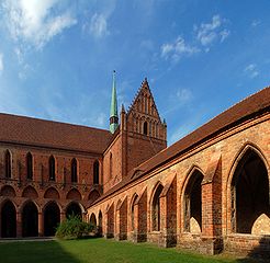

 ChorinLocation of Chorin within Barnim district
Coordinates 52°54′0″N 13°52′0″E / 52.9°N 13.866667°ECoordinates: 52°54′0″N 13°52′0″E / 52.9°N 13.866667°E Administration Country Germany State Brandenburg District Barnim Municipal assoc. Britz-Chorin-Oderberg Local subdivisions 7 Ortsteile Mayor Martin Horst (Ind.) Basic statistics Area 121.62 km2 (46.96 sq mi) Elevation 55 m (180 ft) Population 2,381 (31 December 2010)[1] - Density 20 /km2 (51 /sq mi) Other information Time zone CET/CEST (UTC+1/+2) Licence plate BAR Postal code 16230 Area code 033366 Website www.britz-chorin.de Chorin is a municipality in the district of Barnim in Brandenburg, Germany. It is most famous for its cloister [1] and for being situated within the Schorfheide-Chorin Biosphere Reserve. It is famous for its medieval Brick Gothic Chorin Abbey (Photos).
References
- ^ "Bevölkerung im Land Brandenburg am am 30. Dezember 2010 nach amtsfreien Gemeinden, Ämtern und Gemeinden. Gebietsstand: 31.12.2010" (in German). Amt für Statistik Berlin-Brandenburg. 31 December 2010. http://www.statistik-berlin-brandenburg.de//Publikationen/OTab/2011/OT_A01-04-00_124_201012_BB.pdf.
See also
- Amtssee
External links
 Media related to Chorin at Wikimedia Commons
- Chorin at britz-chorin-oderberg.de (German infopage)
- www.Kloster-Chorin.info (German website about Chorin Abbey)
Ahrensfelde | Althüttendorf | Bernau bei Berlin | Biesenthal | Breydin | Britz | Chorin | Eberswalde | Friedrichswalde | Hohenfinow | Joachimsthal | Liepe | Lunow-Stolzenhagen | Marienwerder | Melchow | Niederfinow | Oderberg | Panketal | Parsteinsee | Rüdnitz | Schorfheide | Sydower Fließ | Wandlitz | Werneuchen | Ziethen Categories:
- Municipalities in Brandenburg
- Brandenburg geography stubs
- Localities in Barnim


Wikimedia Foundation. 2010.