- Oderberg
-
Oderberg is also the German name for Bohumín, a town in the Czech Republic.
Oderberg 

 OderbergLocation of the town of Oderberg within Barnim district
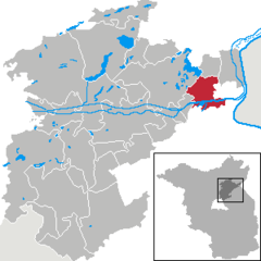
Coordinates 52°52′0″N 14°03′0″E / 52.866667°N 14.05°ECoordinates: 52°52′0″N 14°03′0″E / 52.866667°N 14.05°E Administration Country Germany State Brandenburg District Barnim Municipal assoc. Britz-Chorin-Oderberg Mayor Dr. Klaus Schulenburg (WG BB Oderberg) Basic statistics Area 35.31 km2 (13.63 sq mi) Elevation 5 m (16 ft) Population 2,160 (31 December 2010)[1] - Density 61 /km2 (158 /sq mi) Other information Time zone CET/CEST (UTC+1/+2) Licence plate BAR Postal code 16248 Area code 033369 Website www.amt-oderberg.de Oderberg is a town in the district of Barnim, in Brandenburg, Germany. It is situated 16 km east of Eberswalde, and 27 km southwest of Schwedt and in close vicinity of Berlin.
Overview
The territory has many lakes, remnants from the ice age. The area is widely used for outdoor recreation, such as biking, walking and boating. As Biosphere region it is home to many species of wildlife. Oderberg is closest to the Oder river crossing leading directly to Cedynia, Poland, (until 1945 Zehden, Brandenburg.)
References
- ^ "Bevölkerung im Land Brandenburg am am 30. Dezember 2010 nach amtsfreien Gemeinden, Ämtern und Gemeinden. Gebietsstand: 31.12.2010" (in German). Amt für Statistik Berlin-Brandenburg. 31 December 2010. http://www.statistik-berlin-brandenburg.de//Publikationen/OTab/2011/OT_A01-04-00_124_201012_BB.pdf.
Ahrensfelde | Althüttendorf | Bernau bei Berlin | Biesenthal | Breydin | Britz | Chorin | Eberswalde | Friedrichswalde | Hohenfinow | Joachimsthal | Liepe | Lunow-Stolzenhagen | Marienwerder | Melchow | Niederfinow | Oderberg | Panketal | Parsteinsee | Rüdnitz | Schorfheide | Sydower Fließ | Wandlitz | Werneuchen | Ziethen Categories:
- Towns in Brandenburg
- Localities in Barnim
- Brandenburg geography stubs


Wikimedia Foundation. 2010.