- Mitterfels
-
Mitterfels 

 MitterfelsLocation of Mitterfels within Straubing-Bogen district
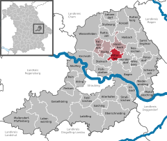
Coordinates 48°58′N 12°41′E / 48.96667°N 12.68333°ECoordinates: 48°58′N 12°41′E / 48.96667°N 12.68333°E Administration Country Germany State Bavaria Admin. region Lower Bavaria District Straubing-Bogen Municipal assoc. Mitterfels Mayor Heinrich Stenzel (Freie Wählergemeinschaft) Basic statistics Area 14.23 km2 (5.49 sq mi) Elevation 407 m (1335 ft) Population 2,445 (31 December 2010)[1] - Density 172 /km2 (445 /sq mi) Other information Time zone CET/CEST (UTC+1/+2) Licence plate SR Postal code 94360 Area code 09961 Website www.mitterfels.de Mitterfels is a municipality in the district of Straubing-Bogen in Bavaria, Germany. It is the head of the Verwaltungsgemeinschaft Mitterfels.
Contents
Geography
Mitterfels is located in the region between the Danube and the Bavarian Forest.
History
In 1104 the dukes of Bogen founded the Monastery Oberalteich. The Castle of Mitterfels was first mentioned in 1194. The Township in today's extent was founded in 1818.
At the census in the year 2000, 2,372 inhabitants lived in Mitterfels.
The mayor of the town is Heinrich Stenzel (Community of Independent Voters). He came into office in 2002 as successor of Werner Lang.
Education
In the year 1999, the following institutions where established:
- A nursery with 70 places and 81 children
- A elementary school with 22 teachers and 362 pupils
Aholfing | Aiterhofen | Ascha | Atting | Bogen | Falkenfels | Feldkirchen | Geiselhöring | Haibach | Haselbach | Hunderdorf | Irlbach | Kirchroth | Konzell | Laberweinting | Leiblfing | Loitzendorf | Mallersdorf-Pfaffenberg | Mariaposching | Mitterfels | Neukirchen | Niederwinkling | Oberschneiding | Parkstetten | Perasdorf | Perkam | Rain | Rattenberg | Rattiszell | Salching | Sankt Englmar | Schwarzach | Stallwang | Steinach | Straßkirchen | Wiesenfelden | Windberg
References
- ^ "Fortschreibung des Bevölkerungsstandes" (in German). Bayerisches Landesamt für Statistik und Datenverarbeitung. 31 December 2010. https://www.statistikdaten.bayern.de/genesis/online?language=de&sequenz=tabelleErgebnis&selectionname=12411-009r&sachmerkmal=QUASTI&sachschluessel=SQUART04&startjahr=2010&endjahr=2010.
Categories:- Geography articles needing translation from German Wikipedia
- Municipalities in Bavaria
- Straubing-Bogen
- Lower Bavaria geography stubs


Wikimedia Foundation. 2010.