- Osterholz-Scharmbeck
-
Osterholz-Scharmbeck 

 Osterholz-ScharmbeckLocation of the town of Osterholz-Scharmbeck within Osterholz district
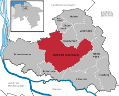

Coordinates 53°13′N 8°48′E / 53.21667°N 8.8°ECoordinates: 53°13′N 8°48′E / 53.21667°N 8.8°E Administration Country Germany State Lower Saxony District Osterholz Town subdivisions 10 districts Mayor Martin Wagener (SPD) Basic statistics Area 147 km2 (57 sq mi) Elevation 11 m (36 ft) Population 30,198 (31 December 2010)[1] - Density 205 /km2 (532 /sq mi) Other information Time zone CET/CEST (UTC+1/+2) Licence plate OHZ Postal code 27711 Area code 04791 Website www.osterholz-scharmbeck.de Osterholz-Scharmbeck is a town and the capital of the district of Osterholz, in Lower Saxony, Germany. Osterholz-Scharmbeck is situated in between the cities of Bremen and Bremerhaven.
Contents
Geography
Neighbouring places
- Bremen (22 km)
- Delmenhorst (31 km)
- Achim (37 km)
- Bremerhaven (39 km)
- Brake (40 km)
- Zeven (41 km)
- Bremervörde (43 km)
- Nordenham (46 km)
- Oldenburg (48 km)
- Rotenburg (50 km)
Division of the town
Official parts
- Freißenbüttel
- Garlstedt
- Heilshorn
- Hülseberg
- Ohlenstedt
- Pennigbüttel
- Sandhausen
- Scharmbeckstotel
- Teufelsmoor
Historical parts
- Ahrensfelde
- Altenbrück
- Altendamm
- Auf Dem Raden
- Auf Dem Rusch
- Bargten
- Bredbeck
- Buschhausen
- Büttel
- Feldhof
- Haslah
- Hinter Dem Horn
- Kattenhorn
- Lange Heide
- Lintel
- Muskau
- Myhle
- Niedersandhausen
- Ovelgönne
- Ruschkamp
- Settenbeck
- Vorwohlde
- Westerbeck
- Wiste
History
The town was first mentioned in 1043 as Scirnbeci. From 1180 on the Scharmbeck belonged to the Prince-Archbishopric of Bremen. The monastery in Osterholz was founded in 1182 and persisted until 1650, when Lower Saxony became mostly Protestant. In 1648 the Prince-Archbishopric was transformed into the Duchy of Bremen, which was first ruled in personal union by the Swedish and from 1715 on by the Hanoverian Crown. In 1823 the Duchy was abolished and its territory became part of the Stade Region in the Kingdom of Hanover.
In 1927 the two communities of Osterholz and Scharmbeck were merged under the name of Osterholz-Scharmbeck and in 1929 town privileges were granted.
Between 1978 and 1992 4200 soldiers of the US-army (2nd armored division fwd) were stationed and another 4000 family members resided in Osterholz-Scharmbeck.
Population Growth
- 1909: 6.060
- 1945: 12.500
- 1970: 23.500
- 1987: 24.150
- 2004: 31.145
- 2005: 31.255
Books
- Johann Segelken, Osterholz-Scharmbeck Heimatbuch, Verlag Saade, Osterholz-Scharmbeck 1938,1987
- Ernstheinrich Meyer-Stiens, Heimliche Hauptstraße, Osterholz-Scharmbeck 2000
- Meyer-Korte/Metzing, Osterholz-Scharmbeck: Picture and Development of a City, Osterholz-Scharmbeck 1979
References
- ^ "Bevölkerungsfortschreibung" (in German). Landesbetrieb für Statistik und Kommunikationstechnologie Niedersachsen. 31 December 2009. http://www1.nls.niedersachsen.de/statistik/html/parametereingabe.asp?DT=K1000014&CM=Bev%F6lkerungsfortschreibung.
External links
- Official site (German)
- Official site of village Freißenbüttel (German)
Axstedt | Grasberg | Hambergen | Holste | Lilienthal | Lübberstedt | Osterholz-Scharmbeck | Ritterhude | Schwanewede | Vollersode | Worpswede Categories:
- Towns in Lower Saxony
- Lüneburg region geography stubs


Wikimedia Foundation. 2010.