Kolhumadulhu Atoll

Kolhumadulhu Atoll

MaldiveAtoll
ImageExists=Yes
atoll


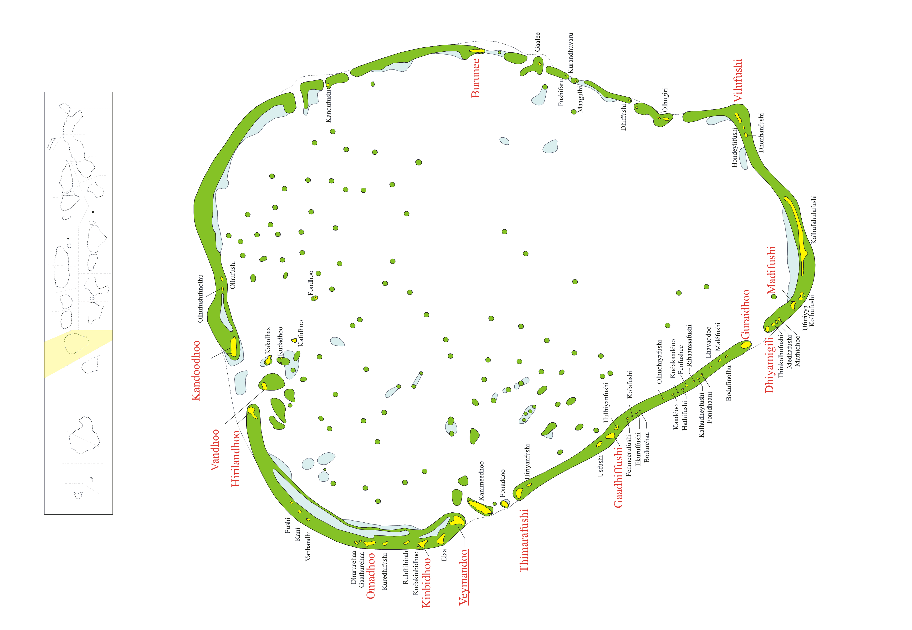
admin_name=Thaa Atoll
atoll_name=Kolhumadulu
location=2° 34' N and 2° 10' N| letter=N
abbreviation=Th (ތ)
capital=Veymandoo
population=13846
noofislands=66
inhabited_islands=13
atoll_chief= -
islands=Burunee Dhiyamingili Gaadhiffushi Guraidhoo Hirilandhoo Kandoodhoo Kinbidhoo Madifushi Omadhoo Thimarafushi Vandhoo Veymandoo Vilufushi
unislands=

Kolhumadulhu Atoll or Thaa is an is an administrative division of the Maldives. It corresponds to the natural atoll of the same name.

Traditionally, Maldivians call this atoll simply 'Kolhumadulhu', without adding the word 'Atholhu' at the end.

The waters surrounding this atoll are good fishing areas and some islands house fish processing plants.

Archaeology

There are important Buddhist archaeological remains in the island of Kimbidhoo, including a large ruined stupa. These were explored by the late Muhammad Ismail Didi. A report on the survey was published in the book "Divehi Tārīkhah Au Alikameh".

References

* "Divehi Tārīkhah Au Alikameh". Divehi Bahāi Tārikhah Khidmaiykurā Qaumī Markazu. Reprint 1958 edn. Malé 1990.
* "Divehiraajjege Jōgrafīge Vanavaru". Muhammadu Ibrahim Lutfee. G.Sōsanī.
* Romero-Frias, Xavier. "The Maldive Islanders, A Study of the Popular Culture of an Ancient Ocean Kingdom". Barcelona 1999.


Wikimedia Foundation. 2010.

Игры ⚽ Нужно сделать НИР?

Look at other dictionaries:

  • Atoll — For other senses of this word, see atoll (disambiguation). Satellite picture of the Atafu atoll in Tokelau in the Pacific Ocean. An atoll ( …   Wikipedia

  • Thaa Atoll — MaldiveAtoll ImageExists=Yes atoll admin name=Thaa Atoll atoll name=Kolhumadulu location=2° 34 N and 2° 10 N letter=N abbreviation=Th (ތ) capital=Veymandoo population=13846 noofislands=66 inhabited islands=13 atoll chief= islands=Burunee… …   Wikipedia

  • Nord-Malé-Atoll — Vorlage:Infobox Insel/Wartung/Höhe fehlt Nord Malé Atoll Das Nord Malé Atoll (im Zentrum) umgeben von Süd Malé Atoll, Gaafaru Atoll und Kaashidhoo Gewässer …   Deutsch Wikipedia

  • Süd-Malé-Atoll — Vorlage:Infobox Insel/Wartung/Höhe fehlt Süd Malé Atoll Das Süd Malé Atoll (im Süden), nördlich davon Nord Malé Atoll, Gaafaru Atoll und Kaashidhoo Gewässer …   Deutsch Wikipedia

  • Laamu Atoll — Atoll Summary Administrative name Laamu Atoll Atoll name …   Wikipedia

  • Gaafaru-Atoll — Vorlage:Infobox Insel/Wartung/Höhe fehlt Gaafaru Atoll Das Gaafaru Atoll (im Norden) umgeben von Nord und Süd Malé Atoll (im Süden) sowie Kaashidhoo (ganz nördlich) Gewässer …   Deutsch Wikipedia

  • Addu-Atoll — Vorlage:Infobox Insel/Wartung/Höhe fehlt Addu Atoll Gewässer Indischer Ozean Archipel Malediven Geographische Lage …   Deutsch Wikipedia

  • Ari-Atoll — Vorlage:Infobox Insel/Wartung/Höhe fehlt Ari Atoll Satellitenbild des Ari Atolls Gewässer Indischer Ozean Archipel …   Deutsch Wikipedia

  • Haddhunmathi Atoll — MaldiveAtoll ImageExists=Yes atoll admin name=Laamu Atoll atoll name=Haddhunmathi location=2° 08 N and 1° 47 N letter=O abbreviation=L (ލ) capital=Fonadhoo population=14313 noofislands=82 inhabited islands=12 atoll chief= Mohamed Naeem… …   Wikipedia

  • Rasdhoo-Atoll — Vorlage:Infobox Insel/Wartung/Höhe fehlt Rasdhoo Atoll Atolle der Malediven Gewässer Indischer Ozean Archipel …   Deutsch Wikipedia

Share the article and excerpts

Direct link
Do a right-click on the link above
and select “Copy Link”