- Copley Township, Knox County, Illinois
-
Copley Township — Township — Location in Knox County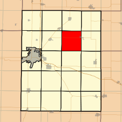 Knox County's location in Illinois
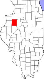
Coordinates: 41°01′09″N 90°09′20″W / 41.01917°N 90.15556°WCoordinates: 41°01′09″N 90°09′20″W / 41.01917°N 90.15556°W Country  United States
State  Illinois
County Knox Established November 2, 1852 Area – Total 35.47 sq mi (91.87 km2) – Land 35.04 sq mi (90.75 km2) – Water 0.43 sq mi (1.12 km2) 1.22% Elevation 810 ft (247 m) Population (2000) – Total 433 – Density 12.4/sq mi (4.8/km2) Time zone CST (UTC-6) – Summer (DST) CDT (UTC-5) ZIP codes 61414, 61428, 61448, 61467, 61485 GNIS feature ID 0428842 Copley Township is one of twenty-one townships in Knox County, Illinois, USA. As of the 2000 census, its population was 433[1]. In the 1850 report, the township was named Prince Albert Township. It was later named Richfield Township, and the name was changed to Copley Township on June 8, 1853.
Contents
Geography
According to the United States Census Bureau, Copley Township covers an area of 35.47 square miles (91.9 km2); of this, 35.04 square miles (90.8 km2) (98.78 percent) is land and 0.43 square miles (1.1 km2) (1.22 percent) is water.
Cities, towns, villages
- Victoria (west half)
Cemeteries
The township contains these four cemeteries: Martin, Old Scotch, Smith and Westfall.
Lakes
- Corn Crib Lake
- Little John Club Lake
- Long Lake
- Manson Heights Lake
- North Lake
- Peterson Lake
- Roundhouse Lake
- South Lake
School districts
- Rowva Community Unit School District 208
Political districts
- Illinois's 18th congressional district
- State House District 74
- State Senate District 37
References
- "Copley Township, Knox County, Illinois". Geographic Names Information System, U.S. Geological Survey. http://geonames.usgs.gov/pls/gnispublic/f?p=gnispq:3:::NO::P3_FID:0428842. Retrieved 2010-02-25.
- United States Census Bureau 2009 TIGER/Line Shapefiles
- United States National Atlas
External links

Ontario Township Walnut Grove Township Lynn Township Sparta Township 
Victoria Township  Copley Township

Knox Township Persifer Township Truro Township Municipalities and communities of Knox County, Illinois Cities 
Villages Altona | East Galesburg | Henderson | London Mills‡ | Maquon | Rio | St. Augustine | Victoria | Wataga | Williamsfield | Yates City
Townships Unincorporated
communitiesGhost town Etherly
Footnotes ‡This populated place also has portions in an adjacent county or counties
Categories:- Townships in Knox County, Illinois
- Galesburg micropolitan area


Wikimedia Foundation. 2010.