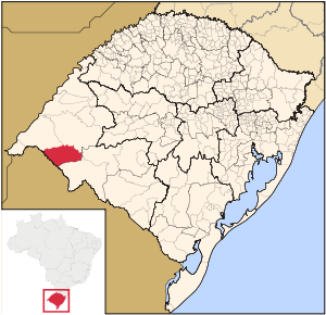
- Mato Queimado
-
Map 
Statistics State: Rio Grande do Sul Meso-region: Micro-Region: Cerro Largo Founded: April 8, 1875 Location: 28.357/28° 15' 21" S lat.
54.6158/54° 36' 57" W long.Population (2003):
- Total
- Change
- Density
1,939
-
N/ADistance from the capital: 489 km Website: www.matoqueimado.rs.gov.br Mato Queimado is a small Brazilian town located in the northwestern part of the state of Rio Grande do Sul. It has a population of 1,939 (2005). It is located 489 km west of the state capital of Porto Alegre and northeast of Alegrete.
Neighbouring municipalities
Other
Mato Queimado has a school or a collegiate, churches and a few squares and parks.
External links
- http://www.citybrazil.com.br/rs/matoqueimado/ (Portuguese)
- Map and Aerial photos:
- Coordinates: 28°15′21″S 54°36′57″W / 28.25583°S 54.61583°W
- Street maps: Street map from Mapquest, MapPoint or Google
- Satellite images and Aerial photos: Google
Categories:- Populated places in Rio Grande do Sul
- Rio Grande do Sul geography stubs
Wikimedia Foundation. 2010.
