Corbières (mountains)

Corbières (mountains)
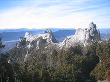
Puig de Bugarag, highest point in the Corberes range, the only foothill of the Pyrenees on their northern side.

The Corbières (Catalan language: Corberes) is a mountain range in the Pre-Pyrenees.

Geography

The Corbières are a mountain region in the Languedoc-Roussillon in southwestern France, located in the departements of Aude and Pyrénées-Orientales.

The River Aude borders the Corbières to the west and north, and the River Agly more or less to the south. The eastern border is the Mediterranean Sea. The eastern part of the Corbières bordering the Mediterranean and the Etangs is called the Corbières maritimes, and has a special kind of climate and typical vegetation (thermo-mediterranean vegetation) which cannot be found in the western part. The highest point of the Corbières is the Pic de Bugarach (1230 m).

See also

References

  • Christophe Neff : Les Corbières maritimes – forment-elles un étage de végétation méditerranéenne thermophile masqué par la pression humaine ? In: Eric Fouache (Edit.): The Mediterranean World Environment and History. IAG Working Group on Geo-archeology, Symposium Proceedings. Environmental Dynamics and History in Mediterranean Areas, Paris, Université de Paris – Sorbonne 24 – 26 avril 2002. Paris, 2003, 191 – 202, (Elsevier France, ISBN 2-84299-452-3).

Coordinates: 42°50′27″N 2°45′08″E / 42.84083°N 2.75222°E / 42.84083; 2.75222


Wikimedia Foundation. 2010.

Игры ⚽ Поможем написать курсовую

Look at other dictionaries:

  • Corbières (disambiguation) — Corbières may refer to: Corbières, municipality in Switzerland a commune in France: Corbières, Alpes de Haute Provence Corbières, Aude Corbières AOC, French wine appellation Corbières (mountains) mountain region in the Languedoc Roussillon in… …   Wikipedia

  • Mayronnes — Mayronnes …   Wikipedia

  • Montjoi, Aude — Montjoi …   Wikipedia

  • Leucate — French commune nomcommune=Leucate région=Languedoc Roussillon département=Aude arrondissement=Narbonne canton=Sigean insee=11202 cp=11370 maire=Michel Py mandat=2001 2008 intercomm=Corbières en Méditerranée longitude=3.0294 latitude=42.9105 alt… …   Wikipedia

  • Pic de Bugarach — Infobox Mountain Name = Pic de Bugarach Photo = Bugarach.jpg Caption = Elevation = convert|1230|m|ft|0 Range = Corbières Location = France Prominence = Coordinates = coord|42|51|49|N|2|22|45|E|region:FR type:mountain|display=inline,title Type=… …   Wikipedia

  • Route nationale 9 — The Route nationale 9, or RN 9, is a trunk road (nationale) in France between Moulins and the frontier with Spain. Contents 1 Reclassification 2 Route 2.1 Moulins to Clermont Ferrand (0 km to 103 km) …   Wikipedia

  • Catharism — Cathar redirects here. For other uses, see Cathar (disambiguation). The Good Men redirects here. For the Dutch house music duo, see Zki Dobre. Gnosticism This article is part of a series on …   Wikipedia

  • Aude — For other uses, see Aude (disambiguation). Aude   Department   …   Wikipedia

  • Pyrenees — Geobox|Range name=Pyrenees other name= es. Pirineos ca. Pirineus fr. Pyrénées oc. Pirenèus an. Perinés eu. Pirinioak etymology=Pyrene|etymology type=Named for image caption=Central Pyrenees country=Spain| country1=France| country2=Andorra unit=… …   Wikipedia

  • List of wine-producing regions — This list of wine producing regions catalogues significant growing regions where vineyards are planted. Wine grapes mostly grow between the 30th and the 50th degree of latitude, in both the Northern and Southern hemispheres. Grapes will sometimes …   Wikipedia

Share the article and excerpts

Direct link
Do a right-click on the link above
and select “Copy Link”