- Mappowder
-
Coordinates: 50°51′11″N 2°22′41″W / 50.853°N 2.378°W
Mappowder
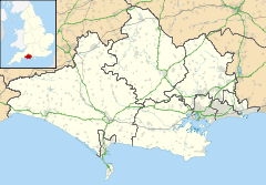
 Mappowder shown within Dorset
Population 137 OS grid reference ST735061 District North Dorset Shire county Dorset Region South West Country England Sovereign state United Kingdom Police Dorset Fire Dorset Ambulance South Western EU Parliament South West England List of places: UK • England • Dorset Mappowder is a village in north Dorset, England, situated in the Blackmore Vale nine miles south east of Sherborne. The village has a population of 137 (As of 2001[update]). The name of the village comes from mapuldor, Old English for 'maple tree'.[1] There is believed to have been a settlement at Mappowder since at least 1086.
The Church, dedicated to St Peter & St Paul, is Perpendicular and was built in the late 15th and 16th centuries. However, it includes features remaining from an earlier 12th century church. The chancel was expanded in 1868 by the Wingfield Digby family of Sherborne Castle, who owned the village in victorian times.
References
- ^ Gant, R., Dorset Villages,Hale, 1980, p73
External links
Coordinates: 50°51′11″N 2°22′41″W / 50.853°N 2.378°W
Categories:- Villages in Dorset
- Dorset geography stubs
Wikimedia Foundation. 2010.

