Florida State Road 399

Florida State Road 399

State Road 399 marker

State Road 399
Route information
Maintained by FDOT
Length: 28.33 mi (45.593 km)
Major junctions
West end: Parking lot in Fort Pickens
East end: US 98 / SR 30 in Navarre
Location
Counties: Escambia, Santa Rosa
Highway system

Florida State and County Roads
Interstate • US • SR (Pre-1945) • Toll • County

SR 396 SR 400

State Road 399 is a Florida State Road in Escambia and Santa Rosa, although in Santa Rosa County it is known as a county road. It is 28.33 miles (45.59 kilometers) long, mostly on Santa Rosa Island. It is an access road to Gulf Islands National Seashore. Along its entire route, it traversed into an area that the Longleaf Pines lie next to the sand dunes of the Gulf Of Mexico. The western terminus is at a parking lot at Fort Pickens. The eastern terminus is with an intersection of US 98–SR 30 in Navarre.

Route description

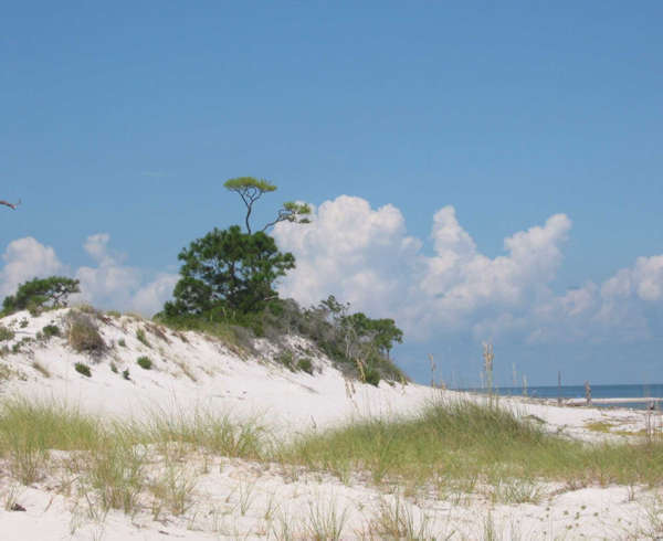
A photograph of Gulf Islands National Seashore off SR 399; Notice the Longleaf Pines on the left side of the picture touch the sand dunes

Beginning at the US 98–SR 30 in Navarre, it first heads north–south, traveling on the Navarre Bridge, which crosses Santa Rosa Sound from the mainland to Santa Rosa Island. The Navarre Bridge was a toll bridge with one cash and one Sunpass lane for southbound traffic until 2005 but it is now toll-free. In Pensacola Beach, the road splits, with the north–south causeway to US 98, and the other road leading to Fort Pickens, which is considered the main road. In Gulf Islands National Seashore, it ends as a cul-de-sac at a parking lot.

Note: U.S. roads are generally numbered under the assumed parameters that odd numbered roads run south-to-north, and even numbered roads run west-to-east direction in order to follow the order of their mileposts. However, this section of SR 399 runs almost exclusively west-to-east.


Wikimedia Foundation. 2010.

Игры ⚽ Поможем сделать НИР

Look at other dictionaries:

  • Florida State Road A19A — State Road A19A is a loop in the St. Petersburg, Florida, area that currently consists of the entirety of the north south SR 693 (66th Street), a stretch of SR 699 in and near St. Pete Beach, and the entirety of SR 682 (a part of the toll… …   Wikipedia

  • Florida — This article is about the U.S. state of Florida. For other uses, see Florida (disambiguation). State of Florida …   Wikipedia

  • U.S. Route 441 in Florida — This article is about the section of U.S. Route 441 in Florida. For the entire length of the highway, see U.S. Route 441. U.S. Highway 441 …   Wikipedia

  • Liste der State-, U.S.- und Interstate-Highways in Florida — Die Liste gibt eine Übersicht der State , U.S. und Interstate Highways in Florida. Inhaltsverzeichnis 1 State Routes 2 Interstate Highways 3 United State Routes …   Deutsch Wikipedia

  • National Register of Historic Places listings in Escambia County, Florida — Location of Escambia County in Florida This is a list of the National Register of Historic Places listings in Escambia County, Florida. This is intended to be a complete list of the properties and districts on the National Register of Historic… …   Wikipedia

  • South Florida metropolitan area — South Florida redirects here. For the university in Tampa, see University of South Florida. For that school s athletic program, see South Florida Bulls. Miami–Fort Lauderdale–Pompano Beach Common name: South Florida Larg …   Wikipedia

  • List of county roads in Pinellas County, Florida — County road shields used in Florida Highway names County: County Road X (CR X) System links Florida State a …   Wikipedia

  • List of State Routes in New York — Standard state route shields in different parts of New York. Highway names Interstates …   Wikipedia

  • County Road 402 (Brevard County, Florida) — Infobox road marker state=FL County highway name= name notes= type=Brevard route=402 alternate name= maint= section= length mi=10.6 length round=1 length ref=Florida Department of Transportation, [http://www.dot.state.fl.us/planning/statistics/gis… …   Wikipedia

  • Wildwood, Florida — Infobox Settlement official name = Wildwood, Florida other name = native name = nickname = settlement type = City motto = imagesize = image caption = flag size = image seal size = image shield = shield size = image blank emblem = blank emblem… …   Wikipedia

Share the article and excerpts

Direct link
Do a right-click on the link above
and select “Copy Link”