- Transport in Dublin
-
Dublin Region Railway Network
DART and Commuter lines in red
Luas lines in blue (extensions under construction are in light blue)Legend

Dundalk 
Drogheda 
Laytown Gormanston Balnbriggan Skerries Rush and Lusk Donabate Malahide Portmarnock 

Howth Sutton Bayside 

Howth Junction Kilbarrack Raheny Harmonstown Killester Clontarf Road Longford Enfield Kilcock Maynooth Leixlip Louisa Bridge Leixlip Confey Clonsilla Coolmine Castleknock Phoenix Park Ashtown Broombridge 


Drumcondra Docklands 


The Point 
Spencer Dock Mayor Square George's Dock 

Dublin Connolly 


Busáras Abbey Street Saint Stephen's Green 
Harcourt Charlemont Ranelagh Beechwood Cowper Milltown Windy Arbour Dundrum Balally Kilmacud Stillorgan Sandyford Central Park Glencairn The Gallops Leopardstown Valley Ballyogan Wood Racecourse Carrickmines Brennanstown Laughanstown Cherrywood Bride's Glen 
Jervis Four Courts Smithfield Museum Dublin Heuston 
Cherry Orchard and Parkwest Clondalkin/Fonthill Adamstown Hazelhatch and Celbridge Sallins and Naas Newbridge Kildare 
James's Fatima Rialto Suir Road Goldenbridge Drimnagh Blackhorse Bluebell Kylemore Red Cow Kingswood Belgard Cookstown Hospital Tallaght Tara Street Dublin Pearse Grand Canal Dock Lansdowne Road Sandymount Sydney Parade Booterstown Blackrock Seapoint Salthill and Monkstown 
Dún Laoghaire Mallin Sandycove and Glasthule Glenageary Dalkey Killiney Shankill Bray Greystones Kilcoole Wicklow Rathdrum Arklow This article deals with transport in the Greater Dublin Area centered on the city of Dublin in Ireland.
Contents
Public transport
There are a number of modes of public transport in the Greater Dublin area run by a number of transport operators, most of them state or quasi-state entities. Public transport in Dublin is overseen by the Dublin Transportation Office. It has undergone expansion in recent years, and the Irish Government plans to invest heavily[1] in the system under the Transport 21 plan.
Dublin's transit system currently utilises electrified suburban trains, diesel commuter rail, trams and an extensive bus network to provide service to the population of the Greater Dublin Area.
The Railway Procurement Agency is responsible for establishing an integrated ticketing system for use throughout Dublin City, but progress has been slow on the project.[2] A Dublin Transportation Authority will soon be created to make public transportation in Dublin more cohesive and better integrated.[3]
Rail
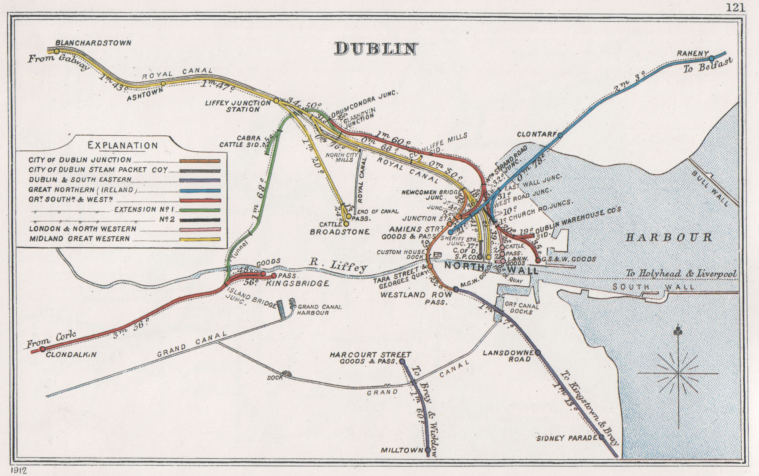
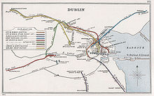 1912 rail network map
Rail services in Dublin include the five lines of the Dublin Suburban Rail operated by Iarnród Éireann, Ireland's national railway system.[4] One of these is the electrified Dublin Area Rapid Transit (DART). Passenger traffic to other Irish cities is also operated by Iarnród Éireann from Connolly and Heuston stations. Heuston Station connects with the south and west (Ballina, Westport, Galway, Ennis, Limerick, Tralee, Cork and Waterford lines) and Connolly Station serves Sligo, Wexford and Belfast.
Commuter rail
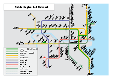 Dublin rail network mapMain article: Commuter (Irish Rail)
Commuter rail in Dublin operates on 4 lines. All commuter rail is operated by Irish Rail diesel multiple units.
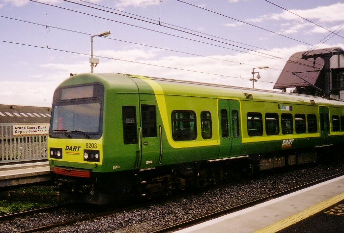
 A train entering Pearse Station
The Northern Commuter service extends from Dublin City Centre to Dundalk, the Kildare Commuter service extends west from Heuston Station to stations as far as Portlaoise, Maynooth Commuter service extends from Dublin City as far as Longford and the Southern Commuter service runs from Gorey to Dublin city.[5] All commuter rail service runs via Dublin City Centre, and there is no orbital service of any kind.
The Maynooth commuter service is the most recent to have benefited from significant improvement with the March 2007 opening of the new Docklands railway station in Dublin City Centre, which has allowed for more capacity on the route, not previously possible due to overcrowding at Connolly Station.[6]
Significant improvements on the Kildare line are also planned which involve doubling trackage on the line (to four tracks) to allow local traffic to move independently of higher speed intercity trains.[7]
DART
Main article: Dublin Area Rapid Transit
The Dublin Area Rapid Transit (DART) is part of the suburban railway network and consists of one line and a spur running primarily along the coastline of Dublin Bay, from Greystones in County Wicklow to Howth and Malahide in northern County Dublin. The DART line is the only electrified railway in the country and over 80,000 people use it every day making it arguably Ireland's greatest public transport success story.[8]
The DART system was opened in 1984 and, like all other rail service in Dublin, it suffers from extreme overcrowding at rush hours, but current expansion plans will increase its capacity by 40% to 22,800 passengers by 2009.[9][10].
Transport 21 plans are also underway to greatly expand the DART suburban railway network by boring a tunnel through Dublin City Centre allowing the creation of two separate DART lines. Each will run from the northwest & southwest of the city, through the city centre and then extend south and north respectively. This plan is made possible with the Dublin Interconnector rail project, boring a tunnel under the city centre that will join Heuston Station with Pearse Station and a newly constructed Docklands station, via St Stephen's Green. The railway lines from Heuston toward Kildare (Hazelhatch) and from the city centre to Maynooth will be electrified, and the old line to Navan reopened and electrified. This will allow the creation of two separate but inter-connecting DART lines: one running from the north west (Dunboyne/Maynooth) through the city-centre to the southeast (Bray); and one running from south-west (Hazelhatch) through the city centre to the northeast (Howth/Balbriggan).
Light rail
Dublin tram system
The Dublin tram system was a tram system in operation from 1865 until its closure in 1959.
Luas
Main article: Luas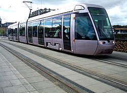 Luas Tram
A two-line light rail tram network called the Luas, named after the Irish word for "speed", opened in 2004 and has proved popular in the areas it serves - although the lack of a link between the two lines is widely criticised. The Transport 21 plan calls for the joining of the two lines in the city centre as well as seven other expansion projects. It is estimated that around 90,000 people use the Luas daily.
In 2006, the Railway Procurement Agency announced that the Luas system reached profitability ahead of schedule, after only a year of operation. It is now the only mass transit in the country to operate without Government assistance, and among the few in Europe.
Currently[update], the two unconnected on-street light rail lines are:
There are currently seven projects for adding new Luas lines, as well as a spur currently being added to the Red Line.
Metro
Main article: Dublin MetroAs of 2006[update], the Dublin Metro is a planned two-line rapid transit (underground) system set out in the Irish government's 2005 Transport 21 plan.
The North line will run from St. Stephens Green to Swords via Dublin Airport and the City's Northern Suburbs, While the Metro West line will be an orbital route linking fock sheed up Tallaght and Dublin Airport via Clondalkin, Lucan, Blanchardstown, Finglas and Ballymun. It will link up all the major commuter links (Rail, DART, Luas, Metro and Bus routes) that lead North, West and Southwest of the City.
Bus
Main article: Dublin BusThe state-owned Dublin Bus operates an extensive bus network of nearly 200 radial, cross-city and peripheral routes in the Greater Dublin Area, which constitutes the bulk of the area's public transport system. Daytime routes are identified by number and sometimes suffixed with a letter (e.g. 40, 40A, 40B, 40C, 40D) and 24 "Nitelink" overnight services which run on Monday to Saturday nights are identified by a number suffixed with "N" (e.g. 40N). Apart from some tourist buses, all Dublin Bus' services are one-person operated, and daytime fares are determined by the number of fare stages travelled through — fares are payable in coin and only the exact fare is acceptable — if passengers overpay, they are issued "change tickets" which must be presented at the Dublin Bus office in O'Connell Street to be converted to cash. Alternatively, various pre-paid tickets and passes can be bought from Dublin Bus or its agents, and are processed by a validating machine on the right of the entrance door of the bus. Nitelink buses charge a flat fare of 5 Euro [11] regardless of the distance travelled. A number of smaller other bus companies provide services such as airport buses as well.
The Bus Arrival Information Service is being rolled out across Dublin, and provides real time estimates of bus arrivals at each stop, based on GPS locations of buses.
Under Transport 21, Dublin Bus's passenger-carrying capacity will increase by 60% in phases by 2015, through new and replacement bus acquisition.
Intercity bus routes are operated by state-owned Bus Éireann largely from Busáras, the central bus depot and the busiest in Ireland, near Connolly railway station. There are frequent departures to all areas of the Island. A limited number of intra- and inter-city routes are run by private entities.
As well as the usual complement of open-top Bus Tours run by Dublin Bus around Dublin city, a Ghost Bus Tour runs at night through some of the supposedly haunted places in the city.
BlueLine
BlueLine Legend
St Vincent's (  Sydney Parade)
RTÉ UCD Main Gate UCD Central Roebuck Road Mount Anville Goatstown Kilmacud 


Stillorgan/Sandyford 
Sandyford Central 
In 2010, a proposal was announced for a new Bus rapid transit route for SE Dublin, called BlueLine. This is being promoted by Dún Laoghaire-Rathdown County Council and a number of major employers in the area as an inexpensive way of improving the public transport in that area of the city. The proposal would see a scheme similar to that of the Nantes Busway, with long articulated buses with multiple entrances, resembling LRT vehicles, operating in segregated bus lanes, with LRT like raised platforms at each stop. The BlueLine is planned to connect with the Luas at Sandyford and the DART at Sydney Parade, with stops serving St. Vincent's University Hospital, University College Dublin, the RTÉ studios and the Sandyford Industrial Area. The county manager has stated a preference for the RPA to be responsible for running the scheme.[12]
Roads
Main article: Streets and squares in DublinMotorways
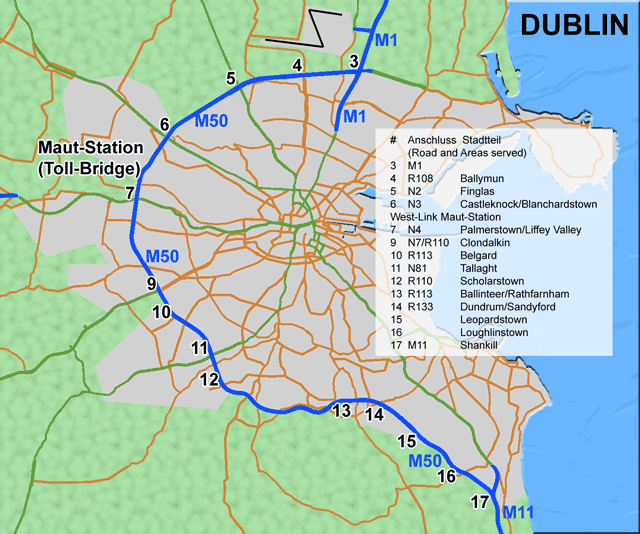
See also: Roads in Ireland Map of M50 motorway
Greater Dublin is directly served by several motorways. The M50 motorway, arguably the most important to the city is an intra-area thoroughfare that is a partial ring road around the southern, western, northern and north eastern edges of the city. Construction of the M50 took almost 20 years, with the final section opening in June 2005. A court case regarding the destruction of medieval ruins at Carrickmines Castle delayed the final completion of the route.
On the 20 December 2006 the Port Tunnel which carries traffic from the port and onto the motorway close to the M50/M1/N52 interchange was opened as the first step of an eastern bypass to Dublin, making the M1 junctions 1 to 3 now the M50. Though originally intended to be a two-lane single-bore system catering specifically to HGV traffic, the Port Tunnel has been built to motorway standard as two separate tunnels to cater for all traffic (although HGV traffic is not tolled). The tunnels are deeper than originally planned to reduce disturbance to residential areas, and were built one kilometre longer and with more ancillary works to facilitate this. From February As of 2007[update], 5-axle vehicles are prohibited from travelling within the city centre cordon between 7:00 and 19:00 Monday to Sunday (unless the vehicle has obtained a valid permit for necessary deliveries from the Dublin City Council HGV website).
The M50 originally had two traffic lanes going either direction but now it has been increased it to three on the southern section, and four lanes each way between junctions on the Northern and Western sections. The National Roads Authority also increased capacity at many of the motorway's busiest junctions by building triple-grade interchanges instead of the lower capacity roundabouts and crossroads that were in place. The toll at the West-Link which caused huge tailbacks was demolished and replaced by a tag tolling system. This reduced tailbacks greatly.
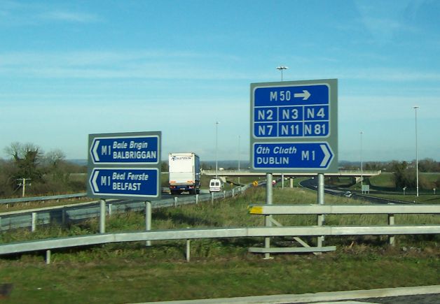
 M1 roundabout at Dublin Airport
The M1, M2, M3, M4, M6,M7, M8,M9, and M11 motorways all serve the Greater Dublin Area.
Orbital routes
Dublin is surrounded by what have been termed by Dublin City Council as an inner and outer orbital route. The inner orbital route runs roughly around the heart of the Georgian city from St. Stephen's Green to Mountjoy Square and from the King's Inns to St Patrick's Cathedral. The outer orbital route runs largely along the natural circle formed by Dublin's two canals, the Grand Canal and the Royal Canal, as well as the North and South Circular Roads.
Additionally, another orbital route is being developed in the west of the City, and has been completed between the N7 and the N4 which provides an alternative to the heavily congested M50. It is planned to extend this to Tallaght, and eventually Northwards to Blanchardstown, and then on to Swords in North Dublin.
The National Roads Authority has also undertaken a study into the development of another M50 style Orbital Motorway that is being termed the "Leinster Outer Orbital route". It is planned to run from Drogheda Via Navan to Naas, Thus linking the M1, M2, M3, M4, M7 and M9 and Via those routes, the M6 and M8. This will alleviate much pressure from the M50 by taking non Dublin bound traffic completely out of the Dublin Road Network, as well as providing links between Dublin's Satellite and Commuter Towns, and other parts of Leinster.
Dublin Bikes
Main article: Dublin BikesDublin Bikes is a public bicycle rental scheme which has been operated in the city of Dublin since 2009. The scheme uses 450 French-made[13] unisex bicycles with a silver colour.[14] Dublin was the 17th city to begin using this scheme (predecessors include Copenhagen, Lyon, and Paris), though Dublin City Council suggested the Dublin launch was better.[14][15] The scheme is sponsored by JCDecaux.[16]
Car Sharing
A car sharing scheme commenced service during summer 2010. Several bases are planned around the city, Pleasants Street, off Camden Street is the first in operation with Rathmines and Smithfield to follow. The council supported service is managed by Mendes GoCar.[17]
Water traffic
Canals
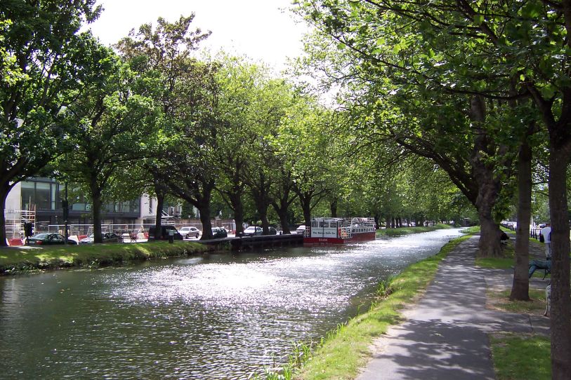
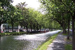 The Grand Canal at Wilton Terrace
Dublin has two major canals, the Royal Canal and the Grand Canal in the northern and southern portions of the city respectively. The canals were originally built for freight and passenger transportation from the River Liffey at Dublin to the River Shannon in western Ireland. Today, the canals, run by Waterways Ireland, are fully operable but are used only occasionally for pleasure craft.
Ports
Dublin is served by two ports which both handle a mixture of passengers and freight to and from the UK. Dún Laoghaire port to the south of Dublin and Dublin Port which is situated just outsite the city centre.
Dún Laoghaire
Dún Laoghaire harbour is situated about 13.6 km from Dublin city centre.[18] It is easily accessible by road, rail, bus and of course by sea. Four Dublin Bus routes serve the port, including one direct from Dublin Airport. The DART rail system serves Dún Laoghaire Harbour from both Malahide and Howth in the north which en route to Dún Laoghaire goes straight the city centre. It is also served from Greystones in the south. Stena Line operates four daily sailings from Dún Laoghaire Harbour to Holyhead in Wales by means of the Stena HSS, a high speed ferry service.[19] Sailing time is generally around 90 mins.
Dublin Port
Dublin Port is situated closer to the city centre than Dún Laoghaire Harbour. It operates up to 18 daily sailings to the UK and the continent. Locations include Liverpool, Holyhead and Birkenhead[20]. The port carried 30.9 million tonnes of goods and passengers in 2007. 19.9 million tonnes of this was made up of material being imported and 10.9 million tonnes was material for export.[21] The port also handles aboout 1.3 million tourists yearly.[22] The port is only minutes from Dublin city centre and is accessed by a number of Dublin Bus routes. Taxis are also an easy way to get to the port.[23]
It is likely that in the near future, a new Deep water Port at Bremore near Balbriggan in North Dublin will be developed to take pressure off Dublin port, and possibly release much of its lands for Urban development.
Air transport
Main article: Dublin Airport Dublin Airport Terminal 1 entrance
Both domestic and international air traffic in Dublin is served by Dublin Airport which is located 10 km north of Dublin city centre in Collinstown and is accessible by car or bus. It is the busiest airport by far in Ireland, registering almost 24 million passengers in 2008, making it the 11th busiest airport in Europe with flights to other airports in Ireland, Europe, North America, Africa and the Middle East. The route to London from Dublin Airport is the busiest air corridor in the European Union.[24]
References
- ^ RTÉ Business: Rail major part of huge transport plan
- ^ ITS - Public Transport Integrated Ticketing System, RPA Railway Procurement Agency Ireland LUAS
- ^ RTÉ Business: New chairman for Railway Procurement Agency
- ^ Irish Rail - Iarnród Éireann - train tickets, train times, Ireland rail travel information
- ^ Irish Rail - Iarnród Éireann - train tickets, train times, Ireland rail travel information
- ^ RTÉ News: New railway station opens in Dublin city
- ^ http://www.iarnrodeireann.ie/projects/introduction.asp
- ^ Save the Tara/Skryne(Gabhra) Valley from the destruction posed by the proposed construction of the M3 Motorway
- ^ Dáil Éireann - Volume 560 - 06 February, 2003 - Railway Safety Bill 2001: Second Stage (Resumed)
- ^ http://www.iarnrodeireann.ie/projects/pdf/page9and10.pdf
- ^ http://www.dublinbus.ie/en/Your-Journey1/Timetables/Nitelink-Services/
- ^ "First bus rapid-transit route for Dublin would link Sydney Parade and Sandyford". The Irish Times. October 2010. http://www.irishtimes.com/newspaper/ireland/2010/1009/1224280701137.html?sms_ss=twitter&at_xt=4cb0a04fbc1d442d,0. Retrieved 2010-10-11.
- ^ Rosita Boland (13 June 2009). "Dublin's long-awaited wheel deal on track for September roll-out". The Irish Times. http://www.irishtimes.com/newspaper/weekend/2009/0613/1224248748656.html?via=mr. Retrieved 10 March 2010.
- ^ a b "2,000 join Dublin bicycle scheme". RTÉ. 13 September 2009. http://www.rte.ie/news/2009/0913/bicycles.html. Retrieved 10 March 2010.
- ^ "Gormley hails Dublin bike scheme". The Irish Times. 13 September 2009. http://www.irishtimes.com/newspaper/breaking/2009/0913/breaking7.html. Retrieved 10 March 2010.
- ^ Andrew Phelan (14 September 2009). "Free bikes scheme is hit by vandals -- after just one day". Evening Herald. http://www.herald.ie/national-news/city-news/free-bikes-scheme-is-hit-by-vandals--after-just-one-day-1885887.html. Retrieved 10 March 2010.
- ^ http://www.gocar.ie
- ^ Google Maps
- ^ Stena Line Ferry Service Dún Laoghaire Harbour Company
- ^ Dublin Port Home Page
- ^ Individual Article
- ^ Dublin Port Company - About - Corporate Information
- ^ Getting to Dublin Port
- ^ Dublin-London busiest air traffic route within EU Irish Examiner, 31 March 2003
See also
External links
- Map of Dublin orbital routes
- Dublin Bus
- Dublin Suburban Rail and DART website
- Dublin Suburban Rail and DART map
- LUAS website
- LUAS Map
Transport in Dublin Air Rail Tram*Road Bus corridorsR101 · R102 · R103 · R104 · R105 · R106 · R107 · R108 · R109 · R110 · R111 · R112 · R113 · R114 · R115 · R116 · R117 · R118 · R119 · R120 · R121 · R122 · R123 · R124 · R125 · R126 · R127 · R128 · R129 · R130 · R131 · R132 · R133 · R134 · R135 · R136 · R148 · R156 · R403 · R445 · R761 · R810 · R817 · R821 · R822 · R824 · R825 · R826OtherWater CanalsPortsAgencies *=Tram systems no longer run. Information in parentheses shows the operator(s)Categories:- Transport in Dublin (city)
- Transport in County Dublin
- Public transport in the Republic of Ireland


Wikimedia Foundation. 2010.