- Junqueirópolis
Infobox City
official_name = Junqueirópolis
imagesize = 250px
image_caption = Junqueirópolis
image_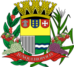

mapsize = 250px
map_caption = Location of Junqueirópolis
subdivision_type = Country
subdivision_type1 = Region
subdivision_type2 = State
subdivision_name =Brazil
subdivision_name1 = Southeast
subdivision_name2 = São Paulo
leader_title = Prefeitura de Junqueirópolis
leader_name = Osmar Pinatto
(until 2008)
area_note = 1260
area_total_km2 = 5
population_as_of = 2004
population_total =
population_density_km2 = 28.3
population_total =
population_metro = 16644
timezone = UTC-3
utc_offset =
timezone_DST =
utc_offset_DST =
latd = 21|latm= 30|lats= 53|latNS=S
longd = 51|longm=26|longs= 01|longEW=W
elevation_ft =
website = [http://www.junqueiropolis.sp.gov.br/ Prefeitura Municipal de Junqueirópolis (in Portuguese)]
footnotes =|Junqueirópolis is the name of a
city and the surrounding municipality in the western region of the state of São Paulo,Brazil .The population as of 2004 was 16,644. Junqueirópolis has an area of 584.48 km² (5 km² of which is city) and an elevation of 421 m. "Rio do Peixe" (Fish River) and "Rio Aguapeí" (Aguapeí River) are major
waterway s of the region. [http://www.junqueiropolis.sp.gov.br/] Prefeitura Municipal de Junqueirópolis (in Portuguese)] [http://www.junqueiropolis.sp.gov.br/aspectosgeograficos.php] Aspectos Geográficos de Junqueirópolis (in Portuguese)]History
At the start of the 20th century this area was largely unexplored and undeveloped. It was not until 1941 that the "Companhia Paulista de Estrada de Ferro" (São Paulo Locomotive Company) ran
railroad tracks through this remotehinterland . [http://www.junqueiropolis.sp.gov.br/historia.php] História de Junqueirópolis (in Portuguese)]Over the next few years Alvaro de Oliveira Junqueira, a wealthy inhabitant of the city of
São Paulo , began buying up land here upon which he establishedcoffee plantation s. On 1 November 1944 the municipal division of "Patrimônio de Junqueira" (Junqueira'sPatrimony ) was established andland development proceeded as lots were sold to investors.Horácio Cajado de Oliveira, Enrique Coutinho and Jose Amatruda were among those that settled here during this period. Another early settler was Torataro Takitami, a representative of the country's growing
Japanese Brazilian population.Junqueirópolis was officially founded on 14 June 1949. The
place name has been formed by joining Junqueira'ssurname with theGreek language -derivedsuffix "-polis " meaning "city".Agriculture
Outside the urban area, Junqueirópolis is a hilly, agricultural region that produces valuable
crop s that thrive in asubtropical climate . For this reason the municipality promotes itself as "Cidade Verde", "Green City".Among the
fruit s grown here,acerola is important enough to the local economy that Junqueirópolis has anothernickname -- "Capital da Acerola", the "Acerola Capital". In the 1998-1999 season Junqueirópolis produced 2,450 tons of this fruit. The predominant type of acerola produced here is the "Olivier", a variety that is packed with theVitamin C (1.200mg/100ml of juice and 1.400mg/100g of pulp) for which this plant is primarily cultivated and can be cultivated with littlepesticide .Junqueirópolis is also known for its
grape s. Among the most widely-cultivated varieties of grape in Junqueirópolis are Itália, Benitaka, Brazil and Ruby. Grapes from this region are made intotable wine s of excellent quality.Other major crops grown in Junqueirópolis are
maize ,cotton , and coffee. The importance of produce production to this region is demonstrated in the depiction of the municipalcoat of arms shown above which has been illustrated with acerola, grapes,sugar cane , etc. [ In heraldic terms, the produce shown in this depiction of Junqueirópolis' municipal coat of arms does not form an actual component of thearmorial achievement and is considered mere extraneous decoration]Penitentiary
The penitentiary in Junqueirópolis was the site of some of the violence of 2006 that swept the prisons of São Paulo state and involved deadly clashes between
Primeiro Comando da Capital (aprison gang ) andPolícia Militar do Estado de São Paulo (the state police). [ [http://seattletimes.nwsource.com/html/nationworld/2003012520_brazil23.html] "Seattle Times ", "Jails can't contain Brazil's gangs", Tuesday, May 23, 2006]References


Wikimedia Foundation. 2010.