- Creek Township, DeWitt County, Illinois
-
Creek Township — Township — Location in DeWitt County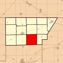 DeWitt County's location in Illinois
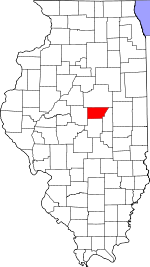
Coordinates: 40°05′27″N 88°51′20″W / 40.09083°N 88.85556°WCoordinates: 40°05′27″N 88°51′20″W / 40.09083°N 88.85556°W Country  United States
State  Illinois
County DeWitt Established November 2, 1858 Area - Total 36.88 sq mi (95.53 km2) - Land 35.46 sq mi (91.84 km2) - Water 1.42 sq mi (3.69 km2) 3.86% Elevation 712 ft (217 m) Population (2000) - Total 402 - Density 11.3/sq mi (4.4/km2) Time zone CST (UTC-6) - Summer (DST) CDT (UTC-5) ZIP codes 61727, 61735, 61750, 61882 GNIS feature ID 0428853 Creek Township is one of thirteen townships in DeWitt County, Illinois, USA. As of the 2000 census, its population was 402[1]. The township contains the east half of Weldon Springs State Park.
Contents
Geography
According to the United States Census Bureau, Creek Township covers an area of 36.88 square miles (95.5 km2); of this, 35.46 square miles (91.8 km2) (96.14 percent) is land and 1.42 square miles (3.7 km2) (3.86 percent) is water.
Unincorporated towns
Cemeteries
The township contains these two cemeteries: Lisenby and Rose.
Airports and landing strips
- Martin RLA Airport
School districts
- Argenta-Oreana Community Unit School District 1
- Clinton Community Unit School District 15
- Deland-Weldon Community Unit School District 57
- Maroa-Forsyth Community Unit School District 2
Political districts
- Illinois's 15th congressional district
- State House District 87
- State Senate District 44
References
- "Creek Township, DeWitt County, Illinois". Geographic Names Information System, U.S. Geological Survey. http://geonames.usgs.gov/pls/gnispublic/f?p=gnispq:3:::NO::P3_FID:0428853. Retrieved 2010-07-06.
- United States Census Bureau 2009 TIGER/Line Shapefiles
- United States National Atlas
External links

Clintonia Township Harp Township DeWitt Township Texas Township 
Nixon Township  Creek Township

Maroa Township, Macon County Friends Creek Township, Macon County Municipalities and communities of DeWitt County, Illinois County seat: Clinton Cities 
Villages DeWitt | Kenney | Wapella | Waynesville | Weldon
Townships Unincorporated
communitiesBirkbeck | Bucks | Carle Springs | Fullerton | Hallsville | Jenkins | Lane | Midland City | Ospur | Parnell | Rowell | Solomon | Tabor | Tunbridge | Watkins‡ | Weedman‡
Footnotes ‡This populated place also has portions in an adjacent county or counties
Categories:- Townships in DeWitt County, Illinois


Wikimedia Foundation. 2010.