- Nukufetau
-
This article is about atoll in Tuvalu. For the islet with a similar name in Wallis and Futuna, see Nukufetao.
Nukufetau — Atoll — Nukufetau atoll from space Location in Tuvalu
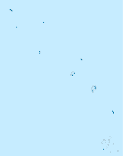
 Nukufetau
Coordinates: 08°00′S 178°30′E / 8°S 178.5°ECoordinates: 08°00′S 178°30′E / 8°S 178.5°E Country Tuvalu Population (2002) - Total 586 Nukufetau is an atoll that is part of the nation of Tuvalu. The atoll was claimed by the US under the Guano Islands Act some time in the 19th century and was ceded in a treaty of friendship concluded in 1979 and coming into force in 1983. It has a population (2002 census) of 586 and consists of at least 33 isles:
- Faiava Lasi
- Fale
- Funaota
- Kongo Loto Lafanga
- Lafanga
- Matanukulaelae
- Motufetau
- Motulalo
- Motuloa (north of Nukufetau)
- Motuloa (south of Nukufetau)
- Motumua
- Niualuka
- Niuatui
- Oua
- Sakalua
- Savave
- Teafatule
- Teafuaniua
- Teafuanonu
- Teafuone
- Temotuloto
- and at least 12 other islands
The biggest island is Motulalo. Savave has a village. The junior school is Tutasi Primary School.
Contents
History
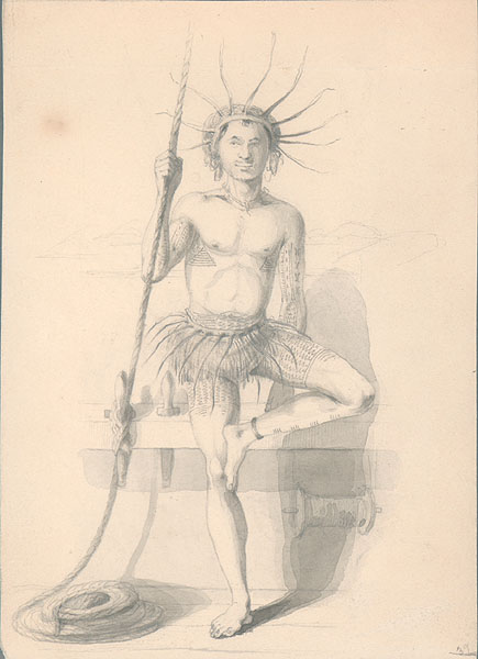
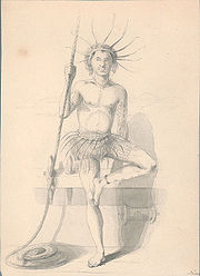 Tuvaluan man in traditional costume drawn by Alfred Agate in 1841 during the United States Exploring Expedition.
 A man from the Nukufetau atoll, drawn by Alfred Agate in 1841.
Arent Schuyler de Peyster, of New York, captain of the armed brigantine or privateer Rebecca, sailing under British colours,[1] passed through the southern Tuvalu waters in May 1819 sighting Nukufetau.[2] In 1820 the Russian explorer Mikhail Lazarev visited Nukufetau as commander of the Mirny.[3] [4]
The United States Exploring Expedition under Charles Wilkes visited Nukufetau in 1841.[5]
Louis Becke, who later became a writer, operated a store on Nukufetau from February 1881 to August 1881.[6] Becke later wrote a story about a fishing expedition: The Fisher Folk Of Nukufetau[7]
The population of Nukufetau from 1860-1900 is estimated to be 250 people.[8] [9]
Notable local person
A notable local person is Saufatu Sopoanga, Prime Minister of Tuvalu 2002-2004, who represented Nukufetau in the Parliament of Tuvalu for a number of years.
See also
- List of Guano Island claims
References
- ^ Miscellanies: by an officer, Volume 1, Ch. LXXX By John Watts De Peyster, A.E. Chasmer & Co. (1888)
- ^ Laumua Kofe, Palagi and Pastors, Tuvalu: A History, Ch. 15, Institute of Pacific Studies, University of the South Pacific and Government of Tuvalu, 1983
- ^ Keith S. Chambers & Doug Munro, The Mystery of Gran Cocal: European Discovery and Mis-Discovery in Tuvalu, 89(2) (1980) The Journal of the Polynesian Society, 167-198
- ^ Laumua Kofe, Palagi and Pastors, Tuvalu: A History, Ch. 15, Institute of Pacific Studies, University of the South Pacific and Government of Tuvalu, 1983
- ^ Tyler, David B. - 1968 The Wilkes Expedition. The First United States Exploring Expedition (1838-42). Philadelphia: American Philosophical Society
- ^ 'Louis Beck, Adventurer and Writer', Chapter 8, Rascals in Paradise, James A. Michener and Arthur Grove Day, Secker and Warburg (1957)
- ^ http://www.readbookonline.net/readOnLine/22405/
- ^ W.F. Newton, The Early Population of the Ellice Islands, 76(2) (1967) The Journal of the Polynesian Society, 197-204.
- ^ Richard Bedford, Barrie Macdonald & Doug Monro, Population Estimates for Kiribati and Tuvalu (1980) 89(1) J. of the Polynesian Society 199
Islands and atolls of Tuvalu Islands 
Atolls Islets of Funafuti Amatuku • Avalau • Falaoigo • Fale Fatu • Fatato • Fongafale • Fuafatu • Fuagea • Fualefeke • Fualopa • Funafala • Funamanu • Luamotu • Mateika • Motugie • Motuloa • Mulitefala Nukusavalevale • Papa Elise • Pukasavilivili • Te Afuafou • Te Afualiku • Tefala • Telele • Tengasu • Tepuka • Tepuka Vili Vili • Tutanga • VasafuaIslets of Nanumea Islets of Nui Fenua Tapu • Telikiai aka Meang • Motupuakaka • Pakantou • Piliaieve • Pongalei • Talalolae • Tokinivae • UnimaiIslets of Nukufetau Faiava Lasi • Fale • Funaota • Kongo Loto Lafanga • Lafanga • Matanukulaelae • Motufetau • Motulalo • Motuloa (north of Nukufetau) • Motuloa (south of Nukufetau) • Motumua • Niualuka • Niuatui • Oua • Sakalua • Savave • Teafatule • Teafuaniua • Teafuanonu • Teafuone • TemotulotoIslets of Vaitupu Categories:- Atolls of Tuvalu
- Islands claimed under the Guano Islands Act
- Nukufetau
- Tuvalu geography stubs


Wikimedia Foundation. 2010.