- Niulakita
-
Niulakita — Island — Location in Tuvalu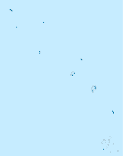
 Niulakita
Coordinates: 10°45′S 179°30′E / 10.75°S 179.5°ECoordinates: 10°45′S 179°30′E / 10.75°S 179.5°E Country Tuvalu Elevation 4.6 m (15 ft) Population (2002) - Total 35 Main article: TuvaluNiulakita is the southernmost reef island, which is a district of Tuvalu, and the name of the only village on this island. The junior school is Lotoalofa Primary School.
Contents
Geographical features
Niulakita consists of one island. It was bought by the United Kingdom in 1944 to decrease the population density, and has a population (2002 census) of 35. There are four ponds or lakes and the village has a maneaba (a village hall or community hall) in Tuvalu. There is one on each isle and they serve meeting and recreational functions as well. The isle has an oval outline, with the longer axis running east-west (about 1 km long).This island features highest point of Tuvalu ( 4.6 metres (15 ft) above sea level ). A fringing reef surrounds the whole island, which makes local fishing and transport into and out of the island difficult.
Historical background
In 1595 Spanish navigator Alvaro Mendaña during second expedition encountered Niulakita, which he named ‘La Solitaria’ but was unable to land. [1][2][3]
In 1821 Captain George Barrett, in the Nantucket whaler Independence II, visited Niulakita, which he named ‘Rocky Group’.[4]
Niulakita was uninhabited until 1949 when it was settled with emigrants from overpopulated Niutao. It was formerly named variously La Solitaria, Independence, Sophia and Rocky.
See also
- Geography of Tuvalu
- Samoa hotspot
- List of Guano Island claims
References
- ^ Maude, Islands and Men: Studies in Pacific History, Melbourne: Oxford University Press (1986)
- ^ Keith S. Chambers & Doug Munro, The Mystery of Gran Cocal: European Discovery and Mis-Discovery in Tuvalu, 89(2) (1980) The Journal of the Polynesian Society, 167-198
- ^ Laumua Kofe, Palagi and Pastors, Tuvalu: A History, Ch. 15, (U.S.P./Tuvalu)
- ^ Keith S. Chambers & Doug Munro, The Mystery of Gran Cocal: European Discovery and Mis-Discovery in Tuvalu, 89(2) (1980) The Journal of the Polynesian Society, 167-198
External links
Islands and atolls of Tuvalu Islands 
Atolls Islets of Funafuti Amatuku • Avalau • Falaoigo • Fale Fatu • Fatato • Fongafale • Fuafatu • Fuagea • Fualefeke • Fualopa • Funafala • Funamanu • Luamotu • Mateika • Motugie • Motuloa • Mulitefala Nukusavalevale • Papa Elise • Pukasavilivili • Te Afuafou • Te Afualiku • Tefala • Telele • Tengasu • Tepuka • Tepuka Vili Vili • Tutanga • VasafuaIslets of Nanumea Islets of Nui Fenua Tapu • Telikiai aka Meang • Motupuakaka • Pakantou • Piliaieve • Pongalei • Talalolae • Tokinivae • UnimaiIslets of Nukufetau Faiava Lasi • Fale • Funaota • Kongo Loto Lafanga • Lafanga • Matanukulaelae • Motufetau • Motulalo • Motuloa (north of Nukufetau) • Motuloa (south of Nukufetau) • Motumua • Niualuka • Niuatui • Oua • Sakalua • Savave • Teafatule • Teafuaniua • Teafuanonu • Teafuone • TemotulotoIslets of Vaitupu Categories:- Atolls of Tuvalu
- Populated places in Tuvalu
- Islands claimed under the Guano Islands Act
- Niulakita
- Tuvalu geography stubs


Wikimedia Foundation. 2010.