Maine State Route 136

Maine State Route 136

State Route 136 marker

State Route 136
Route information
Maintained by MaineDOT
Length: 19.17 mi[1] (30.85 km)
Major junctions
South end: US 1.svgMA Route 125.svg US-1/State Route 125 in Freeport
  I-295 (ME).svg Interstate 295 in Freeport
MA Route 9.svg State Route 9 in Durham
North end: US 202.svgMA Route 11.svg US-202/State Route 11 in Auburn
Location
Counties: Cumberland, Androscoggin
Highway system

State Routes in Maine

SR 135 SR 137
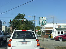
Maine State Route 136 in Freeport

State Route 136 is a numbered state highway in Maine, United States. It begins with Route 125 at the junction of U.S. 1 in Freeport, and travels to Auburn. Although it is only approximately 15 miles (24 km) long, it connects three major Maine commerce areas (Lewiston, Auburn, and Freeport as well as points south.) Many people who do not want to take the Maine Turnpike from Lewiston or Auburn to Portland or other points south of Freeport use Route 136.

References


Wikimedia Foundation. 2010.

Игры ⚽ Поможем решить контрольную работу

Look at other dictionaries:

  • Maine State Route 137 — State Route 137 Route information Maintained by MaineDOT Length: 56.25 mi[1] …   Wikipedia

  • List of Maine State Routes — Standard markers of State Routes in Maine. Highway names Interstates: Interstate x (abbreviated I X) …   Wikipedia

  • New York State Route 37 — NY 37 redirects here. NY 37 may also refer to New York s 37th congressional district. This article is about the current alignment of NY 37. For previous alignments of NY 37, see New York State Route 37 (disambiguation). NYS Route 37 …   Wikipedia

  • New York State Route 26 — NY 26 redirects here. NY 26 may also refer to New York s 26th congressional district. This article is about the current alignment of NY 26. For the former alignment of NY 26 in Central New York, see New York State Route 26 (1924–1930). NYS Route… …   Wikipedia

  • New York State Route 38 — NY 38 redirects here. NY 38 may also refer to New York s 38th congressional district. NYS Route 38 Map of New York with NY 38 highlighted in red …   Wikipedia

  • New York State Route 3 — NY 3 redirects here. NY 3 may also refer to New York s 3rd congressional district. NYS Route 3 Map of the North Country with NY 3 highlighted in red …   Wikipedia

  • New York State Route 376 — This article is about the current alignment of NY 376. For the former alignment of NY 376 in Ulster County, see New York State Route 376 (1930–1933). NYS Route 376 Map of t …   Wikipedia

  • New York State Route 12E — NYS Route 12E Route information Auxiliary route of NY 12 Maintained by NYSDOT, Jefferson County and the city of Watertown …   Wikipedia

  • Maine — This article is about the U.S. state of Maine. For other uses, see Maine (disambiguation). State of Maine …   Wikipedia

  • List of highways numbered 136 — Route 136 redirects here. For the bus route in London, see London Buses route 136. For the other bus route in London, see London Buses route N136. For the bus route in Bucharest, see RATB route 136. For the bus route in Ipswich, see Ipswich Buses …   Wikipedia

Share the article and excerpts

Direct link
Do a right-click on the link above
and select “Copy Link”