- Oregon Route 542
-
Oregon Route 542
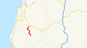
Route information Maintained by ODOT Length: 18.78 mi (30.22 km) Existed: 2003 – present Major junctions South end: Railroad Avenue and Powers South Road in Powers North end:  OR 42 near Myrtle Point
Highway system Oregon highways
Routes • Highways←  OR 540
OR 551  →
→Oregon Route 542 (OR 542) is an Oregon state highway running from OR 42 near Myrtle Point to Powers. OR 542 is known as the Powers Highway No. 242 (see Oregon highways and routes). It is 18.78 miles (30.22 km) long and runs north–south, entirely within Coos County.
OR 542 was established in 2003 as part of Oregon's project to assign route numbers to highways that previously were not assigned, and, as of August 2008, was unsigned.
Contents
Route description
OR 542 begins at an intersection with OR 42 approximately two miles southeast of Myrtle Point and heads south through Broadbent, Warner, and Gaylord to Powers, where it ends at an intersection with Railroad Avenue and Powers South Road.
History
OR 542 was assigned to the Powers Highway in 2003.
Major intersections
Milepost City Intersection 0.00 Near Myrtle Point OR 42 18.91 Powers Railroad Avenue and Powers South Road (End route) References
- Oregon Department of Transportation, Descriptions of US and Oregon Routes, http://www.oregon.gov/ODOT/HWY/TRAFFIC/TEOS_Publications/PDF/Descriptions_of_US_and_Oregon_Routes.pdf, page 32.
- Oregon Department of Transportation, Powers Highway No. 242, ftp://ftp.odot.state.or.us/tdb/trandata/maps/slchart_pdfs_1980_to_2002/Hwy242_2001.pdf
Categories:- State routes in Oregon
- Transportation in Coos County, Oregon


Wikimedia Foundation. 2010.