- Oregon Route 501
-
Oregon Route 501
Route information Maintained by ODOT Length: 9.49 mi (15.27 km) Existed: 2002 – present Major junctions South end: Benton-Lane County line near Alsea North end:  OR 34 in Alsea
Highway system Oregon highways
Routes • Highways←  OR 454
OR 528  →
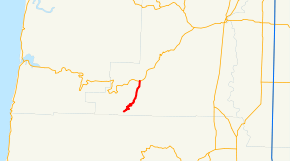
→Oregon Route 501 (OR 501) is an Oregon state highway running from Alsea to the Benton-Lane County line. OR 501 is known as the Alsea-Deadwood Highway No. 201 (see Oregon highways and routes). It is 9.49 miles (15.27 km) long and runs north–south, entirely within Benton County.
OR 501 was established in 2002 as part of Oregon's project to assign route numbers to highways that previously were not assigned.
Contents
Route description
OR 501 begins at an intersection with OR 34 at Alsea and heads south to the Benton-Lane County line, where it ends.
History
The Alsea-Deadwood Highway originally continued south into Lane County to end at OR 36, but has since been truncated to the county line. OR 501 was assigned to the Alsea-Deadwood Highway in 2002.
Major intersections
Milepost City Intersection 0.00 Alsea OR 34 9.49 Near Alsea End route References
- Oregon Department of Transportation, Descriptions of US and Oregon Routes, http://www.oregon.gov/ODOT/HWY/TRAFFIC/TEOS_Publications/PDF/Descriptions_of_US_and_Oregon_Routes.pdf, page 25.
- Oregon Department of Transportation, Alsea-Deadwood Highway No. 501, ftp://ftp.odot.state.or.us/tdb/trandata/maps/slchart_pdfs_1980_to_2002/Hwy201_2001.pdf
- Oregon Highways, Secondary State Highways by County of Origin, http://web.archive.org/web/20050313200205/www.ylekot.com/orehwys/highways_secondary.html
Categories:- State routes in Oregon
- Transportation in Benton County, Oregon


Wikimedia Foundation. 2010.