Oregon Route 453

Oregon Route 453

Oregon Route 453 marker

Oregon Route 453
Route information
Maintained by ODOT
Highway system

Oregon highways
Routes • Highways

OR 452 OR 454

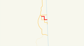
Oregon Route 453 (OR 453) is an Oregon state highway running from OR 454 near Adrian to State Line Road on the Idaho state line near Adrian. OR 453 is known as the Adrian-Arena Valley Highway No. 453 (see Oregon highways and routes). It is 3.19 miles (5.13 km) long and runs northwest to southeast in a stair-step pattern, entirely within Malheur County.

OR 453 was established in 2003 as part of Oregon's project to assign route numbers to highways that previously were not assigned, and, as of July 2010, was unsigned.

Contents

Route description

OR 453 begins at an intersection with OR 454 approximately one mile southeast of Adrian and heads east, south, east, crossing OR 454 again, at the Idaho state line at an intersection with State Line Road.

History

OR 453 was assigned to the Adrian-Arena Valley Highway in 2003.

Major intersections

Milepost City Intersection
0.00 Near Adrian OR 454
2.24 Near Adrian OR 454
3.19 Near Adrian Idaho State Line

References


Wikimedia Foundation. 2010.

Игры ⚽ Поможем сделать НИР

Look at other dictionaries:

  • Oregon Route 454 — Route information Maintained by …   Wikipedia

  • Oregon Route 452 — Route information Maintained by …   Wikipedia

  • Oregon wine — Oregon (wine region) Official name State of Oregon Type U.S. state Year established 1859 Years of wine industry …   Wikipedia

  • Adrian, Oregon — Infobox Settlement official name = Adrian, Oregon settlement type = City nickname = motto = imagesize = image caption = image imagesize = image caption = image mapsize = 250x200px map caption = Location in Oregon mapsize1 = map caption1 =… …   Wikipedia

  • Oregon and Eureka Railroad — Locale Humboldt County, California Dates of operation 1875–1948 Track gauge 4 ft 8 1⁄2 in (1,435 mm) (standard gauge) Headquarters …   Wikipedia

  • Liste der State-, U.S.- und Interstate-Highways in Oregon — Die I 5 in der Nähe des Mount Shasta Die Liste der State, U.S. und Interstate Highways in Oregon ist eine Aufstellung von State Highways in Oregon, USA nach Art und Nummer. Das Straßennetz wird von der Highway Division der Behörde Oregon… …   Deutsch Wikipedia

  • Course of the Rogue River (Oregon) — This article is about the course of the river in Southern Oregon. For the river in Polk County, Oregon, see Rogue River (South Yamhill River). Coordinates: 42°25′21″N 124°25′45″W /  …   Wikipedia

  • Lane County, Oregon — Infobox U.S. County county = Lane County state = Oregon map size = 225 founded = January 29, 1851 seat = Eugene | area total sq mi =4722 area land sq mi =4554 area water sq mi =168 area percentage = 3.55% census yr = 2000 pop = 322959 density km2 …   Wikipedia

  • National Register of Historic Places listings in New Castle County, Delaware — This is a list of the National Register of Historic Places listings in New Castle County, Delaware. Map of all coordinates from Google Map of all coordinates from Bing …   Wikipedia

  • Hillsboro School District — Type and location Type Public Grades K 12 …   Wikipedia

Share the article and excerpts

Direct link
Do a right-click on the link above
and select “Copy Link”