- Shotover River
-
The Shotover River is located in the Otago region of the South Island of New Zealand.[1] The name correctly suggests that this 60 kilometre-long river is fast flowing, with numerous rapids. Despite this, the name comes from Shotover in Oxfordshire, England.[2]
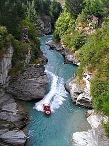
The river flows generally south from the Southern Alps on its journey running through the Skippers Canyon, before draining into the Kawarau River ten kilometres east of Queenstown.
In July 1991 and June 1992 the river froze from bank-to-bank, near Skippers Canyon, and car-tyre sized blocks of ice disrupted tourist activities in July 2007.[3]
The Oxenbridge Tunnel at Arthurs Point is a 170 m (560 ft) tunnel that was part of a failed mining scheme by the Oxenbridge brothers, attempting to divert water from the river to recover gold from the riverbed. It was registered as a Category II Historic Place in 1985,[4] and is used by rafters and kayakers.
Tourist operations
Gold mining featured in its early history and it was one of the richest gold bearing rivers in the world.[citation needed] Gravels washed down from surrounding schist hills naturally concentrate any gold, early prospectors got considerable quantities just by panning.[5] It is now a popular river for tourism.
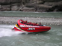
The river is used for commercial white water rafting trips and jet boating rides which operate out of the nearby tourist resort of Queenstown. There are bungy jumping sites on the upper reaches of the river around Skippers Canyon.
References
- ^ "Place Name Detail: Shotover River". New Zealand Geographic Placenames Database. Land Information New Zealand. http://www.linz.govt.nz/placenames/find-names/topographic-names-db/database/index.aspx?p=3695. Retrieved 2009-02-02.
- ^ "Shotover in New Zealand". home.clara.net. 30 September 2009. Archived from the original on 23 April 2011. http://www.webcitation.org/5y8y2X5yd. Retrieved 23 April 2011.
- ^ Wolfe, Felicity (2 February 2009). "Shotover River may freeze, says forecaster". Otago Daily Times. http://www.odt.co.nz/your-town/queenstown/41572/shotover-river-may-freeze-says-forecaster. Retrieved 2009-02-01.
- ^ "Mining Tunnel". Register of Historic Places. New Zealand Historic Places Trust. http://www.historic.org.nz/TheRegister/RegisterSearch/RegisterResults.aspx?RID=5607&m=advanced. Retrieved 2009-04-22.
- ^ Walrond, Carl. "Gold and gold mining - Shotover River". Te Ara Encyclopedia of New Zealand. http://www.teara.govt.nz/EarthSeaAndSky/MineralResources/GoldAndGoldMining/2/ENZ-Resources/Standard/6/en. Retrieved 2009-02-02.
External links
Coordinates: 44°48′29″S 168°44′11″E / 44.807949°S 168.736278°E
Categories:- Rivers used for whitewater recreation
- Rivers of the Otago Region
- Otago Gold Rush
- Otago Region geography stubs
Wikimedia Foundation. 2010.


