- Derinda Township, Jo Daviess County, Illinois
-
"Derinda" redirects here. For other articles with similar names, see Dorinda (disambiguation).
Derinda Township — Township — Location in Jo Daviess County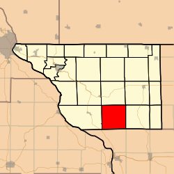 Jo Daviess County's location in Illinois
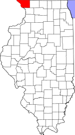
Coordinates: 42°14′22″N 90°09′24″W / 42.23944°N 90.15667°WCoordinates: 42°14′22″N 90°09′24″W / 42.23944°N 90.15667°W Country United States State Illinois County Jo Daviess Established November 2, 1852 Government – Supervisor Area – Total 37.01 sq mi (95.86 km2) – Land 36.95 sq mi (95.7 km2) – Water 0.06 sq mi (0.16 km2) 0.17% Elevation 702 ft (214 m) Population (2000) – Total 318 – Density 8.6/sq mi (3.3/km2) Time zone CST (UTC-6) – Summer (DST) CDT (UTC-5) ZIP codes 61028, 61041, 61074, 61085 GNIS feature ID 0428890 Derinda Township is one of twenty-three townships in Jo Daviess County, Illinois, USA. As of the 2000 census, its population was 318.[1]
Contents
Geography
According to the United States Census Bureau, Derinda Township covers an area of 37.01 square miles (95.9 km2); of this, 36.95 square miles (95.7 km2) (99.83 percent) is land and 0.06 square miles (0.16 km2) (0.17 percent) is water.
Adjacent townships
- Woodbine Township (north)
- Stockton Township (northeast)
- Pleasant Valley Township (east)
- Woodland Township, Carroll County (southeast)
- Washington Township, Carroll County (south)
- Hanover Township (west)
- Elizabeth Township (northwest)
Cemeteries
The township contains these four cemeteries: Albright/Fehler, Massbach/St. John's Evangelical Lutheran, Trinity Lutheran/Derinda Center, and Morrison/Derinda Methodist.
School districts
- River Ridge Community Unit School District 210
- Stockton Community Unit School District 206
- West Carroll Community Unit School District 314
Political districts
- Illinois' 16th congressional district
- State House District 89
- State Senate District 45
References
- "Derinda Township, Jo Daviess County, Illinois". Geographic Names Information System, U.S. Geological Survey. http://geonames.usgs.gov/pls/gnispublic/f?p=gnispq:3:::NO::P3_FID:0428890. Retrieved 2010-01-17.
- United States Census Bureau 2007 TIGER/Line Shapefiles
- United States National Atlas
External links
- Jo Daviess County official site
- City-Data.com
- Illinois State Archives
- Township Officials of Illinois
Municipalities and communities of Jo Daviess County, Illinois Cities 
Villages Apple River | Elizabeth | Hanover | Menominee | Nora | Scales Mound | Stockton | Warren
Townships Apple River | Berreman | Council Hill | Derinda | Dunleith | East Galena | Elizabeth | Guilford | Hanover | Menominee | Nora | Pleasant Valley | Rawlins | Rice | Rush | Scales Mound | Stockton | Thompson | Vinegar Hill | Wards Grove | Warren | West Galena | Woodbine
Unincorporated
communitiesGhost town Categories:- Townships in Jo Daviess County, Illinois


Wikimedia Foundation. 2010.