- Cranstackie
-
Cranstackie 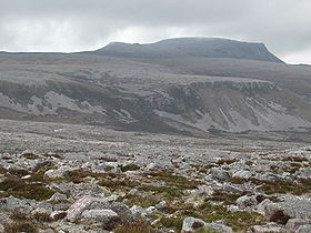
Cranstackie from the east.Elevation 801 m (2,628 ft) Listing Corbett, Marilyn Location Location Assynt, Scotland Topo map OS Landranger 9 OS grid NC350556 Cranstackie is a mountain of 801 m in Sutherland, the northwestern tip of the Scottish Highlands. It is a Corbett located west of Loch Eriboll and northeast of Foinaven. Like Foinaven and Beinn Spionnaidh to the northeast, its top is covered with loose, broken quartzite. The slope is much steeper on the west side than the east, but neither approach is easy due to the covering of loose rock.
Coordinates: 58°27′27″N 4°49′47″W / 58.45738°N 4.82973°W
Categories:- Corbetts
- Mountains and hills of the Northwest Highlands
- Marilyns of Scotland
- Highland geography stubs

Wikimedia Foundation. 2010.