- Texas State Highway 350
Infobox TX State Highway
type=State
route=350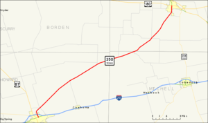
length_mi=47.897
length_ref=TxDOT|SH|350|accessdate=2007-02-01]
length_round=3
formed=by 1943
dir1=South
dir2=North
from=jct|state=TX|BL|20|dab1=Big Spring in Big Spring
junction=jct|state=TX|I|20 in Big Spring
to=jct|state=TX|US|180 in Snyder
previous_type=state
previous_route=349
next_type=state
next_route=351State Highway 350 or SH 350 is a
state highway that runs from Big Spring in westernTexas near Midland northeast to Snyder.Route description
Beginning at a junction with Business Loop I-20 at Big Spring in Howard County, SH 350 intersects Interstate 20 on the northern edge of the town. The highway is known as Owen Street in Big Spring. SH 350 then runs northeast past Howard County municipal airport to its final junction with US 180 at Snyder in Scurry County, where it is known as College Avenue. The route traverses Howard, Mitchell and Scurry counties. Except for the portions in Big Spring and Snyder, most of the terrain covered by the highway is lightly populated
agricultural and oil country. The route has remained essentially unchanged since its original designation in 1943.Junction list
References
External links
* [http://www.dot.state.tx.us/travel/maps.htm Texas official travel map] at the
Texas Department of Transportation (Adobe Acrobat format, magnification required for legibility)
* [http://www.google.com/maps?q=Big+Spring,+TX&ie=UTF8&z=17&ll=32.267267,-101.474791&spn=0.005343,0.010836&t=k&om=1 Satellite image of junction of SH 350 with Interstate 20 in Big Spring] atGoogle Maps

Wikimedia Foundation. 2010.