- DEPTHX
-
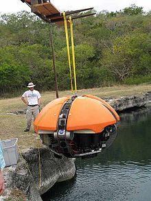 DEPTHX robot being lowered into La Pilita, one of several water-filled sinkholes in Sistema Zacaton (in northeastern Mexico). Photo by Marc Airhart, Jackson School of Geosciences, March 2007.
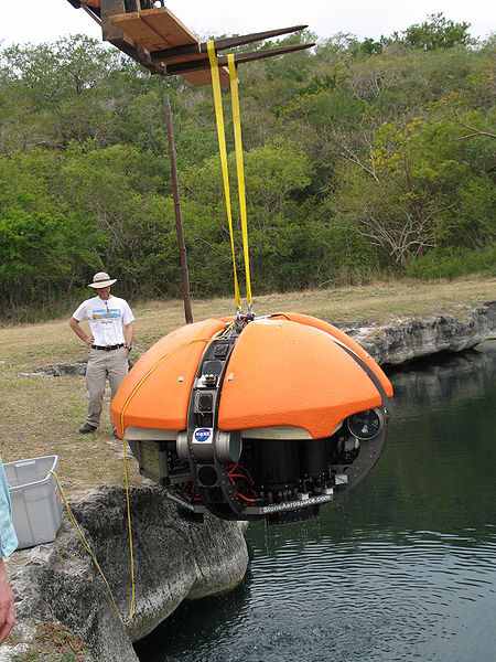
The Deep Phreatic Thermal Explorer (DEPTHX) is an autonomous underwater vehicle, designed to explore deep underwater caves. It is purported to be the most advanced robotic vehicle of its kind on Earth. Its primary function is observation, with an array of sonar sensors (for 3D mapping) all around its flattened spheroid hull. It is about {convert|7|ft|m}} in diameter, and designed to make its own decisions, rather than solely following instructions directly given from human observers.
DEPTHX was built in 2006 and used to conduct field experiments in Mexico from January to May 2007. It demonstrated several technologies for navigation, decision making and biological detection that might be used someday to explore Jupiter's moon Europa.
DEPTHX was the first robot to demonstrate three-dimensional SLAM technology, enabling it to map unexplored spaces by creating a 3D map on the fly as it travels and to know where it is within that map at all times. It successfully collected microbiological samples, which led to the discovery by scientists at the Colorado School of Mines of several new classes of microbes. Finally, DEPTHX successfully mapped the lower portion and bottom of the world's deepest water-filled sinkhole, Cenote Zacatón. Because of its great depth (over 1,000 feet [300 m]), human divers had failed to reach (or even detect with sonar instruments) the bottom.
History
One of the driving forces behind the intensely collaborative DEPTHX mission—in many ways its instigator—was Marcus Gary, a doctoral candidate in hydrogeology at the Jackson School of Geosciences. For many years, Gary has studied Sistema Zacatón--a system of water-filled sinkholes in northeastern Mexico including the deepest, Cenote Zacatón. He's tried to understand how the sinkholes formed and how they evolve over time.
At a barbecue in Austin, Texas in about 2002, Gary asked Bill Stone, a world famous cave diver and engineer, if it would be possible to build a robot to explore the Mexican cave system. The data a robot could collect about the internal structures of the sinkholes and environmental parameters in the water, Gary reasoned, would help hydrogeologists understand how the sinkholes form and evolve over time.
For Stone, the project sounded like a great way to develop robotic technologies that might one day be useful in the search for life in space. NASA thought so too and funded the three-year, $5 million DEPTHX mission. For NASA, the long-term target is Jupiter’s ice-covered moon Europa, which appears to harbor a vast salt water ocean with the potential to support life. As a stepping stone toward such a mission, NASA is funding the ENDURANCE expeditions to Antarctica’s Lake Bonney in late 2008 and late 2009 using the technology from the DEPTHX robot.
DEPTHX was built during 2006 at Stone Aerospace in Austin, Texas. Preliminary dives took place at the Applied Research Laboratory at The University of Texas at Austin, and under outdoor conditions at the Quarries, a swimming hole owned by Austin’s Hyde Park Baptist Church.[1]
One of the distinctive qualities of the 3,300 pounds (1,500 kg), computerized, underwater vehicle is that it makes its own decisions. With more than 100 sensors, 36 onboard computers, and 16 thrusters and actuators, DEPTHX decides where to swim, which samples to collect, and how to get home, based on maps that the probe draws during each dive.
By January 2007, team members from The University of Texas at Austin, Carnegie Mellon University, Southwest Research Institute, Colorado School of Mines, and Stone Aerospace were ready to head to Mexico to continue testing DEPTHX, the world’s only semi-autonomous cave diving robot.
Fieldwork Timeline:
- January 25-27, 2007 - The DEPTHX Team begins surveying the world's deepest water-filled sinkhole, Zacatón in Mexico.[2][3]
- February 4-10, 2007 - Field operations at la Pilita, one of the sinkholes in Sistema Zacatón. DEPTHX runs long autonomous missions to map the area and collect scientific data.[2][4]
- May 2007 - DEPTHX is lowered into Zacatón for the first time and maps the bottom for the first time. Three-dimensional SLAM technology is demonstrated, microbiological samples are collected, and autonomous operation demonstrated.[9][10][11]
Field experiments for the DEPTHX robot ended in May 2007. Some components of DEPTHX have been reused on the follow-on ENDURANCE project. ENDURANCE successfully completed its mission in frozen-over Lake Bonney in the Dry Valleys of Antarctica in the austral summer of 2008 but returned again in 2009.[12]
References
- ^ Vlahos, James (2007-02-01). "Robot Subs in Space". Popular Science. http://www.popsci.com/military-aviation-space/article/2007-02/robot-subs-space?page=1. Retrieved 2011-02-16. "PopSci innovator Bill Stone plans to drop one of the world´s most advanced underwater robots into the deepest hole on Earth. If all goes well, this thing just might help get him to the moon"
- ^ a b DEPTHX: Zacaton - Mission 1 (Stone Aerospace, Jan/Feb 2007)
- ^ DEPTHX Field Notes (Carnegie Mellon University, January 2007)
- ^ DEPTHX Field Notes (Carnegie Mellon University, February 2007)
- ^ Dispatches from Zacatón (Marc Airhart, March 2007)
- ^ DEPTHX Mission 2 (Marcus Gary, March 2007)
- ^ DEPTHX: Zacaton - Mission 2 (Stone Aerospace, March 2007)
- ^ DEPTHX Field Notes (Carnegie Mellon University, March 2007)
- ^ DEPTHX: Zacaton - Mission 3 (Stone Aerospace, May 2007)
- ^ Dispatches from Zacatón (Marc Airhart, May 2007)
- ^ DEPTHX Field Notes (Carnegie Mellon University, May 2007)
- ^ Exploring Bonney Peter Rejcek, Antarctic Sun, May 2009.
External links
- ENDURANCE
- Dispatches from Zacatón Live field updates by Marc Airhart, Jackson School of Geosciences, March & May 2007
- NASA-funded Robotic Sub Makes Final Dive To Reach Bottom of Earth's Deepest Sinkhole Jackson School of Geosciences press release, May 14, 2007
- Stone Aerospace DEPTHX designer and systems integrator
- DEPTHX at Robotics Center at Carnegie Mellon University Responsible for software that controls navigation, mapping and autonomous decision making
- Deep Mission: Aquatic Robotic Diver Could Aid Europa Exploration
- Mexican Sinkhole May Lead NASA to Jupiter Washington Post, May 14, 2007
- Robotic submarine reaches new depths New Scientist, May 18, 2007
- Swimming to Europa IEEE Spectrum, September 1, 2007
Categories:- Caving techniques
- Robotic submarines
- Underwater diving
Wikimedia Foundation. 2010.