- Oregon Route 173
-
Oregon Route 173
Route information Maintained by ODOT Length: 5.37 mi (8.64 km) Existed: 2002 – present Major junctions South end:  US 26 near Government Camp
North end: Timberline Lodge Highway system Oregon highways
Routes • Highways←  OR 164
OR 180  →
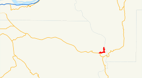
→Oregon Route 173 is an Oregon state highway running from Timberline Lodge in Clackamas County to U.S. Route 26 near Government Camp. OR 173 is known as the Timberline Highway No. 173 (see Oregon highways and routes). It is 5.37 miles (8.64 km) long and runs in a northeast to southwest "L" pattern, entirely within Clackamas County.[1],[2]
OR 173 was established in 2002 as part of Oregon's project to assign route numbers to highways that previously were not assigned, and, as of September 2010, was unsigned.
Contents
Route description
OR 173 begins at Timberline Lodge. It heads south and then west down Mount Hood to an intersection with US 26 approximately one mile east of Government Camp, where it ends.[3]
History
OR 173 was assigned to the Timberline Highway in 2002.[4]
Major intersections
Milepost City Intersection 0.12 Timberline Lodge Beginning of Route 5.49 Near Government Camp U.S. Route 26 Related routes
- U.S. Route 26
References
- Oregon Department of Transportation, Descriptions of US and Oregon Routes, http://www.oregon.gov/ODOT/HWY/TRAFFIC/TEOS_Publications/PDF/Descriptions_of_US_and_Oregon_Routes.pdf, page 27.
- Oregon Department of Transportation, Timberline Highway No. 173, ftp://ftp.odot.state.or.us/tdb/trandata/maps/slchart_pdfs_1980_to_2002/Hwy173_1997.pdf
Categories:- State routes in Oregon
- Transportation in Clackamas County, Oregon
- Mount Hood National Forest


Wikimedia Foundation. 2010.