- Waimakariri River
Infobox_River
river_name = Waimakariri River
image_size = 300px
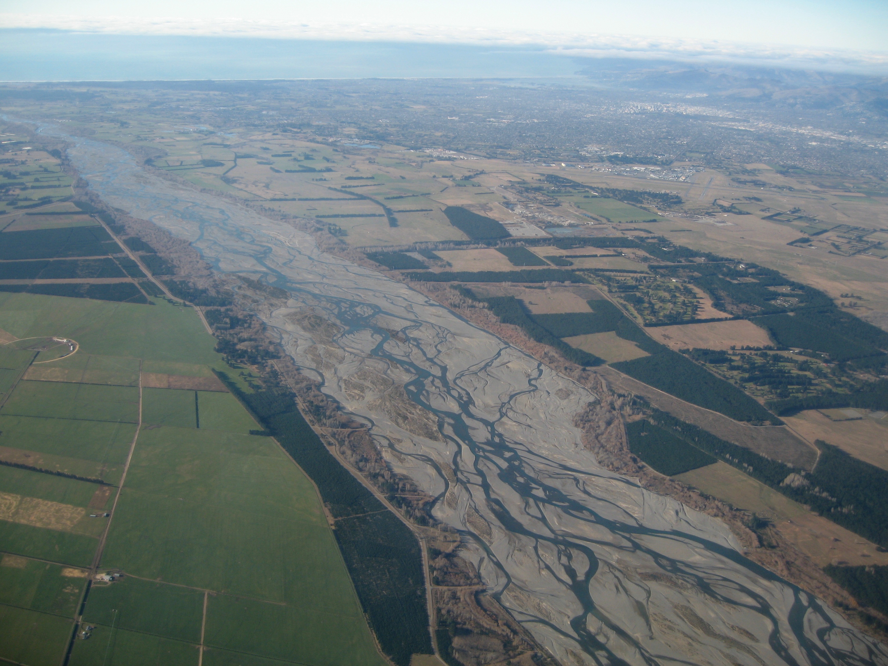
caption = The Waimakariri with Christchurch in the background.
origin =Southern Alps
mouth =
basin_countries =New Zealand
length =
elevation =
mouth_elevation = 0 metres
discharge =
watershed =The Waimakariri River is the largest of the North Canterbury Rivers, in the
South Island ofNew Zealand . It flows for 151 kilometres in a generally southeastward direction from theSouthern Alps across theCanterbury Plains to thePacific Ocean .cite book
last = Logan
first = Robert
authorlink = Robert Logan
title = Waimakariri. The story of Canterbury's "river of cold rushing water"
publisher = Robert Logan
location = Christchurch
year = 1987
isbn = 0473005204]The river rises on the eastern flanks of the Southern Alps, eight kilometres southwest of
Arthur's Pass . For much of its upper reaches, the river is braided, with wide shingle beds. As the river approaches theCanterbury Plains , it passes through a belt of mountains, and is forced into a narrow canyon (theWaimakariri Gorge ), before reverting to its braided form for its passage across the plains. It finally enters the Pacific north of Christchurch, near the town ofKaiapoi .Chinook salmon ("Oncorhynchus tshawytscha") were introduced from California in the 1900s and persist today. [McDowall, R. M. (1990) New Zealand freshwater fishes: a natural history and guide. Heinemann-Reed, Auckland, 553 p.]In Māori, "Waimakariri" has several meanings, one of which is "river of cold rushing water".cite book
last = Logan
first = Robert
authorlink = Robert Logan
title = Waimakariri. The story of Canterbury's "river of cold rushing water"
publisher = Robert Logan
location = Christchurch
year = 1987
isbn = 0473005204]In the 1850s European settlers gave the river the name "Courtenay River", but it lapsed into disuse. [ [http://www.teara.govt.nz/Places/Canterbury/Canterbury/6/en Canterbury, discovery and settlement] , Te Ara Encyclopedia of New Zealand website, retrieved 18 April 2008.]
Geological evidence indicates that the river mouth has been very mobile, at times flowing through the current location of Christchurch and even flowing into
Lake Ellesmere south ofBanks Peninsula for a time. [ [http://www.ecan.govt.nz/Our+Environment/Land/Parks+and+Reserves/Waimakariri+River.htm Waimakariri River, An important asset to the region] , Environment Canterbury website, retrieved 18 April 2008.]Instead of being unoccupied crown land as are most New Zealand river beds, the bed of the Waimakariri River is vested in the
Canterbury Regional Council (Environment Canterbury) . [Waimakariri River Improvement Act 1922, [http://www.legislation.govt.nz/act/local/1922/0022/latest/DLM42599.html Section 17(1)] - Parliament of New Zealand.]The river is known colloquially in Canterbury as "The Waimak".
Development
In 1923 the river was investigated for a hydroelectric dam to supply electricity to Christchurch. It received support from the community but the dam was never built since the Government offered inexpensive electricity from the
Lake Coleridge scheme. [cite news
last = Crean
first = Mike
coauthors =
title = Waimak's elusive dam
work =
pages =
publisher =The Press
date = 2008-04-26
url =
accessdate = 2008-06-23 ]The
Central Plains Water Trust is proposing to take 40 cumecs of water from two points on the Waimakariri River as part of theCentral Plains Water enhancement scheme. [ [http://www.ecan.govt.nz/Resource+Consents/Central+Plains+Water+Trust.htm Central Plains Water Trust applications for resource consent] Environment Canterbury Resource Consents webpage, retrieved 6 October 2007.]References
Wikimedia Foundation. 2010.