- Lika-Krbava
Infobox Former Subdivision
native_name = Lika-Krbava
conventional_long_name = Lika-Korbava County
common_name = Lika-Korbava
subdivision = County
nation = Croatia-Slavonia
p1 =
s1 =
year_start = 12th century
event_end = Treaty of Trianon
year_end = 1920
date_end = June 4
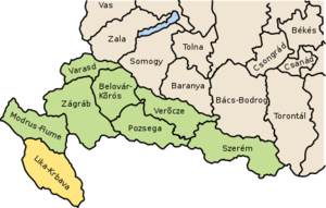
image_map_caption = Map of the county within Croatia-Slavonia,Kingdom of Hungary
capital = Gospić
stat_area1 = 6211
stat_pop1 = 204710
stat_year1 = 1910
today =Croatia Lika-Krbava (in Croatian) or Lika-Korbava (in Hungarian) was the name of a historic administrative county (comitatus) of the autonomous region
Croatia-Slavonia within theKingdom of Hungary . Its territory is presently in south-westernCroatia .Lika andKrbava are the names of two valleys in the county (Gospić lies inLika ). The capital of the county was Gospić.Geography
Lika-Krbava county shared borders with the
Austria n landsDalmatia andBosnia-Herzegovina and the Hungarian countyModrus-Fiume (also in Croatia-Slavonia). The county has a strip ofAdriatic Sea coast. Its area was 6211 km² around 1910.History
The territory of Lika-Krbava county, like the rest of
Croatia , became part of theKingdom of Hungary in the 12th century, and in 1526 part of theHabsburg Monarchy . In 1918 (confirmed by theTreaty of Trianon 1920), the county became part of the newly formedKingdom of Serbs, Croats and Slovenes (Yugoslavia). Since 1991, whenCroatia became independent fromYugoslavia , the county is part ofCroatia .Demographics
In 1910, the population of the county was 204,710.
Population by language (1910 census):
*Serbian = 104,036
*Croatian = 100,346
*otherubdivisions
In the early 20th century, the subdivisions of Lika-Krbava county were:

Wikimedia Foundation. 2010.