- Daggons Road railway station
-
Daggons Road 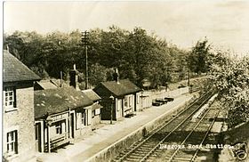
Location Place Alderholt Area East Dorset, Dorset Grid reference SU113126 Operations Original company Salisbury and Dorset Junction Railway Pre-grouping London and South Western Railway Post-grouping Southern Railway
Southern Region of British RailwaysPlatforms 1 History 1 January 1876 Opened 4 May 1964 Closed Disused railway stations in the United Kingdom Closed railway stations in Britain
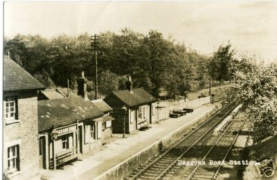
A B C D–F G H–J K–L M–O P–R S T–V W–ZDaggons Road was a railway station serving the village of Alderholt, in Dorset, to the south west of Fordingbridge, in Hampshire. It was one of many casualties of the mass closure of British railway lines in the 1960s and 1970s; the last service was on 4 May 1964. It was on the Salisbury and Dorset Junction Railway, which ran North-South along the River Avon just to the West of the New Forest, connecting Salisbury to the North and Poole to the south.
Today, the road through the centre of Alderholt village is still called Station Road, changing to Daggons Road at the point where the line crossed the road. A residential cul-de-sac named Station Yard (previously Daggons Road) occupies the land where the station once stood on the north side of Daggons Road, and there is another named Churchill Close opposite to the south.
Preceding station Disused railways Following station Fordingbridge British Rail
Southern Region
Salisbury and Dorset Junction RailwayVerwood External links
Categories:- Disused railway stations in Dorset
- Former London and South Western Railway stations
- Railway stations opened in 1876
- Railway stations closed in 1964
- Beeching closures in England
- South West England railway station stubs
Wikimedia Foundation. 2010.