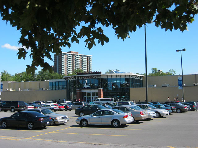
- Billings Bridge Plaza
infobox shopping mall
shopping_mall_name = Billings Bridge Plaza
caption =
location =Ottawa ,Ontario ,Canada
opening_date = 1954
developer=
owner = Capital City Shopping Centre Ltd.
manager= [http://www.20vic.com 20 VIC Management Inc.]
number_of_stores = 85
number_of_anchors = 2
parking = 1519 spaces
floor_area = 460,000 square feet
floors = 2
website=http://www.billingsbridgeplaza.com|http://www.billingsbridgeplaza.comThe Billings Bridge Plaza is a shopping centre located in
Ottawa ,Canada . Originally built in 1954, it was the first shopping centre built in the city. It did not become enclosed until 1975. It is located immediately south of theRideau River on the corner of Bank Street and Riverside Drive, beside a large athletics complex, theRA Centre . The anchor stores areZellers andYour Independent Grocer . It is a medium-sized mall by modern standards with 85 stores [cite web
url=http://www.billingsbridgeplaza.com/directory.htm
title=Billings Bridge Plaza: Store directory
accessdate=2007-10-16] .When it was built it had only six stores, of which only
Reitmans remains to this day. In 1962 the mall underwent a major expansion to 23 stores which made it the largest shopping centre in Ottawa at the time.Ogilvy's opened a location at Billings Bridge in the 1962. Later it was replaced by Robinson's, which was itself replaced byZellers in 1996. The second major expansion came in 1975, which saw the addition of an office tower housing federal government offices, and the mall became enclosed, following the trend in shopping centres at the time. In February 2008, theLoblaws store (which had been one of the original stores) was rebranded asYour Independent Grocer (another ofLoblaw Companies ' brands).The shopping centre was extensively refurbished in 1999. A large new atrium and food court were added. In July 2006 another major renovation programme was started, expanding by 25,000 sq.ft. Construction was completed in 2007. It consisted of adding many new stores and a renovation of the food court, removing the bridge and replacing it with
Ben and Jerry's and Printwell. This construction changed the whole atmoshpere on the first floor. There is a lot of light compared to before.6.2 million people visit Billings Bridge annually. At 450,000 square feet (42,000 m²), it earns C$543 (2003) per square foot (C$5800/m²), up from C$332 per square foot (C$3600/m²) in 1998.
Capital City Shopping Centre Ltd. has owned the plaza since 1962, when they bought it from the original developersFact|date=October 2007. It is the 9th largest mall in Ottawa in terms of retail area, and the 6th largest in terms of number of storesFact|date=October 2007.The shopping centre is located on the Transitway, and serves as a major hub for
OC Transpo bus services. The station is called Billings Bridge.Billings Bridge is named after
Braddish Billings , an original settler of Ottawa. The bridge carrying Bank Street over the river, near the site of the current mall, came to be known as Billings' Bridge as it led to his property.Anchors
*
Your Independent Grocer (29,636 sq. ft.)
*Zellers (98,950 sq. ft.)ee also
*Billings Bridge Transitway Station
References
External links
* [http://www.billingsbridgeplaza.com/ Official website]
Wikimedia Foundation. 2010.