- Jalalabad Airport
-
Jalalabad Airport 
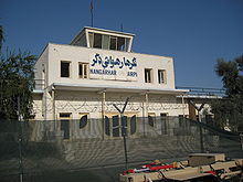
Control tower of the Jalalabad Airport in Nangarhar IATA: JAA – ICAO: OAJL Summary Location Jalalabad Elevation AMSL 1,814 ft / 553 m Coordinates 34°23′57″N 70°29′58″E / 34.39917°N 70.49944°ECoordinates: 34°23′57″N 70°29′58″E / 34.39917°N 70.49944°E Runways Direction Length Surface ft m 13/31 7,276 2,218 Asphalt Jalalabad Airport (IATA: JAA, ICAO: OAJL) is located 3 miles (5 km) southeast of Jalalabad city in Afghanistan. This airport is currently being used only for military purposes and sometimes the United Nations' aircraft use this airport.
Contents
New Jalalabad Airport
The construction of a new civilian airport is underway in Gambiri area to north west of Jalalabad.The new airport will be constructed with financial assistance of the US and will be opened in 2011, Hamidullah Qaderi, Minister of Transport and Civil Aviation of Afghanistan, said on April 26, 2009.
2010 attack
On 30 June 2010 a car bomb was set off and militants stormed the airport. According to Zabiullah Mujahid, an Taliban spokesman, the Taliban were responsible and killed 32 Afghan and non-Afghan security forces. According to NATO there were eight Taliban deaths and one Afghan and one coalition member injured.[1][2]
Airlines and destinations
Currently, there are no scheduled airlines operating at Jalalabad Airport.
Cargo
Airlines Destinations Khyber Afghan Airlines References
External links
Categories:- Airports in Afghanistan
- Buildings and structures in Nangarhar Province
- Asian airport stubs
- Afghan building and structure stubs
Wikimedia Foundation. 2010.
