Marsden Moor Estate

Marsden Moor Estate

Coordinates: 53°36′04″N 1°57′36″W / 53.601°N 1.960°W / 53.601; -1.960

Marsden Moor Estate

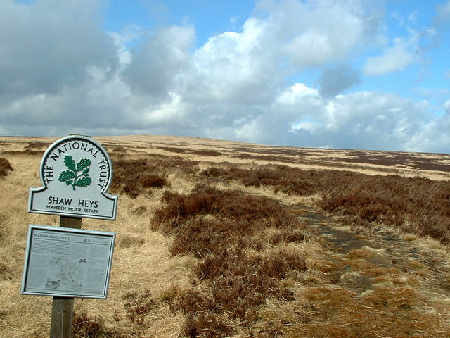
The Marsden Moor Estate is a large expanse of moorland situated in the Pennines, between the conurbations of West Yorkshire and Greater Manchester in the north of England. It is named after the adjacent small town of Marsden, and is owned and administered by the National Trust to whom it was conveyed in 1955 by the Radcliffe family in lieu of death duties.

The estate covers some 2,429 ha (5,685 acres) of unenclosed common moorland and almost surrounds Marsden. It forms the most northerly section of the Peak District National Park. The landscape is made up of valleys, peaks and crags and has long been modified by man. The fact that Marsden forms the eastern gateway to the important Standedge crossing of the moors has resulted in the presence of transport related archaeological remains dating from pre-Roman times to the great engineering structures of the canal and railway ages. The moors have also been used as a water catchment area since the Victorian era, and several reservoirs are present, along with their associated catchwaters.[1]

The landscape supports large numbers of moorland birds such as the Golden Plover, Red Grouse, Curlew and Twite. The estate is a designated Site of Special Scientific Interest, forms part of an Special Protection Area and is a candidate Special Area of Conservation.[1]

The estate is managed from a base in the old goods yard, adjacent to Marsden railway station, and the old goods shed has been converted into a public exhibition, entitled Welcome to Marsden, which gives an overview of the estate and its history.[1]

References

  1. ^ a b c "Marsden Moor - What to see and do". National Trust. Archived from the original on July 22, 2006. http://web.archive.org/web/20060722005723/http://www.nationaltrust.org.uk/main/w-vh/w-visits/w-findaplace/w-marsdenmoorestate/w-marsdenmoor-seeanddo.htm. Retrieved December 24, 2006. 

External links


Wikimedia Foundation. 2010.

Игры ⚽ Нужно решить контрольную?

Look at other dictionaries:

  • Marsden railway station — Marsden Location Place …   Wikipedia

  • Marsden, West Yorkshire — Coordinates: 53°36′04″N 1°55′36″W / 53.6011°N 1.9267°W / 53.6011; 1.9267 …   Wikipedia

  • Standedge Tunnels — Location map|United Kingdom label = background = white lat = 53.591283 long = 1.95996 caption = Map showing the location of the Standedge Tunnels in the United Kingdom float = right width = 185The Standedge Tunnels (Standedge is normally… …   Wikipedia

  • Colne Valley — For the constituency of this name, see Colne Valley (UK Parliament constituency). The Colne Valley is a steep sided valley on the east flank of the Pennine Hills in the English county of West Yorkshire. It takes its name from the River Colne… …   Wikipedia

  • Standedge — Location map|United Kingdom label = background = white lat = 53.583196 long = 1.969031 caption = Map showing the location of Standedge in the United Kingdom float = right width = 185Standedge (normally pronounced Stannige ) is a moorland… …   Wikipedia

  • List of National Trust properties in England — This is a list of National Trust Properties in England, including any stately home, historic house, castle, abbey, museum or other property in the care of the National Trust in England. Contents 1 Bedfordshire …   Wikipedia

  • List of RAF stations — This List of RAF stations is a comprehensive list of all stations, airbases, airfields and administrative headquarters of the Royal Air Force past and present.:Note Current RAF Stations will be listed under the currently recognised county of the… …   Wikipedia

  • List of bus routes in Derbyshire — A map of the area these services operate in. This is a list of bus routes in Derbyshire. The major bus operators in the Derbyshire area are Arriva Midlands and Trent Barton. Other operators in Derbyshire are Bowers, Hulleys of Baslow, Notts Derby …   Wikipedia

  • Huddersfield — For the constituency of the same name, see Huddersfield (UK Parliament constituency). Coordinates: 53°38′42″N 1°46′47″W / 53.6450°N 1.7798°W / …   Wikipedia

  • 2000 New Year Honours — The insignia of the Grand Cross of the Order of St Michael and St George: Andrew Wood was awarded the Grand Cross in this Honours list. The New Year Honours 2000 for the United Kingdom were announced on 31 December 1999, to celebrate the year… …   Wikipedia

Share the article and excerpts

Direct link
Do a right-click on the link above
and select “Copy Link”