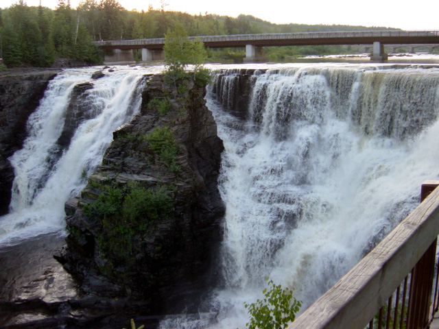
- Kakabeka Falls
Infobox Waterfall
name = Kakabeka Falls

image_size = 288
caption = Kakabeka Falls
location = Oliver Paipoonge,Ontario ,Canada
coordinates = coord|48.4029|-89.6256|display=inline,title
watercourse =Kaministiquia River
type = Plunge [cite web |url=http://www.start.ca/users/mharris/waterfalls/kakabeka-falls.html |title=Waterfalls of Ontario - Kakabeka Falls |accessdate=2007-09-21]
height = m to ft|40|abbr=yes|precision=0
number_drops = Two
average_flow = 50 m³/s (1766 cu ft/s) [Ontario Power Generation, " [http://www.opg.com/safety/water/river/kaministiquia/kakabekaFalls.pdf Kakabeka Falls Total Outflow] ". Retrieved on22 September 2007 .]Kakabeka Falls (IPAEng|ˈkɛkəˈbɛkə) is a
waterfall on theKaministiquia River , located beside the village of Kakabeka Falls in the municipality of Oliver Paipoonge,Ontario , km to mi|30|abbr=yes|precision=0 west of the city of Thunder Bay. The falls has a drop of m to ft|40|abbr=yes|precision=0, [cite web |url=http://www.ontarioparks.com/english/kaka.html |title=Ontario Parks - Kakabeka Falls |accessdate=2007-09-21] cascading into a gorge carved out of thePrecambrian Shield bymeltwater following thelast glacial maximum .cite web |url=http://www.borealforest.org/greenspaces/tbay.htm#kakabeka |title=Thunder Bay Green Spaces - Kakabeka Falls Provincial Park |accessdate=2007-09-21] It is the second highest waterfall in Ontario afterNiagara Falls , and has been consequently nicknamed "the Niagara of the North".The rock face of the falls and the
escarpment s along the gorge are composed primarily of unstable shale, and are eroding. These rocks host sensitiveflora , and contain some of the oldestfossils in existence, some 1.6 billion years of age.See above paragraph] Due to the fragile rock, going into the gorge below the falls is prohibited. [cite web |url=http://www.gowaterfalling.com/waterfalls/kakabeka.shtml |title=Go Waterfalling - Kakabeka Falls |accessdate=2007-09-21]The name "Kakabeka" comes from the Ojibwe word "gakaabikaa" "waterfall over a cliff" (pronounced|ˈɡəkaːˈbɪkaː
[ help] ). [cite web |url=http://www.freelang.net/dictionary/ojibwe.html |title=Freelang Ojibwe Dictionary |accessdate=2007-03-11]Kakabeka Falls Provincial Park
Infobox Protected area
name = Kakabeka Falls Provincial Park
iucn_category = II

base_width = 288
location = Kakabeka Falls,Ontario
lat_degrees=48 |lat_minutes=24 |lat_seconds=10.44 |lat_direction=N
long_degrees=89 |long_minutes=37 |long_seconds=32.16 |long_direction=W
area = 5 km² (1,236 acres)
established = 1955
governing_body =Ontario Parks Kakabeka Falls Provincial Park, established in 1955, [cite book | last = Killan | first = Gerald | title = Protected Places: A History of Ontario's Provincial Parks System | publisher = Dundurn Press Ltd. | date = 1993 | pages = pp. 35 | url = http://books.google.ca/books?id=AmEwoPNZtkwC&pg=PA35&dq=kakabeka+falls&sig=yGD2M40cep5ms_TalZtTofSahNo | isbn = 155002180X] covers 5 km² (1,236 acres) and is managed by
Ontario Parks . It surrounds the falls and extends along the Kaministiquia River, which was used centuries ago by Voyageurs, who were the first Europeans to overwinter annually innorthern Ontario . They used the Kaministiquia River as a major route to the northwest, with a km to mi|1.3|abbr=yes|precision=0 mountainportage around the falls. [cite web |url=http://www.rvtravelog.com/canada.dir/kfalls.dir/kfalls1.htm |title=rvtravelog.com - Kakabeka Falls |accessdate=2007-09-21] A hotel with terrace which was once located on the edge of the gorge was removed after the Park's creation. It included a round restaurant that once overlooked the falls, and in winter would get covered in a thick layer of ice from the spray of the falls.The park has two campgrounds with 169 camp sites, 90 of which have electricity. The park maintains km to mi|17.9|abbr=yes|precision=0 of hiking on six trails, [cite web |url=http://www.ontarioparks.com/english/kaka-hiking.html |title=Ontario Parks - Kakabeka Falls - Hiking |accessdate=2007-09-21] and offers
cross-country ski trails in the winter. A smallNatural Heritage Education program is operated within the park in the summer, and offers daily interpretive programs, guided hikes, and a visitor centre.The Legend of Green Mantle
The Legend of Green Mantle is about an
Ojibwe chief who upon hearing news of an imminent attack from theSioux tribe instructs his daughter, Princess Green Mantle, to devise a plan to protect her people. She entered the Sioux camp along the Kaministiquia River and, pretending to be lost, she bargained with them to spare her life if she would bring them to her father's camp. Placed at the head of thecanoe , she instead led herself and the Sioux warriors over the falls to their deaths, sparing her tribe from the attack. The legend claims that one can see Green Mantle when looking into the mist of Kakabeka Falls, a monument to the princess that gave her life to save her people. [cite web |url=http://www.firstpeople.us/FP-Html-Legends/PrincessOfTheMist-Ojibwa.html |title=Firstpeople.us - Princess of the Mist: The legend of Princess Green Mantle |accessdate=2007-09-21] Other versions of the legend say she came across the Sioux herself, and later jumped out of the canoe ahead of the falls and swam to shore, leaving the Sioux to go over the falls, then ran back to the camp to warn her people. [cite book | last = Campbell | first = Marjorie Elliott(Wilkins) Campbell | title = Ontario | publisher = Ryerson Press | date = 1953 | pages = pp. 178 | url = http://books.google.com/books?id=oNwdAAAAMAAJ&q=kakabeka+falls&dq=kakabeka+falls&pgis=1 ]The falls in art
The most famous painting featuring the falls, painted by
Lucius Richard O'Brien in 1882, is held by theNational Gallery of Canada . [cite web |url=http://cybermuse.gallery.ca/cybermuse/search/artwork_e.jsp?mkey=9526 |title=National Gallery of Canada - Lucius R. O'Brien - Kakabeka Falls, Kamanistiquia River (1882) |accessdate=2007-09-21]Frances Anne Hopkins , whose historic paintings are well-known for her portrayal of Canadian life, painted the falls in 1877. Her painting, "The Red River Expedition at Kakabeka Falls, Ontario", depicts the Red River Expedition, an expedition which set out fromToronto in an attempt to interdictLouis Riel , portaging at the falls. [cite web |url=http://www.collectionscanada.ca/05/0529/052910/05291040_e.html |title=Collections Canada - Frances Anne Hopkins - The Red River Expedition at Kakabeka Falls, Ontario (1877)|accessdate=2007-09-21]See also
*
Kakabeka Falls Generating Station
*Kaministiquia River References
External links
* [http://www.ontarioparks.com/english/kaka.html Kakabeka Falls Provincial Park]
* [http://www.firstpeople.us/FP-Html-Legends/PrincessOfTheMist-Ojibwa.html Firstpeople.us - Princess of the Mist: The legend of Princess Green Mantle]
* [http://cybermuse.gallery.ca/cybermuse/search/artwork_e.jsp?mkey=9526 National Gallery of Canada - Lucius R. O'Brien - Kakabeka Falls, Kamanistiquia River (1882)]
* [http://www.collectionscanada.ca/05/0529/052910/05291040_e.html Collections Canada - Frances Anne Hopkins - The Red River Expedition at Kakabeka Falls, Ontario (1877)]
Wikimedia Foundation. 2010.
