- Meckesheim
-
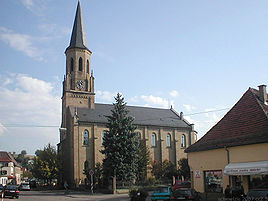
Meckesheim Protestant Church 
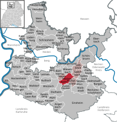
Coordinates 49°19′17″N 8°48′55″E / 49.32139°N 8.81528°ECoordinates: 49°19′17″N 8°48′55″E / 49.32139°N 8.81528°E Administration Country Germany State Baden-Württemberg Admin. region Karlsruhe District Rhein-Neckar-Kreis Mayor Hans-Jürgen Moos Basic statistics Area 16.33 km2 (6.31 sq mi) Elevation 154 m (505 ft) Population 5,278 (31 December 2010)[1] - Density 323 /km2 (837 /sq mi) Other information Time zone CET/CEST (UTC+1/+2) Licence plate HD Postal code 74909 Area code 06226 Website www.meckesheim.de Meckesheim is a village in south western Germany. It is located between Heidelberg and Sinsheim in the Rhein-Neckar district in the state of Baden-Württemberg.
History
In 772 and 822 Meckesheim was mentioned for the first times as Heim des Mechino (home of Mechino) or Mechinos Heim (Mechino's home) in the Codex of Lorsch. The Martin's Chappel which ruins are east of the village is one of the oldest churches in the region. Since 1330 Meckesheim and the villages around was a part of the Kurpfalz. After the end of this territory in 1803 the village became a part of Baden.
Traffic (rail)
Meckesheim is connected via the Badenian Odenwald line from Heidelberg (1862, northwestern of Meckesheim) to Mosbach(Baden) (eastwards, 1862) and Würzburg (completed 1866). In 1868, a branch to Bad Rappenau (southeast of Meckesheim, important for salt production in Baden) was added and in 1869 completed to Bad Friedrichshall-Jagstfeld, in this way there were now a direct connection to Stuttgart via Heilbronn, too. In 1902, a normal gauge minor railway westwards to station Wiesloch-Walldorf on Baden Mainline was opened, but the Meckesheim--Schatthausen section already 1922 closed. During WWII the line eastbound became a trunk due to retreating German troops, and in 1971 the line was shortened till Aglasterhausen.
Since 2009 and 2010, these two lines (Elsenztalbahn and Badische Schwarzbachtalbahn) are incorporated into the rapid suburban system Rhein-Neckar-S-Bahn. Due to the branching Schwarzbach valley line and an amount of passengers in the village, Meckesheim is also a halt (since 1997) in the RE-train system between Mannheim, Heidelberg, and Heilbronn. In this way you can reach Heidelberg Central station (distance 23km = 13.75 miles) within 17 minutes.
As DB Netz (the organization owning the railway tracks) refused during planning the S-Bahn to incorporate capacities for goods trains and (even, if already existing!) sidings, goods traffic ceased in the late 2000's.Towns and municipalities in Rhein-Neckar (district) Altlußheim | Angelbachtal | Bammental | Brühl | Dielheim | Dossenheim | Eberbach | Edingen-Neckarhausen | Epfenbach | Eppelheim | Eschelbronn | Gaiberg | Heddesbach | Heddesheim | Heiligkreuzsteinach | Helmstadt-Bargen | Hemsbach | Hirschberg | Hockenheim | Ilvesheim | Ketsch | Ladenburg | Laudenbach | Leimen | Lobbach | Malsch | Mauer | Meckesheim | Mühlhausen | Neckarbischofsheim | Neckargemünd | Neidenstein | Neulußheim | Nußloch | Oftersheim | Plankstadt | Rauenberg | Reichartshausen | Reilingen | Sandhausen | Sankt Leon-Rot | Schönau | Schönbrunn | Schriesheim | Schwetzingen | Sinsheim | Spechbach | Waibstadt | Walldorf | Weinheim | Wiesenbach | Wiesloch | Wilhelmsfeld | ZuzenhausenReferences
- ^ "Bevölkerung und Erwerbstätigkeit" (in German). Statistisches Landesamt Baden-Württemberg. 31 December 2009. http://www.statistik-bw.de/Veroeffentl/Statistische_Berichte/3126_10001.pdf.
Categories:- Geography articles needing translation from German Wikipedia
- Municipalities in Baden-Württemberg
- Towns in Baden-Württemberg
- Rhein-Neckar-Kreis
- Karlsruhe region geography stubs
Wikimedia Foundation. 2010.


