- Gray sails the Columbia River
Infobox Historical Event
Event_Name = Gray Sails the Columbia River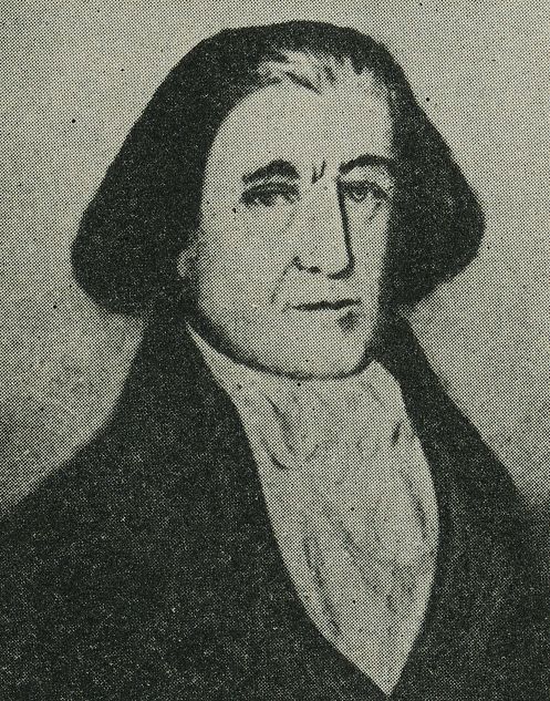
Image_Caption = Captain Robert Gray
AKA = Captain Gray discovers the Columbia River
Participants = Gray, crew of "Columbia Rediviva "
Location =Columbia River North America
Date =May 11 toMay 20 1792
Result = In May of 1792, American merchantsea captain Robert Gray sailed into the Columbia River, becoming the first recorded European to navigate into it. The voyage, conducted on the "Columbia Rediviva " was eventually used as a basis for theUnited States ' claim on thePacific Northwest , although its relevance to the claim was disputed by the British. As a result of the outcome the river was afterwards named after the ship. Gray spent nine days on the river trading fur pelts before sailing out of the river.Voyage
Captain Gray was a merchant ship captain born in
Rhode Island , whocircumnavigated the globe in between 1787 and 1790, in the course of a trading voyage out ofBoston, Massachusetts . He traveled first to the northPacific coast ofNorth America , to trade for furs, and then toChina , to trade the pelts for tea and other Chinese goods.cite web
title = Notable Oregonians: Robert Gray- Captain/Explorer
work = Oregon Blue Book
publisher = Oregon Secretary of State
url = http://bluebook.state.or.us/notable/notgray.htm
accessdate = 2006-12-11 ] After his return from that expedition, Gray set sail for the northwest coast again onSeptember 28 ,1790 , reaching his destination in 1792.cite web
last = Flora
first = Stephenie
title = Captain Robert Gray
publisher = OregonPioneers.com
url = http://www.oregonpioneers.com/gray.htm
accessdate = 2006-12-11 ]During his first voyage to the northwest coast, Gray was accompanied by Captain John Kendrick, who had remained in the Pacific, in command of the "
Lady Washington ". On the journey north along the coast toNootka Sound , Gray encountered a strong outflow near 46’16”. He spent nine days trying to enter the river without success before abandoning the effort and sailing north for Nootka. [Brown, J. Henry (1892). Political History of Oregon: Provisional Government. The Lewis & Dryden Printing Co.: Portland. P. 64] Gray rejoined Kendrick for a time after Gray's return to the region. In October the "Columbia" and crew began building Fort Defiance and a small craft the "Adventure" as they prepared to ride out the winter in harbor. [Howay, p. 248] After wintering onVancouver Island , Gray set sail again onApril 2 ,1792 when he left the American trading post of Clayoquot on Vancouver Island. On this journey aboard the "Columbia Rediviva " Gray noticed muddy waters flowing from shore and decided to investigate his belief that it might be the "Great River of the West". While waiting for favorable weather, Gray spotting a ship and exchanged greetings with her onApril 29 . This ship was the "HMS Discovery" commanded by British naval captainGeorge Vancouver , who doubted that Gray had found a navigable river-mouth.cquote|The several large rivers and capacious inlets that have been described as discharging their contents into the Pacific between the 40th and 48th degree north latitude, were reduced to brooks insufficient for our vessels to navigate, or to bays inapplicable for refitting.:"—Vancouver’s log,
April 28 ,1792 ." [Carey, Charles Henry. "History of Oregon". Vol. 1: Pioneer Historical Publising Co.:Chicago. 1922. p. 121]Gray informed Vancouver at this chance meeting that he had located a large river at the latitude of 46’10” but had been unable to enter it due to the outflow. [Carey. p. 122] However, Vancouver still doubted any river existed there:
So Gray informed Vancouver that he would further investigate that area, and then sailed south after several more days near the
Strait of Juan de Fuca . [Carey. p. 139]Entering the Columbia
The treacherous and shifting sand bar at the mouth of the
Columbia River estuary presented a challenge to any ship that attempted to enter the river. In April, Gray attempted to enter the mouth of the river, but bad weather forced him to give up.cite web
last = Oldham
first = Kit
title = Captain Robert Gray becomes the first non-Indian navigator to enter the Columbia River, which he later names, on May 11, 1792.
work = HistoryLink Essay
publisher = History Ink
date =January 13 ,2003
url = http://www.historylink.org/essays/output.cfm?file_id=5051
accessdate = 2006-12-11 ] After sailing north, meeting Vancouver, and spending a time inGrays Harbor , as it was later named, Gray returned to the river. This time he ordered a smallsailboat launched to attempt to find a safe passage across thesand bar s in the process known as sounding. Finally in the evening ofMay 11 ,1792 , Gray's men found a safe channel, and so ship and crew sailed into the estuary of the Columbia River.cite web
title = About Captain Robert Gray
work = Maritime History
publisher = Garibaldi Museum
url = http://www.garibaldimuseum.com/aboutGray.htm
accessdate = 2006-12-11 ] Once there they sailed upriver and Gray named this large river Columbia after his ship. The natives called the river Wimahl which translated to Big River. In addition to naming the river, Gray also named other landmarks such asAdams Point andCape Hancock . However, many of these places have since been re-named.Once entering the Columbia’s estuary, according to the ship’s log, they were met by many natives in their
canoe s, while the crew prepared to take on fresh water.cquote|When we were over the bar we found this to be a large river of fresh water up which we steered. Many canoes came alongside. At 1:00 P.M. came to with the small bower, in ten fathoms, black and white sand. …people employed in pumping the salt water out of our water-caskets in order to fill with fresh, while the ship floated in. So ends.:"—Gray's log" [Carey. p. 141]
Trading with the locals consisted mainly of exchanging nails and other small iron products for pelts,
salmon , and animal meat such as deer and moose. During the nine day trip on the river, the ship continued to trade amongst the natives on an almost daily basis while performing various repairs and maintenance on the ship.cite book
last = Brown
first = J. Henry
title = Political History of Oregon: Provisional Government
publisher = The Lewis & Dryden Printing Co.: Portland
date = 1892] Trading with these natives led to a collection of over 450 animal pelts to be traded in China.On
May 14 , the ship reached its furthest point inland, approximately 12-15 miles upriver. At this point the vessel ran aground briefly and the crew realized they had taken the wrong channel when sounding demonstrated the channel they were in had ended. The "Columbia" then started slowly to return downriver towards the mouth. Then the next day Captain Gray went ashore with his first mate Mr. Hoskins aboard a jolly-boat to view the country. Gray “landed on the north riverbank, raised the American flag, planted some coins under a large pine tree, and claimed possession for the United States.” [ [http://www.historylink.org/essays/output.cfm?file_id=5621HistoryLink.org Essay 5621] ] ByMay 18 , the ship was about six or seven miles from the bar. OnMay 19 the ship was anchored off the native village Chinoak, lead by the chief Polack. [Howay, Frederic W. "Voyages of the Columbia to the Northwest Coast". Boston: The Massachusetts Historical Society (1941), p. 398] On this day is when Gray officially named the river Columbia and bestowed other landmarks with names:Then on
May 20 , Gray and crew took up anchor around 1 pm to sail for the ocean. Around 2 pm they had sailed over the bar, and by 5 pm the "Columbia" had left the river and reached the open sea sailing north along the coast. The next day they passed by Grays Harbor on their journey north to rendezvous with their sloop "Adventure" before setting sail for China.cite web
title = Captain Robert Gray
publisher = Tacoma Public Schools
url = http://www.tacoma.k12.wa.us/schools/ms/gray/history.htm#captain
accessdate = 2007-07-31 ] However, before Gray and his crew sailed for China, they returned to Nootka Sound where he passed along news of his discovery to the Spanish commandant there, Quadra.cite book
last = Calhoun
first = John Caldwell
coauthors = James Buchanan
title = Oregon: The Claim of the United States to Oregon...
url = http://books.google.com/books?vid=OCLC54567507&id=XFRG2BcU01sC&printsec=titlepage&dq=British+Statement+of+1826+oregon
year = 1846
id = 5 ] Gray left with Quadra a chart and description of the river’s mouth that Captain Vancouver obtained a copy of in September. Upon leaving Nootka, the ship sailed for theChina market.cite book
last = Lockley
first = Fred
title = Oregon Trail Blazers
publisher = The Knickerbocker Press
date = 1929]Aftermath
A short time after entering the Columbia River and trading with the natives, ship and crew sailed to
China to sell the pelts before returning to Boston in July 1793. Gray's entering of the Columbia was later used, during theOregon boundary dispute , to support the American claim to theOregon Country , against the claim of Britain. The American and British diplomats raised many points in addition to Gray's voyage to support their cases. Neither side could agree that the other had established a clear and exclusive right of sovereignty. The British raised several points questioning whether Gray's voyage up the Columbia River had any value in establishing sovereignty. The Americans raised counter-points. No agreement was reached on this and many other points about the right to the Oregon Country. [Many of the points and counter-points raised and debated during the Oregon boundary dispute can be read in "Oregon: The Claim of the United States to Oregon", originally published in 1846 and available online at [http://books.google.com/books?id=XFRG2BcU01sC Google Books] ] In the end the dispute was resolved by compromise in theOregon Treaty of1846 . Upon Gray’s return, though, little was thought of his discovery. He did not publish it, cite web
last = Mussulman
first = Joseph
title = Great River of the West
work = Discovering Lewis & Clark
publisher = VIAs Inc.
url = http://www.lewis-clark.org/content/content-article.asp?ArticleID=577
accessdate = 2006-12-11 ] and the long-term consequences to which it contributed were unforeseen.Gray's Harbor , somewhat north along the coast from Columbia's mouth, is named for Robert Gray. Present dayAstoria, Oregon , whereJohn Jacob Astor would establish his trading post less than 20 years after Gray’s discovery, is situated on the south shore of the Columbia estuary.Due to Gray’s naming the river for his ship, the name Columbia has been attached to several names in the Pacific Northwest such as:
Columbia County, Oregon ;British Columbia ; Columbia Street inPortland, Oregon ;Columbia City, Oregon ;Columbia City, Seattle, Washington Crew of the "Columbia"
The following is a list of those on board the "Columbia" when it sailed from Boston:Captain Gray,
Robert Haswell (Chief Mate ),Joshua Caswell (second mate ), Owing Smith (third mate ), Abraham Waters (Fourth Mate),John Boit (Fifth Mate), John Hoskins, Samuel Homer, Jack atoe, Benjamin Harding/Harden, Samuel Yendell, Nahtan Dweley, John Emes, Popkins, Bart peas, Tom (the cook), Joseph Barnes, John Butler, Bryant Winle, Anteny Lows, Joseph Folger, Andrew Newhil, Elsworth, Weks, Obediar Weston, Isack, Ginnings, Sheperd, George Davidson (painter), Nickels (tailor), and Nathaniel Wooward. [Howay, Frederic W. "Voyages of the Columbia to the Northwest Coast". Boston: The Massachusetts Historical Society (1941), p. 447]Caswell, Barnes, and Folger were killed on
August 12 ,1791 by natives. [Howay, p. 375-376] Harding diedMarch 21 ,1792 ofdysentery . [Howay, p. 314] OnMarch 24 ,1792 , Haswell took command of the sloop "Adventure" with Waters and ten others and thus were not part of the discovery of the river. [Howay, p. 390]Previous explorations
In 1775, Spaniard
Bruno de Heceta (also spelled Hezeta) was exploring the northwest coast of North America with the vessels "Santiago" and "Sonora" under his command.Horner, John B. (1921). Oregon: Her History, Her Great Men, Her Literature. The J.K. Gill Co.: Portland. p. 30] On his return journey south, with only the "Santiago" and a reduced crew, Heceta discovered a large bay penetrating far inland. He tried to sail in but the strong currents prevented it, even under a full press of sails. His crew was so reduced that they could not handle the anchor so he could not easily wait for better conditions. He wrote that the seething currents led him to believe it was the mouth of a great river or a passage to another sea. He named the bay "Bahia de la Asunciõn" and produced a map of what he could discern from outside the Columbia bar. Later Spanish maps often showed the Columbia River's estuary with the name "Entrada de Hezeta", "Rio de San Roque", and similar variants. [Hayes, Derek. "Historical Atlas of the Pacific Northwest: Maps of exploration and Discovery". Sasquatch Books. 1999. ISBN 1-57061-215-3. pp. 38-39.]Captain
John Meares , during his 1788 exploration of the Pacific Northwest, had on board a copy of a Spanish map made byAntonio Francisco Maurelle andJuan Francisco de la Bodega y Quadra which showed the Columbia River's mouth as "Entrada descubierta por Dn Bruno Hezeta". On July 6, aboard the 230-ton snow "Felice Adventurer", Meares sailed off the mouth of the river at the latitude indicated on the Spanish map, but was unable to find the mouth. [Hayes, p. 60.] He did see the cape on the north side of the entrance and named itCape Disappointment , reflecting his failure to find the river's mouth. This lead Meares to write is his log: "We can now with safety assert, that no such river as that of St. Roc exists, as laid down in the Spanish charts." [http://www.historylink.org/essays/output.cfm?file_id=5621HistoryLink.org Essay 5621] ]The last known attempt on the Columbia River before Gray’s successful entering of the river was Captain Vancouver’s visit in April 1792.
ee also
*
Nootka Crisis
*Vancouver Expedition References
External links
* [http://www.washington.edu/uwired/outreach/cspn/Website/Hist%20n%20Lit/Part%20Two/Texts/Gray%20Columbia.html Captain Robert Gray, "Official Log of the Columbia" (1792)]
Wikimedia Foundation. 2010.