- Interstate 474
Infobox road
state=IL
route=474
type=I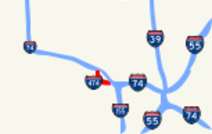
maint=IDOT
length_mi=14.88
length_round=2
length_ref=cite web |author=Illinois Technology Transfer Center |url=http://www.dot.state.il.us/gist2/select.html |title=T2 GIS Data |accessdate=2007-11-08 |date=2006]
year_established=Late1970s Kurumi. [http://www.kurumi.com/roads/3di/ix74.html 3-digit Interstates from I-74] . Last updated November 24, 2005. Retrieved March 27, 2006.]
direction_a=West
terminus_a=Jct|state=IL|I|74|IL|6 in Peoria, IL
junction=
direction_b=East
terminus_b=Jct|state=IL|I|74 west of Morton, IL
previous_type=IL
previous_route=394
next_type=IL
next_route=1Interstate 474 (abbreviated I-474) is an
interstate highway loop route that provides a southern bypass around the north centralIllinois city of Peoria. I-474's parent interstate is I-74. As the first digit of the interstate's number is even, it follows the established convention of providing a loop around a city. Interstate 474 is convert|14.88|mi|km|2 long. I-474 is the highest numbered route in the state of Illinois.Route description
Interstate 474 is a modern, Interstate-standard four-lane freeway for its entire length. Prior to 2006, thru truck traffic on I-74 was instructed to use I-474. This is because prior to its 2004-2007 reconstruction, Interstate 74 was significantly below Interstate standard, having numerous 15 mph onramps and offramps, extremely short merging space for onramps (some less than 500 feet (152 m) in length), and a 45 mph speed limit through downtown Peoria.
The
Illinois Route 116 access interchange at Maxewell Road has been indicated as the eastern terminus for the Quincy to Peoria expressway now known as theIllinois Route 336 project.Illinois Department of Transportation. [http://www.peoriatomacomb.com/maps/3slice/sect3grid_r1_c5.gifImage of eastern end of project maps] from [http://www.peoriatomacomb.com/ Peoria to Macomb IDOT site] . Retrieved March 27, 2006.]The western terminus of the interstate is at I-74, exit #87A. The eastern terminus of the route is at I-74, exit #100. North of the western terminus, the route continues as
Illinois Route 6 with a new series of exit numbers.History
I-474 was constructed through the mid 1970s. The now-named
Shade-Lohmann Bridge was erected in 1973. During that year, $30.1 million was allocated for acquisition of right-of-way, grading work and overpass/bridge construction across the whole length of the highway.cite |author=R.L. Polk and Company |title=Polk's Peoria City Directory |date=1973 |publisher=R.L. Polk and Co. Publishers]Exit list
References
External links
* [http://illi-indi.com/il_EndsPage.php?id=3474§ion=1 Illinois Highway Ends: Interstate 474]

Wikimedia Foundation. 2010.