De Cordova Bend Dam

De Cordova Bend Dam
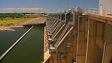
View of the dam from the east
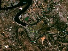
De Cordova Bend Dam as seen by satellite from NASA World Wind

The De Cordova Bend Dam is a man-made dam on the Brazos River in Hood County, Texas, United States, controlled by the Brazos River Authority. De Cordova Bend Dam forms the 8,300-acre (34 km2) Lake Granbury. The dam is so named because of the clockwise almost-complete loop in the Brazos River named De Cordova Bend after Jacob De Cordova.

The dam is one of only three damming the Brazos River.

Contents

Location and Access

Location of De Cordova Bend Dam

The dam is located at 32°22′26″N 97°41′15″W / 32.37393°N 97.68753°W / 32.37393; -97.68753Coordinates: 32°22′26″N 97°41′15″W / 32.37393°N 97.68753°W / 32.37393; -97.68753 (32.37393, -97.68753).[1]

The dam is southeast of Granbury, Texas and road access is available by Rainey Ct which crosses the dam.

History

The lake was first proposed in the late 1950s. Construction was begun on the Cordova Bend Dam on December 15, 1966 by the H. B. Zachry Company.[2] Impoundment of water began on September 15, 1969.

The proposed construction of the De Cordova Bend Dam in the mid-1950s became the impetus for John Graves' book, Goodbye to a River.

References


Wikimedia Foundation. 2010.

Игры ⚽ Нужно решить контрольную?

Look at other dictionaries:

  • Lake Granbury — infobox lake lake name = Lake Granbury image lake = caption lake = type = Reservoir location = Hood County, Texas coords = coord|32|28.616667|N|97|47.40000|W|region:US TX type:waterbody|display=inline,title inflow = Brazos River outflow = Brazos… …   Wikipedia

  • List of dams and reservoirs in the United States — This list is incomplete; you can help by expanding it. The following is a partial list of dams and reservoirs in the United States. There are an estimated 75,000 dams in the United States, impounding 600,000 mi (970,000 km) of river or about 17%… …   Wikipedia

  • List of reservoirs and dams in the United States — There are an estimated 75,000 dams in the United States, blocking 600,000 miles (960,000 km) of river or about 17% of rivers in the nation . [cite web|url=http://www.pcffa.org/dams.htm |title=Dams and salmon |accessdate=2008 02 11] The following… …   Wikipedia

  • List of casinos — A list of casinos.Antigua and Barbuda*St. James s Club Antigua in Mamora Bay *Casino Riviera in Runaway Bay *Grand Princess Casino in St. John s *King s Casino in St. John sAustraliaNew South Wales*Star City Casino (Sydney)Victoria*Crown Casino… …   Wikipedia

  • Liste von Flüssen in den Vereinigten Staaten — Die folgende Liste zeigt eine Vielzahl von Flüssen in den Vereinigten Staaten und deren Territorien auf Inhaltsverzeichnis A B C D E F G H I J K L M N O P Q R S T …   Deutsch Wikipedia

  • Moline, Illinois — City of Moline Moline, Illinois skyline. Location in Illino …   Wikipedia

  • Mississippi River — For the river in Canada, see Mississippi River (Ontario). Coordinates: 29°09′04″N 89°15′12″W / 29.15111°N 89.25333°W / …   Wikipedia

  • Quad Cities — This article is about the five cities known collectively as the Quad Cities . For other uses, see Quad Cities (disambiguation). Davenport Moline Rock Island, IA IL Common name: Quad Cities …   Wikipedia

  • National Register of Historic Places listings in Alabama — This is a list of buildings, sites, districts, and objects listed on the National Register of Historic Places in Alabama. Contents: Counties in Alabama   (links in italic lead to a new page) Autauga Baldwin Barbour Bibb Blount Bullock Butler …   Wikipedia

  • DeCordova, Texas —   City   Nickname(s): Millennium City Locat …   Wikipedia

Share the article and excerpts

Direct link
Do a right-click on the link above
and select “Copy Link”