- Smolen-Gulf Bridge
Infobox Bridge
bridge_name = Smolen-Gulf Bridge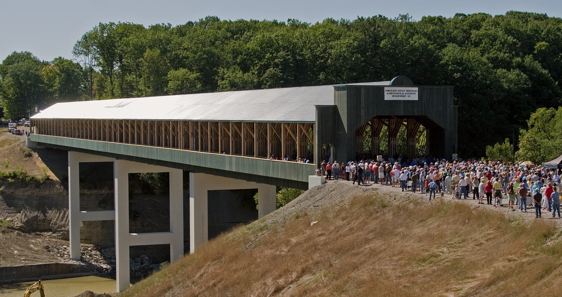
caption =
official_name = Smolen-Gulf Bridge [http://ashtabulacountyengineer.org/ Ashtabula County Engineer's office] ]
carries =
crosses = Ashtabula River
locale =Ashtabula County, Ohio
maint = Ashtabula County Engineer
id =
designer = John Smolen
design = modified Pratt Truss
material = glue laminated Southern Yellow Pine
spans =
pierswater =
mainspan = 4 x convert|150|ft
length = convert|613|ft
width = convert|51|ft (overall)
convert|30|ft (roadway)
height = convert|37|ft
load = HS 25-44 Ohio Legal
clearance = convert|14.5|ft
below = convert|93|ft
traffic = 2065 (previous bridge)
begin = 2006-08-08
complete = 2008-10-01 (projected)
open = 2008-10-01 (projected)
closed =
toll =
map_cue =
map_
map_text =
map_width = 250px
coordinates = coord|41|51|19.584|N|80|45|43.74|W|city
lat =
long = The Smolen-Gulf Bridge is acovered bridge which will carry a realigned State Road (Ashtabula County Road 25) across theAshtabula River and the Plymouth and Ashtabula Township line in northern Ashtabula County,Ohio ,United States . At 613 feet (182.9meter s), it is the longest covered bridge in the United States – a title formerly held by theCornish-Windsor Covered Bridge inNew Hampshire – and the fourth longest covered bridge in the world." [http://www.starbeacon.com/siteSearch/apstorysection/local_story_290075133 New span to be ready for 2008 festival] ", "Star Beacon ", published October 17, 2006] The bridge was designed by John Smolen, former Ashtabula County Engineer when the idea of bridging the Ashtabula River Gulf with a wooden structure was first conceived in 1995." [http://www.starbeacon.com/local/local_story_233194650.html Nation's longest covered bridge to be dedicated] ", "Star Beacon ", posted August 20, 2008] cite news |first=Carl E. |last=Feather |authorlink= |coauthors= |title=Nation’s longest covered bridge dedicated, named in ceremony |url=http://www.starbeacon.com/local/local_story_239195733.html |work=Star Beacon |publisher= |date=2008-08-26 |accessdate=2008-08-28 ]Construction
The county's 17th publicly accessible covered bridge cost approximately $7.78 million to build," [http://www.starbeacon.com/siteSearch/apstorysection/local_story_245075133 Commissioners OK higher bridge costs] ", "
Star Beacon ", published September 02, 2006] and features walkways along both sides. It is constructed of four convert|152|ft sections" [http://www.starbeacon.com/archivesearch/local_story_197190345.html Getting Ready for Dedication"] , "Star Beacon ", posted July 15, 2008] that rest on concrete abutments and three concrete piers, and rises more than convert|93|ft over the river, carrying two lanes of legal-weight traffic." [http://www.starbeacon.com/Currents/local_story_283150034.html?keyword=secondarystory Under way, but a long ways to go] ", "Star Beacon ", published October 10, 2007] The bridge consists of convert|3|ft -thick pieces of Douglas fir or yellow pine, with hemlock or yellow poplar being used for the siding. The builder was Union Industrial Contractors and Koski Construction.The previous bridge which carried State Road across the Ashtabula River was located at coord|41|51|19.584|N|80|45|43.74|W|city (41.85544, 80.76215), [http://mapper.acme.com/?ll=41.85544,-80.76215&z=14&t=H ACME Mapper 2.0] ] approximately 1.6 mi (2.5
km ) east-southeast of Ashtabula, and the new bridge is at the same coordinates because it was built directly above the old bridge site.The bridge was dedicated the afternoon
August 26 ,2008 , where the name was unveiled. [cite news |first= |last= |authorlink= |coauthors= |title=Ashtabula: Record-setting covered bridge dedicated Tuesday |url=http://www.wkyc.com/news/local/news_article.aspx?storyid=95272 |work= |publisher=WKYC-TV |date=2008-08-26 |accessdate=2008-08-26 ] The county already has aState Road Covered Bridge located along a different "State Road" (C-354) overConneaut Creek in Monroe Township, which is the reason for the name chosen for this bridge.State Road (C-25) is being realigned through the gulf" [http://www.starbeacon.com/siteSearch/apstorysection/local_story_200075133 Commissioners award covered bridge contract] ", "
Star Beacon ", published July 18, 2006] , and its approaches to the bridge are expected to be opened the weekend of October 11-12, 2008.cite news |first=Shelley |last=Terry |authorlink= |coauthors= |title=Bridge wait a little bit longer |url=http://www.starbeacon.com/local/local_story_276224751.html |work=Star Beacon |publisher= |date=2008-10-02 |accessdate=2008-10-10 ]Directions to bridge
*From State Route 11, exit at State Route 84 and head southwest approximately 0.4 miles.
*Turn left (south) on State Road (C-25) and continue 0.6 miles to the bridge. [ [http://local.live.com/default.aspx?v=2&cp=41.858879~-80.766071&style=r&lvl=15&tilt=-90&dir=0&alt=-1000&rtp=pos.qz9fy2882r9d_Origin~pos.qz89p1882v7s_Destination Windows Live Local] ]ee also
*
List of Ashtabula County covered bridges References
External links
*Geolinks-US-streetscale|41.85544|-80.76215
* [http://www.roadfan.com/temp3/smobrbr.html Scans of opening day brochure]
* [http://www.dalejtravis.com/cblist/cboh.htm Ohio Covered Bridges List]
* [http://members.aol.com/jreinhl/index.htm Ohio Covered Bridge Homepage]
* [http://members.aol.com/jreinhl/maps/numbers.htm The Covered Bridge Numbering System]
* [http://oldohiobridges.com/ohba.htm Ohio Historic Bridge Association]
* [http://www2.dot.state.oh.us/se/coveredbridges/ Ohio Covered Bridges]
* [http://www.mainavenuemusic.com/2007-06-13/index.htm Images of construction progress.]
*cite news |first=Carl E. |last=Feather |authorlink= |coauthors= |title=Moving closer to reality |url=http://www.starbeacon.com/archivesearch/local_story_176072314 |work=Star Beacon |publisher= |date=2007-06-25 |accessdate=2008-08-28
*cite news |first=Carl E. |last=Feather |authorlink= |coauthors= |title=The bridge in his viewfinder |url=http://www.starbeacon.com/archivesearch/local_story_268183451.html |work=Star Beacon |publisher= |date=2008-09-24 |accessdate=2008-09-30 Includes documentary information.
Wikimedia Foundation. 2010.