South Denmark Road Covered Bridge

South Denmark Road Covered Bridge

Infobox U.S. Covered Bridge
bridge=South Denmark Road Bridge


image_size=260px
bridge_


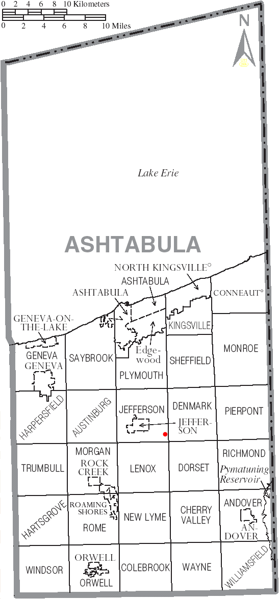
bridge_map_size=250px
state=Ohio
county=Ashtabula County
length=100
truss=single span, Town truss
built=1895
renovated=
builder=

South Denmark Road Bridge is a covered bridge spanning Mill Creek in Denmark Township, Ashtabula County, Ohio, United States. The bridge, one of currently 15 drivable bridges in the county, is a single span Town truss design. Bypassed in 1975, the bridge still remains open to light traffichttp://www.coveredbridgefestival.org/bridges.htm Ashtabula County Ohio Covered Bridge Festival] . The bridge’s WGCB number is 35-04-14 [http://www.dalejtravis.com/bridge/ohio/htm/3500414.htm Ohio Covered Bridges List, 35-04-14] , and it is located at coor dms|41|43|1.956|N|80|41|25.332|W|city (41.71721, 80.69037)http://mapper.acme.com/?ll=41.71721,-80.69037&z=14&t=H ACME Mapper 2.0] approximately 4.4 mi (7.0 km) east-southeast of Jefferson.

Directions to bridge

*From State Route 11, exit at State Route 307 and head northwest approximately 0.1 miles.
*Turn right (north) on Overly Road (T-188) and continue 1.4 miles.
*Turn right (east) on South Denmark Road (C-291) and continue 1.3 miles.
*Turn right (southeast) on Old South Denmark Road to the bridge [http://local.live.com/default.aspx?v=2&cp=41.712927~-80.702194&style=r&lvl=14&tilt=-90&dir=0&alt=-1000&rtp=pos.qyhc6d886nhc_Origin~pos.qykmbw88870m_Destination Windows Live Local] .

History

*1895 – Bridge constructed.
*1975 – Bridge bypassed.

Dimensions

*Span: 76 feet (23.2 m)
*Length: 100 feet (30.5 m)
*Width: 13 feet 3 inches (4.0 m)
*Height: 11 feet (3.4 m)

Gallery

ee also

*List of Ashtabula County covered bridges

References

External links

*Geolinks-US-streetscale|41.71721|-80.69037
* [http://www.dalejtravis.com/cblist/cboh.htm Ohio Covered Bridges List]
* [http://members.aol.com/jreinhl/index.htm Ohio Covered Bridge Homepage]
* [http://members.aol.com/jreinhl/maps/numbers.htm The Covered Bridge Numbering System]
* [http://oldohiobridges.com/ohba.htm Ohio Historic Bridge Association]
* [http://www.dot.state.oh.us/se/coveredbridges/ashtabula/ah0414f.htm South Denmark Road Covered Bridge] from [http://www.dot.state.oh.us/se/coveredbridges/#ODOT Ohio Covered Bridges, Historic Bridges]


Wikimedia Foundation. 2010.

Игры ⚽ Поможем сделать НИР

Look at other dictionaries:

  • Netcher Road Covered Bridge — Netcher Road Bridge Locale Ashtabula County, Ohio, United States Design single span, timber arch with inverted Haupt walls …   Wikipedia

  • Denmark — /den mahrk/, n. a kingdom in N Europe, on the Jutland peninsula and adjacent islands. 5,268,775; 16,576 sq. mi. (42,930 sq. km). Cap.: Copenhagen. * * * Denmark Introduction Denmark Background: Once the seat of Viking raiders and later a major… …   Universalium

  • Denmark — This article is about the country. For other uses, see Denmark (disambiguation). Denmark Danmark …   Wikipedia

  • List of road-rail bridges — Road rail bridges are bridges shared by road and rail lines, as an economy measure compared to providing separate bridges. Road and rail may be provided with separate tracks, so that trains may operate at the same time as cars (eg the Sydney… …   Wikipedia

  • South London Route Utilisation Strategy — Network Rail s (NR) South London Route Utilisation Strategy (SLRUS), published in March 2008[1][2][3] (SLRUS) was the eighth Route Utilisation Strategy to be produced. By default, RUSs are established by the Office of Rail Regulation (ORR) unless …   Wikipedia

  • South Africa — Republic of, a country in S Africa; member of the Commonwealth of Nations until 1961. 42,327,458; 472,000 sq. mi. (1,222,480 sq. km). Capitals: Pretoria and Cape Town. Formerly, Union of South Africa. * * * South Africa Introduction South Africa… …   Universalium

  • A215 road — Major junctions …   Wikipedia

  • Golden Gate Bridge — Carries 6 lanes of …   Wikipedia

  • London, Brighton and South Coast Railway — The London, Brighton and South Coast Railway (LB SCR) (commonly known as the Brighton line ) was a railway company in the United Kingdom from 1846 to 1923. Its territory formed a rough triangle, with London at its apex and practically the whole… …   Wikipedia

  • National Register of Historic Places listings in Ashtabula County, Ohio — Location of Ashtabula County in Ohio This is a list of the National Register of Historic Places listings in Ashtabula County, Ohio. This is intended to be a complete list of the properties and districts on the National Register of Historic Places …   Wikipedia

Share the article and excerpts

Direct link
Do a right-click on the link above
and select “Copy Link”